- Olton
-
Coordinates: 52°26′16″N 1°48′21″W / 52.4377°N 1.8058°W
Olton 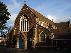
St Margaret's Church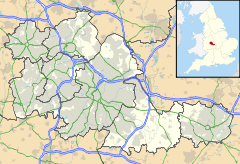
 Olton
Olton
Olton shown within the West MidlandsPopulation 6,770 (2001 Census) - London 117 mi (188 km) Metropolitan borough Solihull Metropolitan county West Midlands Region West Midlands Country England Sovereign state United Kingdom Post town SOLIHULL Postcode district B92 Dialling code 0121 Police West Midlands Fire West Midlands Ambulance West Midlands EU Parliament West Midlands UK Parliament Solihull List of places: UK • England • West Midlands Olton is an area of the Metropolitan Borough of Solihull in the West Midlands, England. In the 13th century the Lords of the Manor moved their seat and formed a new settlement, in the junction of two major roads, that village has now grown into a big town called Solihull. It was then that Ulverlei was being referred to as 'Oulton' (meaning 'old town') to distinguish it from the 'new town' of Solihull of which it is now a part. It is located on the A41 between Solihull town centre 4 miles (6.4 km), Acocks Green, 2 miles (3.2 km) and Birmingham 5.7 miles (9.2 km), dating back over a 1,000 years, it is a now a residential suburb, though historically part of Warwickshire. Many of the large houses built in St. Bernard's Road and Kineton Green Road during the Victorian and Edwardian period form part of one of Solihull's conservation areas.
Contents
History
Olton means 'old town' and is the site of the manor of Ulverlei from where Solihull was founded. Ulverlei has been translated to mean Wulfhere's clearing or meadow.[1] Wulfhere was the first Christian king of all of Mercia, from the end of the 650s until 675. Wulfhere's father, Penda, was killed in 655 fighting against Oswiu of Northumbria. Penda's son Peada became king under Oswiu's overlordship, but was murdered a year later. Wulfhere came to the throne when Mercian nobles organized a revolt against Northumbrian rule in 658, and drove out Oswiu's governors.[2] As he was a youth, Wulfhere had been kept in hiding until he came of age.[3]
After the absorption of Mercia into the rest of England, Ulverlei became the property of the Earls of Mercia, who if not descendants of the royal house were their successors. The first of these was Leofric, husband of Godiva, heroine of the Coventry legend, and the earldom descended through his son Ælfgar to Edwin, his grandson, who was in possession at the time of the Norman conquest. Perhaps, because of the royal connection, William I granted the lands to Christina, who was descended from King Edmund Ironside.[1]
The Domesday Book records Ulverlei as part of the lands of Christina, sister of Edgar the Ætheling, the last male of the house of Cerdic of Wessex, the original ruling dynasty of England. It states, "In Coleshill Hundred Christina holds 8 hides in Ulverlei from the King. Land for 20 ploughs. In lordship 1; 3 slaves. 22 villagers with a priest and 4 smallholders have 7 ploughs. Meadow, 12 acres; woodland 4 leagues long and 1/2 league wide; when exploited, value 12s. The value was £10; now £4. Earl Edwin held it."[4]
Shortly after the Domesday Book was compiled in 1086, Christina "took the veil"[2] entering the nunnery of Romsey Abbey in Hampshire. Her lands were granted to Ralph de Limesi whose family held Ulverlei until his great grand daughter married Hugh de Odingsells, whose family were thought to be of Flemish origin. William De Odingsells succeeded his father in 1238 and it was in his time that the new village of Solihull began to develop.[1]
That Ulverley stood where Olton now does is evident from the survival of the place names of Ulverley Green and the Ulleries. Ulverley Green close to the Birmingham-Warwick Road is the probable site of the original Saxon manor house.[1] The site was described by Hutton
"Four miles from Birmingham on upon the Warwick Road, entering the parish of Solihull in Castle Lane, is Ulverley, in doomsday Ulverlei. Trifling as this place now seems it must have been the manor house of Solihull, under the Saxon heptarchy, but went to decay so long ago as the conquest. The manor was the property of the Earls of Mercia, but whether their residence is uncertain. The traces of a moat remain, which are triangular, and enclose a wretched farmhouse of no note; (named Manor House Farm)[5] one of the angles of the moat is filled up and becomes part of Castle Lane, which proves that Ulverley went into disuse when Hogg's moat was erected; it also proves that the lane terminated here, which is about 200 yards from the turnpike road. The great width of the lane, from the road to Ulverley, and its singular narrowness from thence to Hogg's moat, is another proof of its antiquity. If we pursue our journey half a mile further along this lane which, by the way, is scarcely passable, it will bring us to Hogg's moat."[6]
This site is now the Scheduled Ancient Monument of Hobs Moat,[7] standing back from Lode Lane. The Hugford family occupied it after the Odingsells, Burman suggested that the name could as easily come from the Hugfords as the Odingsell's,[1] as Hutton calls it Hoggs Moat in his 1782 description.[6] However, Dugdale believed it derived from "Odingsells moat" and states he has seen Odingsells incorrectly written as "Hodingsells" and believes the corruption came from that.[8] The Reverend Pemberton wrote that, "the moat, surmounted as it would have been by a stockade, would have been a formidable obstacle to assault"[9] The Odingsells name is still to be found in the modern road name of Odensil Green built on the site of Odensil Farm.
Probably due to the relocation of the Lords of the Manor to the new settlement of Solihull, Olton declined in comparison[1] and remained largely agricultural until opening of the station in 1869 and the development of St Bernard's Road. Part of the road that later be came St Bernard's Road appears on the 1839 Tithe map and, in 1869, a new road was constructed to link this road with the Warwick Road. Originally named Windmill Road, it had become St Bernard's Road by 1872, named after the seminary that was being built. The first house to be constructed in the road is thought to be Elmhurst (no. 21), which was used for a gathering of 200 people in 1872.[10]
Landmarks
The Scheduled Monument of Hob's Moat, the derivation of its name is discussed above, is situated in Lode Lane, on the north-facing slope of a low hill and includes a moated site and the earthwork remains of a section of a hollow way. The moated site has external dimensions of approximately 137 metres north to south and 115 metres east to west. The steep sided moat ditches are dry and measure up to 7 metres wide and 2.5 metres deep. External banks are visible on all four sides of the moated site and although the northern and eastern banks have been lowered they can be traced on the ground surface. The banks are approximately 12 metres wide at their base and have an average height of 1.8 metres. The moated island is 0.65 hectares in area and slopes gradually from south to north. There is an internal enclosure bank on the west, north and east sides of the island, running parallel to the moat ditches. An excavation across a section of the inner bank in 1985 provided evidence for the bank's construction; deposits of stony clay mounded up over a sandy gravel core. A second bank was located beneath the inner one which consists of a sandy bank revetted on either side by bands of cobbles set in clay. This feature is earlier in date than the inner bank and employs a different construction technique. An excavation in the southern half of the moated island has indicated that the structures which originally occupied the island will survive as buried features. The remains of a small structure, bounded by walls set within shallow foundation slots, were located. Excavations within the moat have recovered evidence for a collapsed sandstone wall, and suggested a late 13th century date for its construction. The remains of the wall had been overlain by the base of a later structure. Immediately alongside the north side of Hob's Moat are the earthwork remains of a hollow way which is medieval in origin.[11] Excavation, geophysical and field survey carried out between 1985-86 reveled pottery found in a trench excavated across the inner rampart and interior indicating a 13th century construction date, with later modifications to the enclosing earthworks. The remains of a number of medieval buildings were found, and in addition a late medieval/early post medieval shed-like structure. The activity on the site during the 17th century and later appears to be agricultural.[12][13] A survey carried out in October 1997 by RCHME concluded that he site was probably a homestead or hunting lodge.[14]
Governance
Politically, the Olton ward has recently leaned towards liberalism. Since 1973, the three seats on Solihull Council have been shared by Conservative and Liberal (later, Liberal Democrat) councillors. Honor Cox of the Liberal Democrats held the ward from 1991 until her death on 1 November 2010.[15] However, for several years now all three seats have been held by the Liberal Democrats. Olton has a strong residents' association that liaises with Solihull Council and other bodies to improve the locality.
Nationally, Olton is a ward of the Solihull constituency whose Member of Parliament is Lorely Burt, the first Liberal Democrat MP for Solihull.[1] Olton is included in the West Midlands electoral region of the European Parliament and the six members are; Mike Nattrass (UK Independence), Liz Lynne (Liberal Democrat), Malcolm Harbour (Conservative), Michael Cashman (Labour), Philip Bradbourn OBE (Conservative) and Nicole Sinclaire (UK Independence).
Transport
The Grand Union Canal and the Leamington Spa to Birmingham railway line pass through the village. Olton railway station situated in approximately the geographical centre of the area is served by London Midland to Birmingham, Dorridge and Leamington Spa and Chiltern Railways to Warwick, High Wycombe and London Marylebone.
The West Midlands Warwick Road bus No 37 operated by Travel West Midlands runs along the A41 linking Olton with Solihull in the south and Birmingham to the north.
Motorway access is via junction 5 of the M42 at Knowle 4.3 miles (6.9 km) away with links to the M5, M6 and M40 motorways.
The nearest airport is Birmingham International Airport situated 5.5 miles (8.9 km) to the North.
Education
There are seven primary schools, one special school and two secondary schools in the area.
Religious sites
 United Reform Church
Situated at the junction of the Warwick Road with St Bernards Road and Kineton Green Road is the parish church of St. Margaret's, begun in 1880 as a chancel and completed by B. Corser in 1896.[16] It has rock faced walls, no tower and round piers with well carved naturalistic flower capitals.[17]
To the south is the Roman Catholic Olton Friary. Built in 1873 as St Bernard's Catholic Seminary by Bishop William Bernard Ullathorne, the first Catholic bishop of Birmingham, it closed in 1889 when the bishop's successor moved the seminary to Oscott. The building was purchased by the Capuchin Friars and became the Franciscan Monastery of the Immaculate Conception. The friars left on 10 January 1981 and the Sacred Heart Fathers and Brothers of Bétharram took over the running of the parish.[10]
There is also the United Reform church on Kineton Green Road and Olton Baptist Church meets at Langley School on Kineton Green Road.
On the Warwick road just by the rail bridge is the former Congregational Chapel which appears on early 20th century maps, the building is now a bridal shop.
Located on Monastery Road the Solihull and District Hebrew Congregation hold regular religious services at their Solihull Synagogue as well as running a wide range of social activities.[18]
Sports and leisure
Two golf clubs lie in the wealthy southern part of Olton, namely Robin Hood Golf Club and Olton Golf Club, as does a hockey club Olton and West Warwickshire Hockey Club, whilst in Grange Road there is the Olton and West Warwickshire Cricket Club.
Olton Mere was created as a reservoir to act as a feeder for the Grand Union Canal, which was opened in 1799. The Mere was formed from marshland fed by Folly Brook (now Hatchford Brook) and was designed to hold 150 locks full of water, but this was not achieved until the Mere was extended in 1834. It is the largest of the few areas of open water in Solihull and supports a large number of waterfowl. The woodland surrounding the Mere has remained undisturbed for many years, providing an important habitat for plants and animals. There is no public access to the Mere, which has been designated a Site of Special Scientific Interest for nature conservation. However, there is a good view of the Mere from the trains travelling between Solihull and Olton. The Olton Mere Sailing Club[19] also has a membership category for those who wish to have walking access to the Mere.[10]
Notable people
Frederick William Lanchester, Hon FRAeS (October 23, 1868 - March 8, 1946) was an English polymath and engineer who made important contributions to automotive engineering, aerodynamics and co-invented the field of operations research. He was also a pioneer British motor car builder, a hobby he eventually turned into a successful car company, and with Harry Ricardo and Henry Royce is considered one of the "big three" English car engineers. Between 1893-97 he lived at 'Fairview' (No. 25) St Bernard's Road[10] and it was here that Lanchester designed a new petrol engine which he installed in a flat-bottomed launch, built in the garden of his home, driven by the engine via a stern paddle wheel.
Edith Blackwell Holden (1871–1920) the author of "The Country Diary of an Edwardian Lady" was a British artist and art teacher, known in her time as an illustrator of children's books. Much influenced by the Arts and Crafts movement, she specialized in painting animals and plants. Holden was made famous by the posthumous publication, in 1977, of her Nature Notes for 1906 under the title The Country Diary of an Edwardian Lady. She was living in Kineton Green Road, Olton, Solihull in 1905-6 when she recorded the notes. The collection of seasonal observations, poetry, and pictures of birds, plants, and insects—which was never even considered for publication when it was composed—had the nostalgic charm of a vanished world seven decades later. It was a best seller.[20]
Alfred John Bostock Hill, also known as Alfred John Bostock-Hill an English cricketer was born in Olton on 8 April 1887.[21] A right-arm bowler, he played one first-class match for Warwickshire in 1920.[22] The nephew of Warwickshire players Henry Hill[23] and John Hill,[24] he later had a more successful cricket career in the Far East.[25] He died in Devon aged 72 on 20 August 1959.
Bernard William Quaife an English cricketer who played more than 300 first-class matches between the wars was born in Olton on 24 November 1899. He was the son of England Test player Willie Quaife. He played first for Warwickshire, but later found much more success at Worcestershire, where (unlike at his original county) he became the usual wicket-keeper. He died in Bridport, Dorset on 27 November 1984.
Felicity Kendal, CBE, actress, was born in Olton 1946, but spent much of her childhood in India, where her father managed a touring rep company. In 1965 she returned to Britain but struggled in her career until 1975, when she started playing Barbara Good in the BBC sitcom The Good Life. This made her a household name, although later sitcoms, where she was the lead, did not achieve the same popularity. In 2003, she first played Rosemary Boxer in Rosemary & Thyme, a murder mystery drama broadcast for three series ending in 2007.
Johnnie Walker, Disc Jockey, Johnnie Walker MBE was born Peter Waters Dingley, 30 March 1945 in Olton. His father sold electroplating equipment for car parts and he was educated at Solihull School, where he enjoyed music lessons and rugby, but failed his O-Level examinations. He obtained employment in the motor trade, studied for a City and Guilds qualification in motor mechanics at Gloucester Technical College and aspired to be car salesman, before becoming a DJ in bars and ballrooms.[26] His broadcasting began in 1966 on offshore pirate radio station Swinging Radio England, before moving to Radio Caroline moving to the BBC in April 1969, after Radio Caroline was closed.
References
- ^ a b c d e f In the Forest of Arden, John Burman, 1948
- ^ a b The Anglo-Saxon Chronicle, translated and edited by M. J. Swanton (1996), paperback, ISBN 0-415-92129-5
- ^ Ecclesiastical History of the English People, Bede, 731
- ^ Domesday Book for Warwickshire, Phillimore edited by John Morris ISBN 0 85033 141 2
- ^ 19thc O.S Map
- ^ a b History of Birmingham, William Hutton, 1782
- ^ Hobs Moat at casteluk.net
- ^ The Antiquities of Warwickshire, William Dugdale, 1656
- ^ Solihull and its church, Rev. Robert Pemberton, 1905
- ^ a b c d Solihull Council Web site
- ^ English Heritage National Monuments Record for Hob's Moat Accessed 22 February 2010
- ^ Moated Sites Research Group report 13 Page(s)21-3
- ^ Medieval Settlement Research Group : annual report 2 Page(s)25-6
- ^ Field Investigators Comments G Brown/31-OCT-1997/RCHME Hobs Moat Survey
- ^ Article at Solihull.News.net
- ^ A History of the County of Warwick: Volume 4: Hemlingford Hundred (1947), pp. 214-229. [URL: http://www.british-history.ac.uk/report.aspx?compid=42685 Date accessed: 31 January 2010.]
- ^ Nikolaus Pevsner and Alexandra Wedgwood, The Buildings of England, Warwickshire, 1966, ISBN 014 0710.31 0
- ^ Solihull and District Hebrew Congregation
- ^ Olton Mere Sailing Club
- ^ *Dictionary of Unitarian and Universalist Biography entry
- ^ Cricinfo profile
- ^ CricketArchive profile
- ^ Henry Hill at CricketArchive
- ^ John Hill at CricketArchive
- ^ Other matches played by Alfred Hill at CricketArchive
- ^ Walker, Johnie (2007). /Johnnie Walker. Michael Joseph. ISBN 978-0-718-14853-9.
External links
- Ordnance Survey map of Olton (on far right)
- Olton & West Warwickshire Hockey Club
- Olton and West Warwickshire Cricket Club
- West Warwickshire Sports Club
- Solihull Model Railway Circle
- Olton Mere Sailing Club
- The Solihull Council Website
Ceremonial county of West Midlands Metropolitan districts Major settlements Aldridge · Bilston · Birmingham · Blackheath · Bloxwich · Brierley Hill · Brownhills · Coseley · Coventry · Cradley Heath · Darlaston · Dudley · Fordbridge · Halesowen · Oldbury · Rowley Regis · Smethwick · Solihull · Stourbridge · Sutton Coldfield · Tipton · Walsall · Wednesbury · Wednesfield · West Bromwich · Willenhall · Wolverhampton
See also: West MidlandsRivers River Blythe · River Cole · River Penk · River Rea · Smestow Brook · River Sherbourne · River Sow · River Sowe · River Stour · River TameCanals Topics Black Country · Centro · Conservation areas · Coventry/Bedworth Urban Area · History of West Midlands County · Museums · West Midlands conurbationCategories:


Wikimedia Foundation. 2010.