- California State Route 34
Infobox road
state=CA
type=SR
route=34
section=334
maint=Caltrans 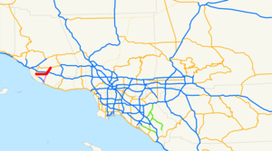
length_mi=13
length_round=0
length_ref= [ [http://www.dot.ca.gov/hq/structur/strmaint/brlog2.htm January 1, 2006 California Log of Bridges on State Highways] ]
direction_a=West
terminus_a=jct|state=CA|SR|1 in Oxnard
junction=jct|state=CA|US|101 in Camarillo
direction_b=East
terminus_b=jct|state=CA|SR|118 at Somis
previous_type=SR
previous_route=33
next_type=SR
next_route=35State Route 34 is a short
state highway in theU.S. State ofCalifornia . This route is part of theCalifornia Freeway and Expressway System [http://www.leginfo.ca.gov/cgi-bin/displaycode?section=shc&group=00001-01000&file=250-257 CA Codes (shc:250-257)] ] .Route description
It starts on the west at the intersection of "Oxnard Boulevard" (Route 1) and "Fifth Street" in Oxnard. It continues east then northeast on "Fifth Street" until it intersects "Pleasant Valley Rd" in Camarillo. After continuing east on Pleasant Valley Road a short distance, it turns north onto "Lewis Road" until the intersection with Las Posas Road at the north city limit of Camarillo where Route 34 continues straight ahead on "Somis Road". It ends at Route 118 near Somis. This route originally began in Port Hueneme, but in
1965 , the portion from Port Hueneme to Route 1 was deleted. Nevertheless, Route 34 mileposts add on these additional convert|4|mi|km along the signed route.Future plans
According to the 2003 Caltrans District 7 Master System Plan Status [http://www.cahighways.org/maps/2003scstatus.pdf Map] , the segment of California Route 34 on Fifth Street and Pleasant Valley Road will be relocated to a north-south alignment beginning near Calleguas Creek opposite the Naval Air Weapons Station, Point Mugu on California Route 1 and ending near the intersection of Lewis and Pleasant Valley roads.
External links
* [http://www.cahighways.org/033-040.html#034 California Highways: SR 34]
* [http://www.cahighways.org/maps/2003scstatus.pdf 2003 Caltrans District 7 Master System Plan Status Map]References

Wikimedia Foundation. 2010.