- Villarrica (volcano)
-

View of Villarrica Lake and the eponymous volcanoElevation 2,847 m (9,341 ft) Listing Region high point
UltraTranslation Place of Wealth (Spanish) Location Location Southern Chile Range Andes Coordinates 39°25′S 71°56′W / 39.42°S 71.93°W Geology Type Stratovolcano Age of rock < Upper Pleistocene Volcanic arc/belt South Volcanic Zone Last eruption 2011 Climbing First ascent 1883, Chilean Army Easiest route Villarrica ski centre - Piedra Negra 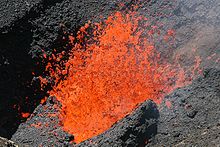 Lava fountain within Villarrica's crater.
 Aerial view of Mount Villarrica.
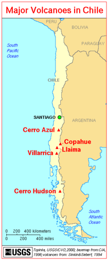 Map showing Chile's most active volcanoes.
 Satellite image of Volcan Villarrica.
Villarrica is one of Chile's most active volcanoes, rising above the lake and town of the same name. The volcano is also known as Rucapillán, a Mapuche word meaning "House of the Pillán". It is the westernmost of three large stratovolcanoes that trend perpendicular to the Andean chain along the Gastre Fault. Villarrica, along with Quetrupillán and the Chilean portion of Lanín, are protected within Villarrica National Park. Ascents of the volcano are popular with several guided ascents reaching the top during summer.
Villarrica, with its lava of basaltic-andesitic composition, is one of only five volcanoes worldwide known to have an active lava lake within its crater. The volcano usually generates strombolian eruptions, with ejection of incandescent pyroclasts and lava flows. Melting of snow and glacier ice as well as rainfalls often cause massive lahars (mud and debris flows), such as during the eruptions of 1964 and 1971.
Contents
Geography and Geology
Villarica's symmetrical edifice stands in the Chilean Central Valley as the westernmost of an alignment of three large stratovolcanoes. The alignment is attributed to the existence of an old fracture in the crust, the North West-West trending sinistral Gastre Fault Zone, the other volcanoes in the chain Quetrupillán and Lanín are far less active. This alignment is unusual as it crosses the N-S running Liquiñe-Ofqui Fault, around which most currently active volcanoes are aligned. Currently the volcano covers up an area of 400 km2 and has a volume 250 km3 according to estimates.[1]
About 25 scoria cones dot Villarica's flanks. It also has volcanic caves. The constant degassing at the lava lake turns Villarrica's otherwise quite effusive lava more viscous, heightening its explosive potential. Two large ignimbrite layers are visible around the volcano; the Licán Ignimbrite and later the Pucón Ignimbrite.
Villarrica emerged as a volcano during the Middle Pleistocene and grew forming a large stratocone of similar dimensions to the current edifice. 100 thousand years ago during the Valdivia Interglacial the ancestral Villarrica collapsed following an eruption and formed a large elliptical caldera of 6.5 and 4.2 km in diameter. During the Llanquihue Glaciation (Last Glaciation) Villarrica produced pyroclastic flow deposits, subglacial andesite lavas and dacite dykes. The volcano collapsed once again 13,700 years ago forming a new smaller caldera, among other pyroclastic flows the Licán Ignimbrite has been related to this event. Beginning with the Licán Ignimbrite, generated just after the last deglaciation, activity continued in similar fashion. The Pucón Ignimbrite was ejected during a minor collapse the uppermost stratocone 3,700 years ago.[2]
Glaciers
The upper part of Villarrica is permanently covered by snow and has some 40 km2 of glaciers.[3][4] The largest glacier of Villarrica is the Pichillancahue-Turbio Glacier situated on its southeastern flank, which has the most favorable environment for glacier formation. Ashfalls from the frequent eruptions of the volcano do sometimes enhance ablation due to increased absorption of solar radiation. Some ash coverings around Villarrica are thicker than 5 cm and insulates the glacier decreasing ablation instead of enhancing it. Between 1961 and 2003, Villarrica lost 25% of its glaciated surface. During the same period glaciers shrunk at an average rate of -0.4 km2 each year.[5]
Tourism
Villarrica is one of the world's most climbed stratovolcanoes. Guided hikes to the crater are offered from the town of Pucón by several enterprises, but may ascent might be suspended due to cloudiness and in periods of seismic or increased volcanic activity. Helicopter sightseeing services offer flights over the crater as well. In the winter (July-September) a ski resort operates on the northern slopes.
Eruptive history
Villarrica is one of Chile's most active volcanoes and has had recorded eruptions even since the time of the conquest of Chile and the founding of the city of Villarrica at its foothills in 1552. As in the case of other volcanoes in southern Chile eruptive record uncertainties exists in the first half of the 17th century due to the surrender or abandonment of Spanish settlements during the destruction of the Seven Cities. The earliest registered eruption was recorded in 1558. Since then, there have been at least 65 eruptions with assumed Volcanic Explosivity Indexes of magnitude 1 or 3.
1964 eruption
 A view from downtown Pucón
The two last weeks of February in 1964 the volcano showed signs of unrest, such as small but still violent lava effusions followed by temblors. On March 1 at 2:45 am the volcano begun a strombolian eruption. Dwellers at Coñaripe, a wood-logger town, woke up in the night and fled to the surroundings hills while it was raining after hearing strong noises and temblors. As the volcano was capped by an early autumn snowfall to its foothills[citation needed] the melting for snow and ice from Pichillancahue-Turbio Glacier produced together with the heavy rainfalls several lahars. Coñaripe, then located on the northwestern shores of Calafquén Lake, had about half of its buildings destroyed and was later reconstructed further east.
1971 eruption
On October 29, 1971, at 4:00 am, several explosions were heard from the crater, according to skiers and staff working at the Villarrica ski resort on the slope of the volcano. The same day a small column of white smoke was seen at the top of the volcano and later the same day the white column alternated with black smoke. One month later on December 29, quarter to midnight, Villarrica begun a new eruptive cycle. Pyroclasts were ejected and the snow surrounding the crater and on some parts of the slopes melted due to the heat. This was followed by a brief halt in activity followed by the opening of a new vent in the northeast flank through which lava went out. The lava flows melted considerable amounts of water, causing several lahars that went down through the troughs and valleys of the volcanic edifice. The lahars affected the localities of Pichaye, El Turbio, Collentañe, Minetué, Molco, Voipir and Curarrehue, all of them in the Trancura River's basin. In the larger settlements of Villarrica and Pucón, toxic sulphurous gases from the volcano turned the air unbreathable for moments. At least 15 people are reported to have died because of the eruption.[6]
See also
References
- ^ Volcán Villarrica OVDAS
- ^ Sterns et al. The Geology of Chile. Editors: Teresa Moreno and Wes Gibbons.
- ^ [1] Southern Andean Volcano Observatory
- ^ [2]
- ^ Rivera, A., Acuña, C. and Casassa, G. Glacier variations in central Chile (32°S-41°S). Chapter in Glacier science.
- ^ La erupción de 1971, Villarrica Volcano Visual Observation Project. 2008.
- "Villarrica". Global Volcanism Program, Smithsonian Institution. http://www.volcano.si.edu/world/volcano.cfm?vnum=1507-12=.
External links
- Satellite photo of Villarrica Volcano
- Villarrica Volcano info on SummitPost.com
- top of the volcano ...
- Villarrica Volcano Visual Observation Project
Andean volcanoes Northern Volcanic Zone (6° N–3° S) Nevado del Ruiz · Nevado del Huila · Galeras · Cayambe · Reventador · Pichincha · Antisana · Illiniza · Cotopaxi · Quilotoa · Tungurahua · SangayCentral Volcanic Zone (15°–27° S) Ampato · Coropuna · Sabancaya · Chachani · El Misti · Ubinas · Huaynaputina · Parinacota · Irruputuncu · Azufre · Sairecabur · Pacana · Licancabur · Lascar · Llullaillaco · Galán · San Francisco · Ojos del SaladoSouthern Volcanic Zone (33°–46° S) Tupungato · Tupungatito · Maipo · Calabozos · Descabezado Grande · Cerro Azul · Nevado de Longaví · Nevados de Chillán · Antuco · Copahue · Callaqui · Lonquimay · Llaima · Sollipulli · Villarrica · Quetrupillán · Lanín · Mocho-Choshuenco · Carrán-Los Venados · Puyehue-Cordón Caulle · Osorno · Calbuco · Hornopirén · Michinmahuida · Chaitén · Corcovado · Cay · Macá · HudsonAustral Volcanic Zone (49°–55° S) Note: volcanoes are ordered by latitude from north to southCategories:- Active volcanoes
- Stratovolcanoes of Chile
- Mountains of Chile
- VEI-5 volcanoes
- Ski areas and resorts in Chile
- Volcanoes of Los Ríos Region
- Volcanoes of Araucanía Region
- South Volcanic Zone


Wikimedia Foundation. 2010.