- Municipality of Lane Cove
-
Municipality of Lane Cove
New South Wales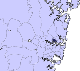
Population: 32,501(2009)[1] • Density: 3055/km² (7,912.4/sq mi) Area: 11 km² (4.2 sq mi) Mayor: Ian Longbottom Council Seat: Lane Cove Region: Metropolitan Sydney State District: Lane Cove, Willoughby, North Shore Federal Division: North Sydney LGAs around Municipality of Lane Cove: City of Ryde City of Willoughby City of Willoughby City of Ryde Municipality of Lane Cove North Sydney Council Municipality of Hunter's Hill City of Canada Bay Municipality of Leichhardt/City of Sydney  Lane Cove council office
The Municipality of Lane Cove is a Local Government Area located about 10km north-west of the central business district of Sydney, Australia, in the south-west corner of the North Shore. The Lane Cove River borders its south, with the eastern part of Hunter's Hill just across that river. It extends westward to Ryde, with Willoughby to the north and North Sydney to the east.
Contents
Demographics
According to the Australian Bureau of Statistics [2], there:
- were 32,375 people as at 30 June 2006, the 66th largest Local Government Area in New South Wales. It was equal to 0.5% of the New South Wales population of 6,827,694
- was an increase of 89 people over the year to 30 June 2006, the 89th largest population growth in a Local Government Area in New South Wales. It was equal to 0.2% of the 58,753 increase in the population of New South Wales
- was, in percentage terms, an increase of 0.3% in the number of people over the year to 30 June 2006, the 115th fastest growth in population of a Local Government Area in New South Wales. In New South Wales the population grew by 0.9%
- was an increase in population over the 10 years to 30 June 2001 of 1,048 people or 3.3% (0.3% in annual average terms), the 85th highest rate of a Local Government Area in New South Wales. In New South Wales the population grew by 622,966 or 10% (1.0% in annual average terms) over the same period.Suburbs
Suburbs in the municipality are:
- Greenwich
- Lane Cove
- Lane Cove North
- Lane Cove West
- Linley Point
- Longueville
- Northwood
- Riverview
- St Leonards
Localities in the municipality are:
- Blaxlands Corner
- Gore Hill
- Osborne Park
Council
Lane Cove Municipal Council is composed of nine councillors elected proportionally. The municipality is divided into three wards, each electing three councillors. The mayor is not directly elected.[3] The current makeup of the council is as follows:[3]
Party Councillors Liberal Party of Australia 4 Independents 3 The Greens 2 Total 9 The current council, elected in 2008, is:[3]
Ward Councillor Party Notes Central Ward Ann Smith Liberal Shauna Forrest Greens Scott Bennison Liberal East Ward David Brooks-Horn Liberal Pam Palmer Independent Ron Tudge Independent West Ward Win Gaffney Liberal Ian Longbottom Independent Mayor Keith McIlroy Greens Notable former or current residents
- Nicole Kidman - Lived in Greenwich
- Dr. Anthony David Kidman - father to Nicole Kidman, doctor
- Lachlan Bennett - semi-famous architect
- Brett Whiteley - artist
- Lloyd Rees - artist
References
- ^ Australian Bureau of Statistics (30 March 2010). "Regional Population Growth, Australia, 2008–09". http://www.abs.gov.au/ausstats/abs@.nsf/Latestproducts/3218.0Main%20Features42008-09?opendocument&tabname=Summary&prodno=3218.0&issue=2008-09&num=&view=. Retrieved 3 June 2010.
- ^ "Regional Population Growth, Australia, 2005-06 (catalogue no.: 3218.0)". Australian Bureau of Statistics. http://abs.gov.au. Retrieved 2007-03-12.
- ^ a b c "Lane Cove Municipal Council". 2008 Election results. Electoral Commission NSW. http://www.lg.elections.nsw.gov.au/LGE2008/result.Lane_Cove.html. Retrieved 2009-08-02.[dead link]
External links
- Lane Cove Municipality Council website
- Lane Cove at the Open Directory Project
- 2001 Census Information
Regions of Sydney Local Government Areas of Sydney Ashfield · Auburn · Bankstown · Blacktown · Botany Bay · Burwood · Camden · Campbelltown · Canada Bay · Canterbury · Fairfield · The Hills · Holroyd · Hornsby · Hunter's Hill · Hurstville · Kogarah · Ku-ring-gai · Lane Cove · Leichhardt · Liverpool · Manly · Marrickville · Mosman · North Sydney · Parramatta · Penrith · Pittwater · Randwick · Rockdale · Ryde · Strathfield · Sutherland · City of Sydney · Warringah · Waverley · Willoughby · WoollahraList of Sydney suburbs Local Government Areas of New South Wales Metropolitan Sydney Inner SydneyAshfield · Botany Bay · Burwood · Canada Bay · Canterbury · Hurstville · Kogarah · Lane Cove · Leichhardt · Manly · Marrickville · Mosman · North Sydney · Randwick · Rockdale · Strathfield · Sydney · Waverley · Willoughby · WoollahraOuter SydneyAuburn · Bankstown · Blacktown · Camden · Campbelltown · Fairfield · The Hills · Holroyd · Hornsby · Hunter's Hill · Ku-ring-gai · Liverpool · Parramatta · Penrith · Pittwater · Ryde · Sutherland · WarringahSydney SurroundsMid North Coast Bellingen · Clarence Valley · Coffs Harbour · Greater Taree · Kempsey · Nambucca · Port Macquarie-Hastings · Lord Howe IslandMurray Murrumbidgee Carrathool · Coolamon · Cootamundra · Griffith · Gundagai · Hay · Junee · Leeton · Lockhart · Murrumbidgee · Narrandera · Temora · Wagga WaggaHunter Cessnock · Dungog · Gloucester · Great Lakes · Lake Macquarie · Maitland · Muswellbrook · Newcastle · Port Stephens · Singleton · Upper HunterIllawarra Richmond Tweed Southeastern Bega · Bombala · Boorowa · Cooma-Monaro · Eurobodalla · Goulburn Mulwaree · Harden · Palerang · Queanbeyan · Snowy River · Tumut · Upper Lachlan · Yass Valley · YoungNorthern Armadale Dumaresq · Glen Innes-Severn · Gunnedah · Guyra · Gwydir · Inverell · Liverpool Plains · Moree Plains · Narrabri · Tamworth · Tenterfield · Uralla · WalchaCentral West North Western Far West Categories:- Local Government Areas in Sydney


Wikimedia Foundation. 2010.