- Ogden-Hinckley Airport
-
Ogden-Hinckley Airport 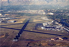
IATA: OGD – ICAO: KOGD Summary Airport type Public Operator Ogden City Corp. Location Ogden, Utah Elevation AMSL 4,473 ft / 1,363.4 m Coordinates 41°11′45.3″N 112°00′43.8″W / 41.195917°N 112.012167°WCoordinates: 41°11′45.3″N 112°00′43.8″W / 41.195917°N 112.012167°W Runways Direction Length Surface ft m 3/21 8,103 2,470 Asphalt 7/25 5,600 1,707 Asphalt 16/34 5,195 1,583 Asphalt Ogden-Hinckley Airport (formerly Ogden Municipal Airport) (IATA: OGD, ICAO: KOGD) is a public airport located three miles (5 km) southwest of the city of Ogden in Weber County, Utah, U.S. It is billed as "Utah's Busiest Municipal Airport" and was a filming location for the 1997 film Con Air.
Contents
History
During World War II the airfield was used by the United States Army Air Force. The airport serves general aviation aircraft consisting of private and business aircraft, charters, sight-seeing, air ambulance, and flight training. Although the airport is capable of handling larger passenger aircraft, the airport currently has no scheduled airline flights. The closest airport with scheduled airline flights is Salt Lake City International Airport, located approximately 30 miles south. In the event the Salt Lake City International Airport closes or has to turn away aircraft due circumstances such as weather conditions below landing minimums, Ogden-Hinckley is capable of accepting diverted commercial flights.
The airport is served by an FAA control tower with radar approach services provided by Salt Lake City TRACON.
Accidents and incidents
On 18 December 1953, a United States Air Force B-29 Superfortress scheduled to land at Hill Air Force Base landed at Ogden Municipal Airport by mistake.[1] One of the eight crew was killed when the aircraft crashed and caught fire.[2]
Culture and media
The airfield was a filming location for the 1997 film Con Air.[citation needed]
See also
References
- ^ "The Legacy of Douglas Corrigan: "Wrong Way" Landings By Commercial Airliners". Third Amendment. http://www.thirdamendment.com/wrongway.html. Retrieved 25 December 2009.
- ^ "B-29 CRASHES IN SMOG; Calls One Utah Field, Cracks Up at Another -- 1 Dead, 7 Hurt". New York Times. 19 December 1953. http://select.nytimes.com/gst/abstract.html?res=F10B17FC395A107B93CBA81789D95F478585F9. Retrieved 25 December 2009.
External links
- Ogden-Hinckley Airport
- Resources for this airport:
- AirNav airport information for KOGD
- ASN accident history for OGD
- FlightAware airport information and live flight tracker
- NOAA/NWS latest weather observations
- SkyVector aeronautical chart, Terminal Procedures for KOGD
Categories:- Airports in Utah
- Ogden, Utah
- Airfields of the United States Army Air Forces in Utah
- Buildings and structures in Weber County, Utah
- Transportation in Weber County, Utah

Wikimedia Foundation. 2010.