- Nova Scotia Highway 105
-
Highway 105
Mabel and Alexander Graham Bell Way
Trans-Canada HighwayRoute information Maintained by Nova Scotia Department of Transportation and Infrastructure Renewal Length: 142 km[citation needed] (88 mi) Existed: 1970[citation needed] – present Major junctions West end: 

 Hwy 104 (TCH) / Trunk 4 / Trunk 19 near Port Hawkesbury
 Hwy 162 near Bras d'Or
 Hwy 125 to Sydney
East end: North Sydney Ferry Terminal Highway system Provincial highways in Nova Scotia
← Hwy 104 (TCH)Hwy 106 (TCH)  →
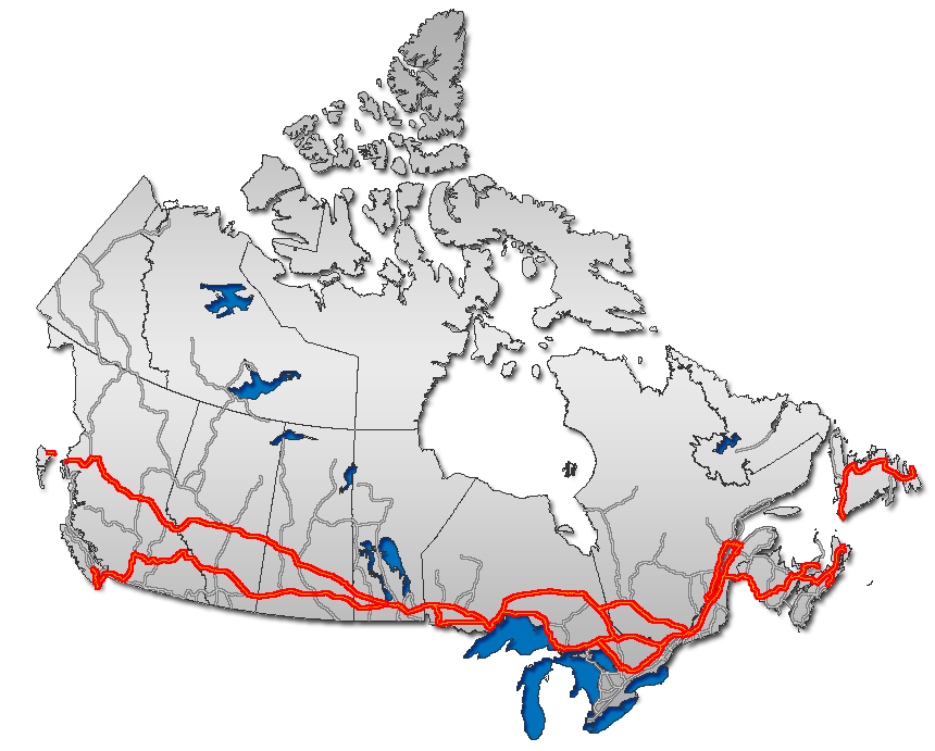
→Highway 105 in Nova Scotia represents the Cape Breton Island leg of the Trans-Canada Highway. It runs from the junction just east of the Canso Causeway in Port Hastings to the Marine Atlantic ferry terminal in North Sydney, representing a distance of 142 kilometres (88 mi).
In 2010, the provincial government named the entire highway Mabel and Alexander Graham Bell Way in honour of Mabel Gardiner Hubbard and her husband Alexander Graham Bell, who resided and are buried at Beinn Bhreagh near Baddeck.[1]
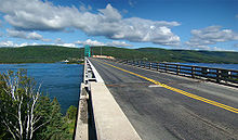 Seal Island Bridge on Highway 105
The highway travels northeast from Port Hastings along the base of a group of mountains known as Big Ridge to Whycocomagh. It then follows the north shore of Bras d'Or Lake, bypassing Baddeck on a controlled access segment. Still running in a general northeast direction, the highway ascends and descends a number of hills, before reaching the peak of Kelly's Mountain. Highway 105 descends using a series of sharp turns, and crosses the Great Bras d'Or of Bras d'Or Lake on the Seal Island Bridge. The road then runs east through the villages of Bras d'Or and Florence, and has controlled access for the final three kilometres to its end at the Marine Atlantic ferry terminal in North Sydney, where travellers can continue to Newfoundland.
With some minor exceptions, the highway is two lanes and uncontrolled access, with some traffic lights in the Florence area.
The Cabot Trail, which is usually used to describe a different road, is signed along a portion of Highway 105 so that the signed route forms a loop.
Highway 105 is descended from the former Trunk 5, which no longer exists; Highway 105 follows the old Trunk 5 alignment, with Routes 205, 305 and Old Route 5 following areas bypassed by Highway 105. The 105 name was applied in 1970.
List of interchanges
Location Exit km Intersecting Roads Notes Port Hastings 1 0 Highway 104,  Trunk 4,
  Trunk 19
Canso Causeway, Fleur-de-Lis Trail, Ceilidh Trail Kingsville 2 18 Riverside Road at-grade Melford 3 31 River Denys Road at-grade Iron Mines 4 42 Orangedale Road at-grade (Bras d'Or Lakes Scenic Drive) Whycocomagh [1] 5 47 Route 395 at-grade Little Narrows 6 58 Route 223 at-grade (Bras d'Or Lakes Scenic Drive) Buckwheat Corner 7 76 Cabot Trail at-grade Baddeck 8 83 Route 205 at-grade Baddeck 9 85 Riverside Road MacAulays Hill 10 94 Route 205 at-grade South Haven 11 103 Cabot Trail at-grade Englishtown 12 107 Route 312 at-grade Big Bank 13 120 Kempt Head Road at-grade, end of Seal Island Bridge Boularderie East 14 122 Old Trunk 5 at-grade New Dominion 15 126 St. James Road at-grade Millville Boularderie 16 132 Millville Road at-grade Bras d'Or 17 135  Highway 162
at-grade Bras d'Or / Florence 18 136 Route 305, Church Road at-grade Florence 19 138 Park Road at-grade Sydney Mines 20 139  Highway 125, Main Street
North Sydney 21 142 Route 305 (Queen Street) References
Preceded by
Highway 104Trans-Canada Highway
Highway 105Succeeded by
NL Route 1 Portions of the Trans-Canada Highway
 British Columbia: Highway 1 • Highway 5 • Highway 16 | Alberta: Highway 1 • Highway 16
Saskatchewan: Highway 1 • Highway 16 | Manitoba: Highway 1 • Highway 16 • Highway 100
Ontario: Highway 17 • Highway 69 • Highway 400 • Highway 12 • Highway 7 • Highway 71 • Highway 11 • Highway 66 • Highway 417
Quebec: Autoroute 40 • Autoroute 25 • Autoroute 20 • Autoroute 85 • Route 185 • Route 117 • Autoroute 15
New Brunswick: Route 2 • Route 16 | Confederation Bridge | Prince Edward Island: Route 1 | Nova Scotia: Highway 104 • Highway 105 • Highway 106
Newfoundland: Route 1 Category ·
  Portal ·
  WikiProject
Roads and highways in Nova Scotia 100-series Trunk Routes Collector roads 201 · 202 · 203 · 204 · 205 · 206 · 207 · 208 · 209 · 210 · 211 · 212 · 213 · 214 · 215 · 216 · 217 · 219 · 221 · 223 · 224 · 236 · 239 · 242 · 245 · 246 · 247 · 252 · 253 · 255 · 256 · 276 · 277 · 289 · 301 · 302 · 303 · 304 · 305 · 306 · 307 · 308 · 309 · 311 · 312 · 316 · 318 · 320 · 321 · 322 · 324 · 325 · 326 · 327 · 328 · 329 · 330 · 331 · 332 · 333 · 334 · 335 · 336 · 337 · 340 · 341 · 344 · 347 · 348 · 349 · 354 · 357 · 358 · 359 · 360 · 362 · 366 · 368 · 374 · 376 · 395Scenic routes Categories:- Nova Scotia provincial highways
- Trans-Canada Highway
- Limited-access roads in Canada
- Roads in the Cape Breton Regional Municipality
- Roads in Inverness County, Nova Scotia
- Roads in Victoria County, Nova Scotia

Wikimedia Foundation. 2010.