- Rancho Camulos
Infobox_nrhp2 | name =Rancho Camulos
nhl=yes
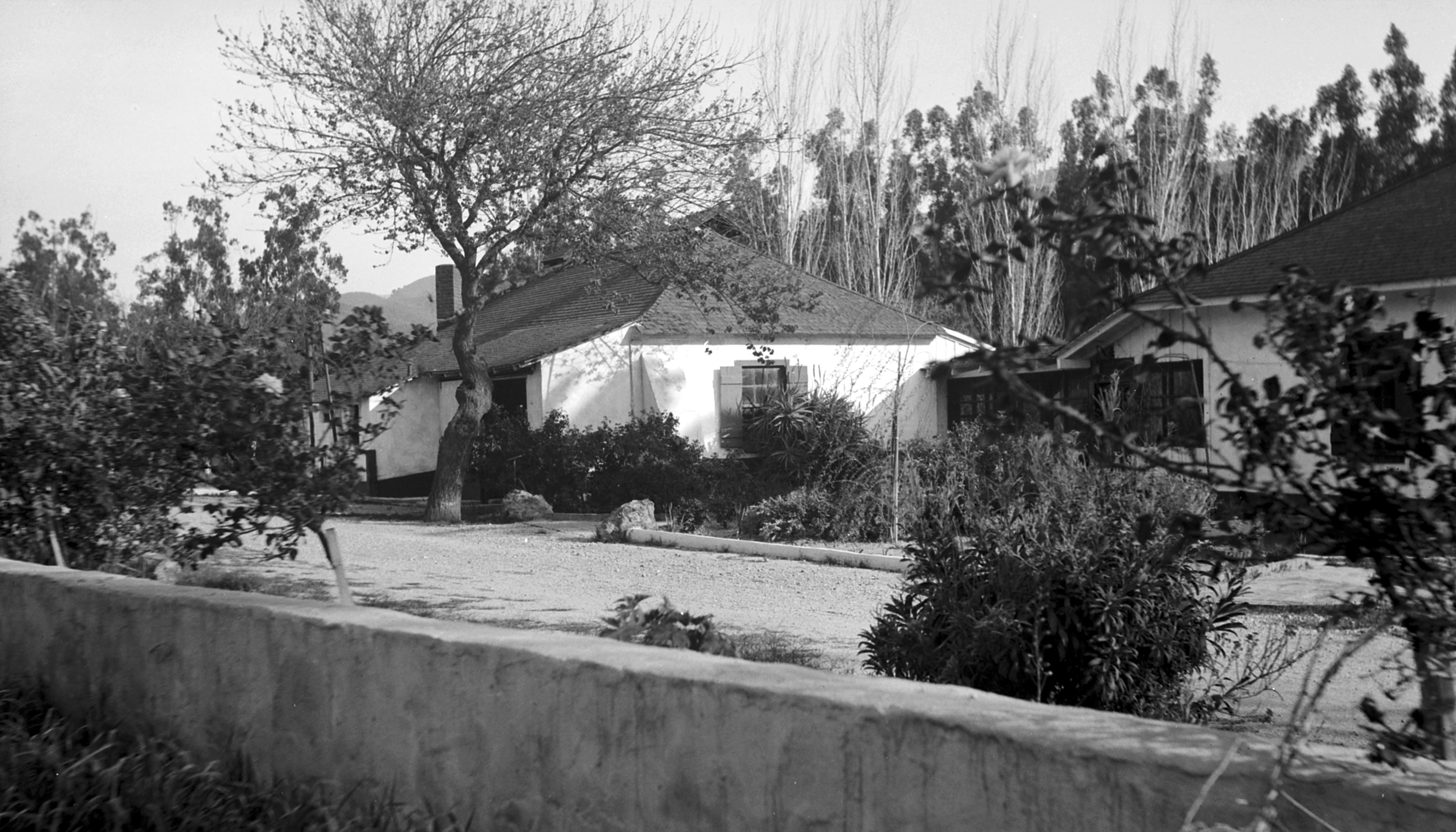
caption =A view of Rancho Camulos from the northwest.
location= 5164 East Telegraph Road,Piru, California
area =
lat_degrees = 34 | lat_minutes = 24 | lat_seconds = 20.34| lat_direction = N
long_degrees = 118 | long_minutes = 45 | long_seconds = 24 | long_direction = W
locmapin = California
built = 1853
architect=
architecture=Spanish Colonial , Mission/Spanish Revival
designated_nhl =February 16 ,2000 cite web|url=http://tps.cr.nps.gov/nhl/detail.cfm?ResourceId=328688969&ResourceType=Building
title=Rancho Camulos |accessdate=2008-01-27|work=National Historic Landmark summary listing
publisher=National Park Service]
added =November 1 ,1996 cite web|url=http://www.nr.nps.gov/|title=National Register Information System|date=March 15 ,2006 |work=National Register of Historic Places|publisher=National Park Service]
designated_other1_name = California Historic Landmark
designated_other1_date =
designated_other1_abbr = CHL
designated_other1_link = List of California Historical Landmarks
designated_other1_number = 553
designated_other1_color = #ffc94b
governing_body = Private
refnum=96001137Rancho Camulos, now known as Rancho Camulos Museum, is located convert|2.2|mi|km|1 east of
Piru, California . It was the home ofYgnacio del Valle , an "alcalde " of Los Angeles and member of theCalifornia State Assembly . The ranch was known as the Home of Ramona because it is likely that the popular 1884 novel "Ramona " byHelen Hunt Jackson was set there. The novel helped in raising awareness about theCalifornio lifestyle and "romanticizing of the mission and rancho era of California history."The convert|1800|acre|km2|0|sing=on working ranch is a prime example of an early California rancho in its original rural setting. It was the source of the first commercially grown oranges in what is now Ventura County, and is one of the few remaining
citrus growers inSouthern California .State Route 126 bisects the property, with most of the main buildings located south of the highway, and a few buildings on the north. The main
adobe is one of the few extant Spanish Colonial buildings left in the state. Most of the other buildings are done in Mission Revival or Spanish Colonial Revival, both of which are derivatives of the former.Rancho Camulos is designated a
National Historic Landmark , listed on theNational Register of Historic Places , and is also aCalifornia Historical Landmark . Many of the buildings and grounds are open to the public as amuseum of this period in California history.History
Originally a
Tataviam village named Kamulus (meaning "juniper "cite news | url=http://www.scvhistory.com/scvhistory/times111101.htm | title=Del Valle Family Played a Starring Role in Early California | publisher=Los Angeles Times | first=Cecilia | last=Rasmussen | date=November 11 ,2001 | accessdate=2007-04-09] ), the area was used byMission San Fernando Rey de España for growing crops and as a grazing area for livestock as early as 1804. The population of this relatively isolated area (only traversed by the El Camino Real), as recorded byWilliam Edward Petty Hartnell during his inspection of the mission, was 416 in 1839.cite web | url=http://www.scvhistory.com/scvhistory/camulos-nrhp3.htm | title=Rancho Camulos: National Register of Historic Places Nomination | first=Judith P. | last=Triem | coauthors=Stone, Mitch | publisher=San Buenaventura Research Associates | format=significance | accessdate=2007-04-13] It was included in the convert|48612|acre|km2|0|sing=onRancho San Francisco granted to Del Valle's father,Antonio del Valle , administrator of Mission San Fernando, by GovernorJuan B. Alvarado onJanuary 22 ,1839 , after the secularization of the missions.After Antonio's death in 1841, Ygnacio inherited Rancho San Francisco, but this was challenged in court by his father's second wife. Nevertheless, by 1853 he constructed a four-room
adobe house and acorral at Camulos. By 1857, the land title dispute was settled, with Ygnacio getting the western portion and the remainder was split among Antonio's children and his second wife. He purchased back some of the other portions from his family as well as the neighboringRancho Temescal to the north, and beganlivestock operations on the expanded area. However, Del Valle and his family did not live on the ranch initially, instead settling in house on what is nowOlvera Street in Los Angeles. The Del Valle family did not move back to Camulos, which he had expanded, until 1861. During this time, the ranch was overseen by José Antonio Salazar, Ygnacio's majordomo. Thus, despite its close association with "Ramona" and Mexican California, the house was constructed after California statehood and the family never lived there under Mexican rule.In the 1860s, a
drought forced Del Valle to sell off much of his land, but Camulos not only survived, but thrived.cite web | url=http://ranchocamulos.org/History/index.htm | title=Historical Overview | publisher=Rancho Camulos Museum | accessdate=2007-03-28] By the time of his death in 1880, the house had expanded to twenty rooms and the compound had become a self-sustaining ranch, complete with a brickwinery ,chapel ,barn and workers' housing. Records indicate that in 1870 the ranch was largestvintner in the area. Astagecoach line opened in 1874 and in 1887, Southern Pacific ran a rail line past the ranch, including a depot at Camulos, ending the ranch's isolation.In 1908, the Del Valle Company was incorporated by Ygnacio's children, but by 1924, the property was sold to August Rübel, a native of
Zürich ,Switzerland . Upon its sale, the "Los Angeles Times " lamented,Rübel continued operating the ranch in the same manner as the Del Valles, employing many of same workers. He had served in the
American Field Service duringWorld War I and whenWorld War II broke out, he volunteered for active duty again. However, he died while serving inTunisia in 1943. After his death, his wife Mary married a man named Edwin Burger, who was not as interested in maintaining the rancho. After Mary's death in 1968, Burger closed the ranch entirely, and the buildings and grounds were left untended for years. Rübel's heirs regained control of the property after the 1994Northridge earthquake , which had damaged a number of buildings on the rancho.The Rübel family restored commercial citrus production and set about repairing the earthquake damage. They successfully lobbied to have Camulos listed on the National Register of Historic Places in 1996. In 2000, it was further designated a National Historic Landmark.citation|title=PDFlink| [http://pdfhost.focus.nps.gov/docs/NHLS/Text/96001137.pdf National Historic Landmark Nomination: Rancho Camulos / Camulos Ranch, Del Valle Ranch, Camulos] |164 KiB |date=June 26, 1996 |author=Judy Triem, Mitch Stone, Edna E. Kimbro, and Kira Badamo |publisher=National Park Service and PDFlink| [http://pdfhost.focus.nps.gov/docs/NHLS/Photos/96001137.pdf "Accompanying 8 photos, from c.1890 and 1987"] |391 KiB ] Although the main house was restored in 1996, funding was not available to restore the smaller buildings until 2006. As a result, restoration efforts are currently taking place with construction completed in spring 2007. [cite news | url=http://www.latimes.com/news/local/la-me-rancho16sep16,1,1724642.story | title=Historic Ventura County Adobe to Undergo Restoration | publisher=
Los Angeles Times | first=Catherine | last=Saillant | date=September 16 ,2006 | accessdate=2006-09-25] The rancho is on State Route 126, but little is visible from the highway.Agricultural development
Del Valle acquired his first
Valencia orange seedlings in 1857 from his friendWilliam Wolfskill . The fruit from these trees was the first to be commercially grown in what is now Ventura County, although this was a relatively small scale because the crops had to be taken by wagon to Los Angeles. A Southern Pacific line opened in 1876 seventeen miles (27 km) to the east in Saugus, providing a more convenient form of transport.However, the primary agricultural product from Rancho Camulos was
wine . Ninety acres (360,000 m²) ofvineyard s were planted in the 1860s and Camulos wines and brandies were known throughout Los Angeles and Santa Barbara. In 1870, records indicate Camulos was largest of the four vintners in the San Buenaventura Township of Santa Barbara County, with 45 tons (40,900 kg) of grapes grown, making 6,000 US gallons (23,000 L) of wine and 800 US gallons (3,000 L) of brandy. In addition to oranges and grapes, the ranch producedalmond s,walnut s,apricot s,wheat ,corn andbarley .Rose petals grown at Camulos were shipped toEurope to makeperfume .cite journal | url=http://findarticles.com/p/articles/mi_m1216/is_6_211/ai_111354269 | title=More than just our home | journal=Sunset | month=October | year=2003 | first=Peter | last=Fish | accessdate=2007-04-19]Over the years, the vineyards were replaced by other fruits. Today, about convert|600|acre|km2|1 are under cultivation, most of it oranges, but
lemon s,grapefruit , andavocado s are grown too. This makes Camulos a rare instance of a surviving citrus operation. During the years 1920–45, the citrus industry experienced a period of great growth, and, in contrast to the natural desert-like conditions of the area, images of "citrus belts" help cement the image of Southern California as an idyllic farmland in the nation's eye.cite web | url=http://www.scvhistory.com/scvhistory/camulos-nrhp2.htm | title=Rancho Camulos: National Register of Historic Places Nomination | first=Judith P. | last=Triem | coauthors=Stone, Mitch | publisher=San Buenaventura Research Associates | format=narrative description | accessdate=2007-04-13] After World War II, urban development eliminated much of the Southern California citrus production, with the notable exception of the Santa Clara River Valley."Ramona"
"
Ramona ", published in 1884, was based in part of some of the experiences thatHelen Hunt Jackson had had during her visit to Rancho Camulos in 1882. Jackson only spent two hours on the ranch and did not meet with Ysabel del Valle, and yet she had a keen eye for details, many of which made it into the book. For example, the altar cloth in the rancho's chapel had a small tear in it which had been mended; in the story, Ramona accidentally tears the altar cloth and resews it together.DeLyser, p. 70] The book became extremely popular and inspired a great deal of tourism, which happened to coincide with the opening of Southern Pacific railroad lines in Southern California.With all of the interest generated by the book, a number of communities declared that they were the setting for the novel in order to cash in on the boom, most notably Rancho Guajome in San Diego County, where Jackson had also visited prior to the book's publication.cite web | url=http://www.scvhistory.com/scvhistory/hs3001.htm | title="Home of Ramona: Cover" | publisher=
Santa Clarita Valley Historical Society | accessdate=2007-04-09] However, the location of the fictional Moreno Ranch, "midway in the valley [between lands] to the east and west, which had once belonged to the Missions of San Fernando and San Bonaventurasic" [cite book | url=http://www.gutenberg.org/etext/2802 | title=Ramona | first=Helen Hunt | last=Jackson | authorlink=Helen Hunt Jackson | year=1884] corresponds to the location of Rancho Camulos, and the physical description of some of the buildings on the fictional ranch accurately describe actual buildings at Camulos.cite web | url=http://ranchocamulos.org/Ramona/index.htm | title=The Ramona Story | publisher=Rancho Camulos Museum | accessdate=2007-03-28] On the other hand, relative to the other locations in the novel (Ramona's having been married in San Diego and Alessandro's family being from the Temecula area), Camulos seems too distant to be the real location. [DeLyser, p. 89] Unfortunately, Jackson died in 1885, never having publicly disclosed what locations the book was based on. Historians today are unsure whether Moreno Ranch actually represented a real location.cite news | title=Myth of Ramona revived in Ventura | url=http://www.scvhistory.com/scvhistory/sg103098d.htm | first=Leon | last=Worden | publisher=The Signal | date=October 30 ,1998 | accessdate=2007-04-13]Nevertheless, by 1886, the ranch was already considered the setting of the novel. Edward Roberts published an article entitled, "Ramona's Home: A Visit to the Camulos Ranch, and to the Scenes Described by 'H.H.'" in the May 13, 1886 edition of the "
San Francisco Chronicle ". Significantly, he was one of the first to publish an account that blended fact and fiction. The inclusion of his article as an appendix to later versions of the novel only served to cement that association.The first book solely devoted to "Ramona" and the ranch was published in 1888 by
Charles Fletcher Lummis , a close friend of the Del Valles and who had fallen in love with the teenage Susana Carmen (nicknamed "Susanita") del Valle. Lummis took photographs of the buildings and published them in his own book, "Home of Ramona: Photographs of Camulos, the fine old Spanish Estate Described by Mrs. Helen Hunt Jackson as the Home of "Ramona". He made it clear that the Del Valles were nothing like the fictional Morenos, who treated Ramona poorly, but he too would mix fact with fiction with such statements as, " [the veranda] is about a hundred feet in length and runs from the door of Father Salvierderra's room to that of Ramona's room." [Lummis (1888), as quoted in DeLyser, p. 74]Lummis's goal was to discourage the novel's association with other properties, as was
Adam Clark Vroman 's "Ramona Illustrated: The Genesis of the Story of Ramona", which compared photographs of the rancho's buildings and environs with text from the novel, as well as photographs from competing locations.George Wharton James 's 1909 "Through Ramona's Country" declared that Camulos was the "avowed and accepted home of the heroine." [cite book | title=Through Ramona's Country | first=George Wharton | last=James | year=1909 | publisher=Little, Brown and Company | page=107 | url=http://books.google.com/books?id=ikNIAAAAMAAJ&printsec=frontcover&dq=through+ramona%27s+country#PPA107,M1]Despite the lack of easy access to the ranch and any lodging in the area, tourists flocked to it, and the 1887 establishment of the Southern Pacific line only served to increase that number, with the railroad featuring the ranch in its advertisements in order to distinguish it from its competitors. Although the ranch was not developed for tourism, the Del Valles, with their Californio sense of hospitality, would lodge the visitors, but by October 1888, it was getting to be so expensive for the family that Reginaldo del Valle pressed upon his mother to stop being so hospitable. [DeLyser, p. 77] The tourists themselves would also be quite a nuisance, and uncouth visitors would steal items from the house as souvenirs, or help themselves to fruit from the orchards. [DeLyser, p. 79] By
Naturally, the name Camulos became so tied to the novel that many people began to use it instead of the original "Moreno Ranch" when referring to the novel. An 1897 play based on the book was called, "Ramona, or the Bells of Camulos". In
Virginia Calhoun 's 1905 stage adaptation, characters in the play called the ranch Camulos as well. [DeLyser, p. 80]Given the general belief that Camulos was indeed the original setting,
D. W. Griffith shot portions of his 1910 silent film at the rancho, using the chapel, the adobe and patio, and the nearby mountains as backdrops. Paintings and photographs by noted artists such as Adam Clark Vroman,Henry Chapman Ford , andAlexander Harmer of the rancho also illustrated later versions of the novel.Although tourism brought much difficulty to the Del Valles, they were not above capitalizing upon their newfound fame themselves,
brand ing their wine and oranges the "Home of Ramona Brand", with their label using the same view of the veranda that had been popularized in postcards. One Tataviam servant girl apparently also made quite a bit of money by pretending to be the real Ramona and charging tourists for a photograph. [DeLyser, p. 82]Tourists continued to arrive even after the SP relocated their main line through the
Santa Susana Pass in 1903. Two daily trains made stops at Camulos until the service was discontinued in the 1940s and tourism by automobile became commonplace at this time. After the Rübels took ownership in 1924, they continued to welcome visitors in small numbers, converting the second floor of the winery into a small museum with artifacts from the Del Valle family.Grounds
There are fifteen buildings open to the public as part of the Rancho Camulos Museum, all of were built before 1930 and are still in their original locations. They are mostly built in Spanish Colonial or Mission Revival styles (the latter is derived from the former), but later buildings were done in differing
architectural style s, more representing the period in which they were built.Landscaping features such aslawn s, flower gardens, ornamental trees, and walkways separate the residential areas from the working portions of the ranch.The main adobe, also called the Ygnacio del Valle adobe, is a 10,000 square foot (929 m²), twenty-room, U-shaped structure. When initially constructed in 1853, it was an L-shaped four-room house connected with an external "corredor" (as opposed to an interior
hallway ), as is typical of the Spanish Colonial style. It is unusual for its time period because around this time, the Monterey style was in vogue, as is evidenced by contemporaneous buildings in Santa Barbara.Rancho Los Alamos in Santa Barbara County,Rancho Guajome in Oceanside, andRancho Las Flores in Santa Barbara, all National Historic Landmarks, are built in a similar vein.The house expanded in several phases. In 1861 before the Del Valle family moved here permanently three additional rooms were added as well as a free-standing "cocina" (kitchen). A basement was installed under the new rooms as well. In the 1870s, another wing was added perpendicular to the 1861 attachment. Finally some time after 1895, one more room was added to the new wing, as well as a
breezeway to the kitchen, completing the current shape. Further remodeling done after this time was to the interior only.The basement of the house initially served as the wine storage area, but in 1867, a one-and-a-half-story
brick winery was constructed. After 1900, when wine grapes were no longer grown commercially, this building served as a storage room. Rübel later converted it to a museum for "Ramona" visitors, complete with Del Valle family artifacts. Currently it is used for farm equipment and automobile storage.To the west of the main house is a large
California Black Walnut tree that was most likely planted by Juventino del Valle in the 1860s. It measures 25 feet (7.6 m) in circumference and its branches spread out almost half an acre (2,000 m²). It is believed to be the largest Black Walnut tree in the area.The wooden
chapel was constructed around 1867, replacing a makeshift chapel that had been set up in 1861. After the secularization of the missions, this chapel became known as the "lost mission", the only place of worship between Mission San Fernando andMission San Buenaventura . Directly to the northwest of the chapel is a bell structure containing two bells on a freestanding frame, which were used to call worshipers to Mass. These were cast atKodiak, Alaska , and one had previously been used at Mission San Fernando. A third bell was removed by one of the Del Valle daughters and is missing.The exact dates of construction of the barn, gas station, and bunkhouse are unknown, but the
American Craftsman style of architecture indicates it was between 1910 to 1916. The barn is located to the northwest of the living quarters, in the main work area. The gas station and bunkhouse are not depicted on the map.The small adobe, next to the highway, was built by Nachito del Valle. This Spanish Colonial Revial house was constructed around 1920 and was damaged severely in the 1994 earthquake. After its reconstruction, it will serve as the museum's visitor center.
The schoolhouse, constructed in 1930, was the last to be built on the property. It was built by Rübel for his and his bookkeeper's families and designed to match the main adobe.
There are few buildings left on the north side of the highway. The most notable are the wooden Southern Pacific
saltbox -style section house and workers' bunkhouse, both built in 1887. A train depot andpost office both used to exist, but have been torn down. Finally, three farmworkers'bungalow s, built by the Del Valle family in 1916, sit west of the section house.Historic designations
*United States
National Historic Landmark — addedFebruary 16 2000
*United StatesNational Register of Historic Places — reference number 96001137, addedNovember 1 1996
*California Historical Landmark — number 553cite web | url=http://ohp.parks.ca.gov/default.asp?page_id=21535 | title=Ventura | work=California Historical Landmarks | publisher=Office of Historic Preservation | accessdate=2005-08-26]Further reading
*cite book | title=Ramona Memories: Tourism and the Shaping of Southern California | first=Dydia | last=DeLyser | chapter=Rancho Camulos: Symbolic Heart of the Ramona Myth | pages=65–84 | publisher=University of Minnesota Press | year=2005 | id=ISBN 0816645728 | url=http://books.google.com/books?id=L9Y4gQMMKP8C&pg=PA78&dq=%22rancho+camulos%22&sig=ACfU3U2s7B3MpWNBcje7YeZzv85JCLZ6XQ#PPA67,M1
ee also
*
List of Registered Historic Places in Ventura County, California References
External links
* [http://www.ranchocamulos.org/ Rancho Camulos Museum web site]
* [http://www.scvhistory.com/scvhistory/camulos.htm Rancho Camulos] , Santa Clarita Valley Historical Society
Wikimedia Foundation. 2010.