- Tiwanaku
-
Tiwanaku: Spiritual and Political Centre of the Tiwanaku Culture * UNESCO World Heritage Site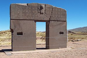
Country Bolivia Type Cultural Criteria iii, iv Reference 567 Region ** Latin America and the Caribbean Inscription history Inscription 2000 (24th Session) * Name as inscribed on World Heritage List
** Region as classified by UNESCOCoordinates: 16°33′17″S 68°40′24″W / 16.55472°S 68.67333°W Tiwanaku (Spanish: Tiahuanaco and Tiahuanacu) is an important Pre-Columbian archaeological site in western Bolivia, South America. Tiwanaku is recognized by Andean scholars as one of the most important precursors to the Inca Empire, flourishing as the ritual and administrative capital of a major state power for approximately five hundred years. The ruins of the ancient city state are near the south-eastern shore of Lake Titicaca in the La Paz Department, Ingavi Province, Tiwanaku Municipality, about 72 km (45 mi) west of La Paz. The site was first recorded in written history by Spanish conquistador and self-acclaimed "first chronicler of the Indies" Pedro Cieza de León. Leon stumbled upon the remains of Tiwanaku in 1549 while searching for the Inca capital Qullasuyu.[1] Some have hypothesized that Tiwanaku's modern name is related to the Aymara term taypiqala, meaning "stone in the center", alluding to the belief that it lay at the center of the world.[2] However, the name by which Tiwanaku was known to its inhabitants may have been lost, as the people of Tiwanaku had no written language.[3][4]
Contents
Cultural development and agriculture
 Area of the Middle Horizon
The area around Tiwanaku may have been inhabited as early as 1500 BC as a small agriculturally based village.[5] Most research, though, is based around the Tiwanaku IV and V periods between AD 300 and AD 1000, during which Tiwanaku grew significantly in power. During the time period between 300 BC and AD 300 Tiwanaku is thought to have been a moral and cosmological center to which many people made pilgrimages. The ideas of cosmological prestige are the precursors to Tiwanaku's powerful empire.[1]
Tiwanaku's location between the lake and dry highlands provided key resources of fish, wild birds, plants, and herding grounds for camelidae, particularly llamas.[6] The Titicaca Basin is the most productive environment in the area with predictable and abundant rainfall, which the Tiwanaku culture learned to harness and use in their farming. As one goes further east, the Altiplano is an area of very dry arid land.[1] The high altitude Titicaca Basin required the development of a distinctive farming technique known as "flooded-raised field" agriculture (suka kollus). They comprised a significant percentage of the agriculture in the region, along with irrigated fields, pasture, terraced fields and qochas (artificial ponds)[1] farming. Artificially raised planting mounds are separated by shallow canals filled with water. The canals supply moisture for growing crops, but they also absorb heat from solar radiation during the day. This heat is gradually emitted during the bitterly cold nights that often produce frost, endemic to the region, providing thermal insulation. Traces of landscape management were also found in the Llanos de Moxos region (Amazonian food plains of the Moxos).[7] Over time, the canals also were used to farm edible fish, and the resulting canal sludge was dredged for fertilizer. The fields grew to cover nearly the entire surface of the lake[citation needed] and although they were not uniform in size or shape, all had the same primary function.[7]
Though labor-intensive, suka kollus produce impressive yields. While traditional agriculture in the region typically yields 2.4 metric tons of potatoes per hectare, and modern agriculture (with artificial fertilizers and pesticides) yields about 14.5 metric tons per hectare, suka kollu agriculture yields an average of 21 tons per hectare.[1]
Significantly, the experimental fields recreated in the 1980s by University of Chicago´s Alan Kolata and Oswaldo Rivera[8] suffered only a 10% decrease in production following a 1988 freeze that killed 70-90% of the rest of the region's production. This kind of protection against killing frosts in an agrarian civilization is an invaluable asset. For these reasons, the importance of suka kollus cannot be overstated.
As the population grew, occupational niches were created where each member of the society knew how to do their job and relied on the elites of the empire to provide all of the commoners with all the resources that would fulfill their needs. Some occupations include agriculturists, herders, pastoralists, etc. Along with this separation of occupations, there was also a hierarchal stratification within the empire.[9] The elites of Tiwanaku lived inside four walls that were surrounded by a moat. This moat, some believe, was to create the image of a sacred island. Inside the walls there were many images of human origin that only the elites were privileged to, despite the fact that images represent the beginning of all humans not only the elite. Commoners may have only ever entered this structure for ceremonial purposes since it was home to the holiest of shrines.[1]
Rise and fall of Tiwanaku
The city and its inhabitants left no written history, and modern local people know little about the city and its activities. An archaeologically based theory asserts that around AD 400, Tiwanaku went from being a locally dominant force to a predatory state. Tiwanaku expanded its reaches into the Yungas and brought its culture and way of life to many other cultures in Peru, Bolivia, and Chile. However, Tiwanaku was not exclusively a violent culture. In order to expand its reach, Tiwanaku used politics to create colonies, negotiate trade agreements (which made the other cultures rather dependent), and establish state cults.[10] Many others were drawn into the Tiwanaku empire due to religious beliefs as Tiwanaku never ceased being a religious center. Force was rarely necessary for the empire to expand, but on the northern end of the Basin resistance was present. There is evidence that bases of some statues were taken from other cultures and carried all the way back to the capital city of Tiwanaku where the stones were placed in a subordinate position to the Gods of the Tiwanaku in order to display the power Tiwanaku held over many.[11]
Among the times that Tiwanaku expressed violence were dedications made on top of a building known as the Akipana. Here people were disemboweled and torn apart shortly after death and laid out for all to see. It is speculated that this ritual was a form of dedication to the gods. Research showed that one man who was dedicated was not a native to the Titicaca Basin, leaving room to think that dedications were most likely not of people originally within the society.[1]
The community grew to urban proportions between 600 and 800 AD, becoming an important regional power in the southern Andes. According to early estimates, at its maximum extent, the city covered approximately 6.5 square kilometers, and had between 15,000–30,000 inhabitants.[1] However, satellite imaging was used recently to map the extent of fossilized suka kollus across the three primary valleys of Tiwanaku, arriving at population-carrying capacity estimates of anywhere between 285,000 and 1,482,000 people.[8]
The empire continued to grow, absorbing cultures rather than eradicating them. William H. Isbell states that "Tiahuanaco underwent a dramatic transformation between 600 and 700 that established new monumental standards for civic architecture and greatly increased the resident population." [12] Archaeologists note a dramatic adoption of Tiwanaku ceramics in the cultures who became part of the Tiwanaku empire. Tiwanaku gained its power through the trade it implemented between all of the cities within its empire.[10] The elites gained their status by control of the surplus of food obtained from all regions and redistributed among all the people. Control of llama herds became very significant to Tiwanaku, as they were essential for carrying goods back and forth between the center and the periphery. The animals may also have symbolized the distance between the commoners and the elites.
The elites' power continued to grow along with the surplus of resources until about 950. At this time a dramatic shift in climate occurred,[1] as is typical for the region.[13][14] A significant drop in precipitation occurred in the Titicaca Basin, with some archaeologists venturing to suggest a great drought. As the rain became less and less many of the cities furthest away from Lake Titicaca began to produce fewer crops to give to the elites. As the surplus of food dropped, the elites' power began to fall. Due to the resiliency of the raised fields, the capital city became the last place of production, but in the end even the intelligent design of the fields was no match for the weather. Tiwanaku disappeared around 1000 because food production, the empire's source of power and authority, dried up. The land was not inhabited again for many years.[1] In isolated places, some remnants of the Tiwanaku people, like the Uros, may have survived until today.
Beyond the northern frontier of the Tiwanaku state a new power started to emerge in the beginning of the 13th century, the Inca Empire.
In 1445 Pachacuti Inca Yupanqui (the ninth Inca) began conquest of the Titicaca regions. He incorporated and developed what was left from the Tiwanaku patterns of culture, and the Inca officials were superimposed upon the existing local officials. Quechua was made the official language and sun worship the official religion. So, the last traces of the Tiwanaku civilization were integrated or deleted.
Architecture and art
 Closeup of carved stone tenon-head embedded in wall of Tiwanaku's Semi-subterranean Temple
 Anthropomorphic receptacle
Tiwanaku monumental architecture is characterized by large stones of exceptional workmanship. In contrast to the masonry style of the later Inca, Tiwanaku stone architecture usually employs rectangular ashlar blocks laid in regular courses, and monumental structures were frequently fitted with elaborate drainage systems. The drainage systems of the Akapana and Pumapunku include conduits composed of red sandstone blocks held together by ternary (copper/arsenic/nickel) bronze architectural cramps. The
I-shaped architectural cramps of the Akapana were created by cold hammering of ingots. In contrast, the cramps of the Pumapunku were created by pouring molten metal intoI-shaped sockets.[15] The blocks have flat faces that do not need to be fitted upon placement because the grooves make it possible for the blocks to be shifted by ropes into place. The main architectural appeal of the site comes from the carved images and designs on some of these blocks, carved doorways, and giant stone monoliths.[16]The quarries, from which the stone blocks used in the construction of structures at Tiwanaku came, lie at significant distances from this site. The red sandstone used in this site's structures have been determined by petrographic analysis to come from a quarry 10 kilometers away—a remarkable distance considering that the largest of these stones weighs 131 metric tons.[17] The green andesite stones that were used to create the most elaborate carvings and monoliths originate from the Copacabana peninsula, located across Lake Titicaca.[17] One theory is that these giant andesite stones, which weigh over 40 tons were transported some 90 kilometers across Lake Titicaca on reed boats, then laboriously dragged another 10 kilometers to the city.[18]
The buildings that have been excavated include the Akapana, Akapana East, and Pumapunku stepped platforms, the Kalasasaya, the Kheri Kala, and Putuni enclosures, and the Semi-Subterranean Temple. These are the structures that are visible to the modern visitor.
The Akapana is an approximately cross-shaped pyramidal structure that is 257 m wide, 197 m broad at its maximum, and 16.5 m tall. At its center, there is what appears to have been a sunken court that has been almost entirely destroyed by a deep looters excavation that extends from the center of this structure to its eastern side. Material from the looters excavation was dumped off the eastern side of the Akapana. A staircase with sculptures is present on its western side. Possible residential complexes might have occupied both the northeast and southeast corners of this structure. Originally, the Akapana was thought to have been made from a modified hill, but recent studies have shown that it is a manmade earthen mound that is faced with a mixture of large and small stone blocks. The dirt comprising Akapana appears to have been excavated the from the "moat" that surrounds the site.[16] The largest stone block within the Akapana, which consists of andesite, is estimated to weigh 65.70 metric tons.[17] The structure was possibly for the shaman-puma relationship or transformation. Tenon puma and human heads stud the upper terraces.[16]
The Akapana East was built on the eastern side of early Tiwanaku and later became a boundary for the ceremonial center and the urban area. It was made of a thick prepared floor of sand and clay and supported a group of buildings. Yellow and red clay were used in different areas for what seems like aesthetic purposes. One major observation was that it was swept clean of all domestic refuse, signaling great importance to the culture.[16]
The Pumapunku is another man-made platform built on an east-west axis like the Akapana. The Pumapunka is a rectangular terraced earthen mound that is faced with megalithic blocks. It is 167.36 m wide along its north-south axis and 116.7 m broad along its east-west axis, and is 5 m tall. Identical 20-meter wide projections extend 27.6 meters north and south from the northeast and southeast corners of the Pumapunku. Walled and unwalled courts and an esplanade are associated with this structure. A prominent feature of the Pumapunka is a stone terrace that is 6.75 by 38.72 meters in dimension and paved of large stone blocks. It is called the "Plataforma Lítica". The Plataforma Lítica contains the largest stone block found in the Tiwanaku Site.[17][19] Ponce Sangines[17] estimated weight of this block to be 131 metric tons. He estimated the weight of the second largest stone block that is found within the Pumapunka to be 85 metric tons.
The Kalasasaya is a large courtyard over three hundred feet long, outlined by a high gateway. It is located to the north of the Akapana and west of the Semi-Subterranean Temple. Within the courtyard is where explorers found the Gateway of the Sun, but it is contested today that this was not its original location. Near the courtyard is the Semi-Subterranean Temple; a square sunken courtyard that's unique for its north-south rather than east-west axis.[20] The walls are covered with tenon heads of many different styles postulating that it was probably reused for different purposes over time. It was built with walls of sandstone pillars and smaller blocks of Ashlar masonry.[21][22] The largest stone block in the Kalasasaya is estimated to weigh 26.95 metric tons.[17]
Within many of the sites structures are impressive gateways; the ones of monumental scale being placed on artificial mounds, platforms, or sunken courts. Many gateways show iconography of "Staffed Gods" that also spreads to some oversized vessels, indicating an importance to the culture. This iconography is most present on The Gateway of the Sun.[23]
The Gateway of the Sun and others located at Pumapunku are all not complete, missing part of a typical recessed frame known as a chambranle and having sockets for clamps present for additions. These architectural examples, as well as the recently discovered Akapana Gate have a unique detail and skill in stone-cutting that reveal a knowledge of descriptive geometry. The regularity of elements suggest be part of a system of proportions.
Many theories for Tiwanaku's architecture construction have been proposed. One is that they used a luk’a which is a standard measurement of about sixty centimeters. Another argument is for the Pythagorean Ratio. This idea calls for right triangles at a ratio of five to four to three used in the gateways to measure all parts. Lastly Protzen and Nair argue that Tiwanaku had a system set for individual elements dependent on context and composition. This is shown in the construction of similar gateways ranging from diminutive to monumental size proving that scaling factors did not affect proportion. With each added element, the individual pieces shifted to fit together.[24]
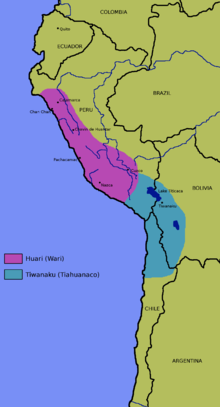
Throughout their imperial reign, the Tiwanaku shared domination of the Middle Horizon with the Wari. Their culture rose and fell
 snuff tablet ("rapero")
Lombards Museumaround the same time and was centered 500 miles north in the southern highlands of Peru. The relationship between the two empires is unknown either being cooperative or antagonistic. Definite interaction between the two is proved by their shared iconography in art. Significant elements of both of these styles (the split eye, trophy heads, and staff-bearing profile figures, for example) seem to have been derived from that of the earlier Pukara culture in the northern Titicaca Basin. The Tiwanaku created a powerful ideology, using previous Andean icons that spread throughout their sphere of influence using extensive trade routes and shamanistic art. Tiwanaku art consisted of legible, outlined figures depicted in curvilinear style with a naturalistic manner, while Wari art used the same symbols in a more abstract, rectilinear style with a militaristic manner.[25]
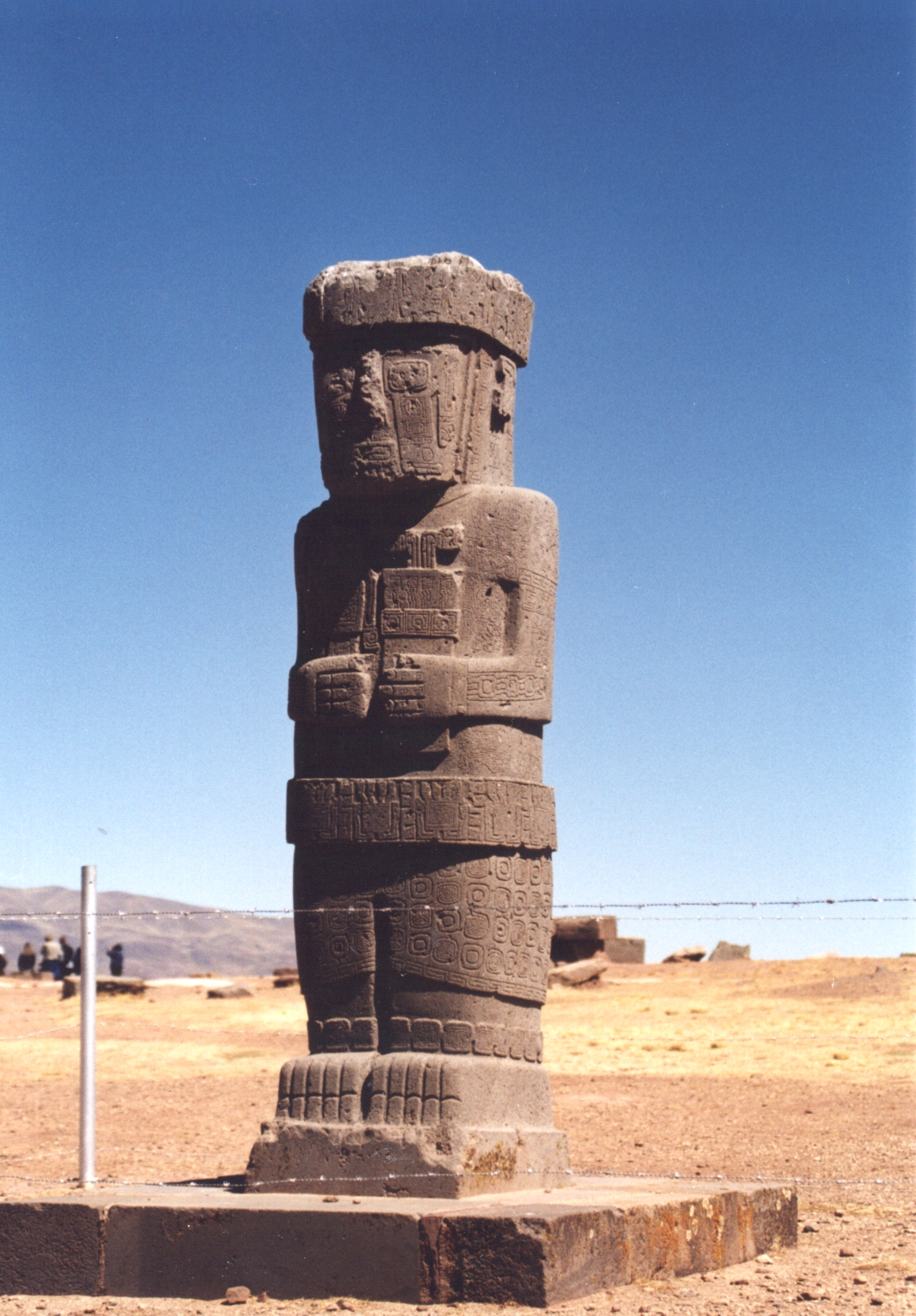
Tiwanaku sculpture is comprised typically of blocky column-like figures with huge, flat square eyes, and detailed with shallow relief carving. They are often holding ritual objects like the Ponce Stela or the Bennett Monolith. Some have been found holding severed heads such as the figure on the Akapana, possibly a puma-shaman. These images suggest ritual human beheading, which correlate with the discovery of headless skeletons found under the Akapana.
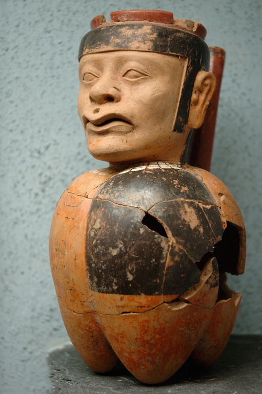
Ceramics and textiles were also present in their art, composed of bright colors and stepped patterns. An important ceramic artifact is the kero, a drinking cup, that was ritually smashed after ceremonies and placed in burials. However, as the empire expanded, ceramics changed in the society. The earliest ceramics were "coarsely polished, deeply incised brownware and a burnished polychrome incised ware". Later the Qeya style became popular during the Tiwanaku III phase "Typified by vessels of a soft, light brown ceramic paste". These ceramics included libation bowls and bulbous bottom vases.[26]
Examples of textiles are tapestries and tunics. The objects typically depicted herders, effigies, trophy heads, sacrificial victims, and felines. The key to spreading religion and influence from the main site to the satellite centers was through small portable objects that held ritual religious meaning. They were created in wood, engraved bone, and cloth and depicted puma and jaguar effigies, incense burners, carved wooden hallucinogenic snuff tablets, and human portrait vessels. Like the Moche, Tiwanaku portraits had individual characteristics in them.[27]
Religion
As there exists no local written language yet deciphered (khipus remain poorly understood), what is known of their religious beliefs are based on archaeological interpretation and some myths, which may have been passed down to the Incas and the Spanish. They seem to have worshipped many gods, perhaps centered around agriculture. One of the most important gods was Viracocha[citation needed], the god of action, shaper of many worlds, and destroyer of many worlds. He created people, with two servants, on a great piece of rock. Then he drew sections on the rock and sent his servants to name the tribes in those areas. In Tiwanaku he created the people out of rock and brought life to them through the earth. The Tiwanaku believed that Viracocha created giants to move the massive stones that comprise much of their archaeology, but then grew unhappy with the giants and created a flood to destroy them[citation needed].
Viracocha is carved into the most famous gateway[citation needed], the Gateway of the Sun, to overlook his people and lands. The Gateway of the Sun is a monolithic structure of regular, non-monumental size. Its dimensions suggest that other regularly sized buildings existed at the site. It was found at Kalasasaya, but due to the similarity of other gateways found at Pumapunku it was probably originally part of a series of doorways there.[1] It is recognized for its singular, great frieze which is thought to be some main deity figure surrounded by either calendar signs or natural forces for agricultural worship. Along with Viracocha, another statue is in the Gateway of the Sun. This statue, many believe, is associated with the weather: "a celestial high god that personified various elements of natural forces intimately associated the productive potential of altiplano ecology: the sun, wind, rain, hail - in brief, a personification of atmospherics that most directly affect agricultural production in either a positive or negative manner",[1] This statue is more complicated than Viracocha in that it has twelve faces covered by a solar mask and at the base thirty running or kneeling figures.[1] Some scientists believe that this statue is a representation of the calendar with twelve months and thirty days in each month.[1]
Other evidence, however, points to a system of ancestor worship at Tiwanaku. The preservation, use, and reconfiguration of mummy bundles and skeletal remains, like the later Inca, may suggest that this is the case.[1] Later cultures within the area made use of large "above ground burial chambers for the social elite ... known as "chullpas".[1] Similar, though smaller, structures were found within the site of Tiwanaku.[1] Kolata suggests that, like the later Inka, the inhabitants of Tiwanaku may have practiced similar rituals and rites in relation to the dead. The Akapana East Building has evidence of ancestor burial. In comparison to the brutal treatment of the dead on top of the Akapana, the human remains at Akapana East seem to be much less for show and more so for proper burial. The skeletons show many cut marks that were most likely made by defleshing after death. Then these individuals were bundled up and buried rather than left out in the open.[11]
Archaeology
 Ponce stela in the sunken courtyard of the Tiwanaku's Kalasasaya temple
Much of the architecture of the site is in a poor state of preservation, having been subjected to looting and amateur excavations attempting to locate valuables since shortly after Tiwanaku's fall. This destruction continued during the Spanish conquest and colonial period, and during 19th century and the early 20th century, and has included quarrying stone for building and railroad construction and target practice by military personnel.
Another issue for archaeologists is the lack of standing buildings at the modern site. Only public, non-domestic foundations remain, with poorly reconstructed walls. The ashlar blocks used in many of these structures were mass-produced in similar styles so that they could possibly be used for multiple purposes. Throughout the period of the site certain buildings changed purposes causing a mix of artifacts that are found today.[24]
 "Gateway of the Sun", Tiwanaku, drawn by Ephraim Squier in 1877. The scale is exaggerated in this drawing.
 Walls around the temple Kalasasaya
Detailed study of Tiwanaku began on a small scale in the mid-nineteenth century. In the 1860s, Ephraim George Squier visited the ruins and later published maps and sketches completed during his visit. German geologist Alphons Stübel spent nine days in Tiwanaku in 1876, creating a map of the site based on careful measurements. He also made sketches and created paper impressions of carvings and other architectural features. A book containing major photographic documentation was published in 1892 by engineer B. von Grumbkow. With commentary by archaeologist Max Uhle, this was the first in-depth scientific account of the ruins.
In the 1960s, an attempt was made at restoring the site, but by very uninformed parties.[citation needed] The walls pictured to the right, of the Kalasasaya, are almost all reconstruction. The original stones making up the Kalasasaya would have resembled a more "Stonehenge" like style, spaced evenly apart and standing straight up. Unfortunately, the parties that made the reconstructions decided to make the Kalasasaya be enclosed by a wall that they themselves built. Ironically enough, the reconstruction itself is actually much poorer quality stoneworking than the people of Tiwanaku were capable of.[citation needed] It should also be noted that the Gateway of the Sun, that now stands in the Kalasasaya, is not in its original location, having been moved sometime earlier from its original location.[1]
Modern, academically sound archaeological excavations were performed from 1978 through the 1990s by University of Chicago anthropologist Alan Kolata and his Bolivian counterpart, Oswaldo Rivera. Among their contributions are the rediscovery of the suka kollus, accurate dating of the civilization's growth and influence, and evidence for a drought-based collapse of the Tiwanaku civilization.
Archaeologists like Paul Goldstein argue that the Tiwanaku empire ranged outside of the altiplano area and into the Moquegua Valley in Peru. Excavations at Omo settlements show signs of similar architecture characteristic of Tiwanaku such as a temple and terraced mound.[20] Evidence of similar types of cranial deformation in burials between the Omo site and the main site of Tiwanaku is also being used for this argument.[28]
Today Tiwanaku is a UNESCO world heritage site, and is administered by the Bolivian government.
 Robotic exploration of a newly discovered tunnel in the Akapana pyramid, June 13, 2006
Recently, the Department of Archaeology of Bolivia (DINAR, directed by Javier Escalante) has been conducting excavations on the Akapana pyramid. The Proyecto Arqueologico Pumapunku-Akapana (PAPA, or Pumapunku-Akapana Archaeological Project) run by the University of Pennsylvania, has been excavating in the area surrounding the pyramid for the past few years, and also conducting Ground Penetrating Radar surveys of the area.
In former years, an archaeological field school offered through Harvard's Summer School Program, conducted in the residential area outside the monumental core, has provoked controversy amongst local archaeologists.[29] The program was directed by Dr. Gary Urton,[30] Harvard, expert in quipu, and Dr. Alexei Vranich of the University of Pennsylvania. The controversy had to do with the fact that permission to excavate Tiwanaku, being such an important site, is only provided to certified professional archaeologists and rarely to independent Bolivian scholars who scarcely can present proof of funding to carry on archaeological research. On that occasion permission was given to Harvard's Summer School to allow a team mostly composed of untrained students to dig the site. The controversy, charged with nationalistic and political undertones that characterized the archaeology of Tiwanaku [31] faded rapidly without any response from the directors. However, the project did not continue in subsequent years.
Restoration work
In 2009 state-sponsored restoration work on the Akapana pyramid was halted due to a complaint from UNESCO. The restoration had consisted in plastering the pyramid with adobe, despite it being unclear whether the result would bring the pyramid back to its original state.[1][2]
Lukurmata
Lukurmata was an important secondary site near Lake Titicaca in Bolivia. First established nearly two thousand years ago, it grew to be a major ceremonial center in the Tiwanaku state, a polity that dominated the south-central Andes from 400 to 1200. After the Tiwanaku state collapsed, Lukurmata rapidly declined, becoming once again a small village. The site also shows evidence of extensive occupation that antedates the Tiwanakan civilization.
See also
- List of megalithic sites
- List of archaeoastronomical sites sorted by country
- Wari
References
- ^ a b c d e f g h i j k l m n o p q r Kolata, Alan L. (December 15, 1993). The Tiwanaku: Portrait of an Andean Civilization. Wiley-Blackwell. ISBN 978-1557861832. http://www.amazon.com/dp/1557861838. Retrieved 9 August 2009.
- ^ Kelley, David H.; Milone, Eugene F. (November 19, 2004). Exploring Ancient Skies: An Encyclopedic Survey of Archaeoastronomy. Springer. ISBN 978-0387953106. http://www.amazon.com/dp/0387953108. Retrieved 9 August 2009.
- ^ Hughes, Holly (October 20, 2008). Frommers 500 Places to See Before They Disappear (500 Places). Frommers. pp. 266. ISBN 978-0-470-18986-3. http://www.frommers.com/store/047018986X.html. Retrieved 9 August 2009.
- ^ "Profile: Fabricio R. Santos - The Genographic project". Genographic Project. National Geographic. https://genographic.nationalgeographic.com/genographic/pi/santos_notes.html. Retrieved 2009-08-09.
- ^ Fagan, Brian M. The Seventy Great Mysteries of the Ancient World: Unlocking the Secrets of Past Civilizations. New York: Thames & Hudson, 2001.
- ^ Bruhns, K., 1994, Ancient South America. Cambridge University Press, 424 p.
- ^ a b Kolata, Alan L. 'The Agricultural Foundations of the Tiwanaku State: A View from the Heartland'. American Antiquity 51, 1986: 748-762
- ^ a b Kolata, Alan L. Valley of the Spirits: A Journey into the Lost Realm of the Aymara. John Wiley and Sons, Hoboken, 1996.
- ^ Bahn, Paul G. Lost Cities. New York: Welcome Rain, 1999.
- ^ a b McAndrews, Timothy L. et al. 'Regional Settlement Patterns in the Tiwanaku Valley of Bolivia'. Journal of Field Archaeology 24 (1997): 67-83.
- ^ a b Blom, Deborah E. and John W. Janusek. 'Making Place: Humans as Dedications in Tiwanaku'. World Archaeology (2004): 123-141.
- ^ Isbell, William H. 'Wari and Tiwanaku: International Identities in the Central Andean Middle Horizon'. 731-751.
- ^ Stanford News Service, "Lake Titicaca study sheds new light on global climate change" January 25, 2001.
- ^ Baker PA, PA; Dunbar RB, et.al. (2001-01-26). "The history of South American tropical precipitation for the past 25,000 years.". Science 291 (5504): 640–3. doi:10.1126/science.291.5504.640. PMID 11158674.
- ^ Lechtman, Heather N., MacFarlane, and Andrew W., 2005, "La metalurgia del bronce en los Andes Sur Centrales: Tiwanaku y San Pedro de Atacama". Estudios Atacameños, vol. 30, pp. 7-27.
- ^ a b c d Isbell, W. H., 2004, Palaces and Politics in the Andean Middle Horizon. in S. T. Evans and J. Pillsbury, eds., pp. 191-246. Palaces of the Ancient New World. Dumbarton Oaks Research Library and Collection Washington, D.C.
- ^ a b c d e f Ponce Sanginés, C. and G. M. Terrazas, 1970, Acerca De La Procedencia Del Material Lítico De Los Monumentos De Tiwanaku. Publication no. 21. Academia Nacional de Ciencias de Bolivia
- ^ Harmon, P., 2002, Experimental Archaeology, Interactive Dig - Archaeology Magazine's Online Excavations web page, Archaeology magazine.
- ^ Vranich, A., 1999, Interpreting the Meaning of Ritual Spaces: The Temple Complex of Pumapunku, Tiwanaku, Bolivia. Doctoral Dissertation, The University of Pennsylvania.
- ^ a b Goldstein, Paul (1993). Tiwanaku Temples and State Expansion: A Tiwanaku Sunken-Court Temple in Moquegua, Peru.
- ^ Browman, D. L., 1981, "New light on Andean Tiwanaku". New Scientist. vol. 69, no. 4, pp. 408-419.
- ^ Coe, Michael, Dean Snow, and Elizabeth Benson, 1986 Atlas of Ancient America p. 190
- ^ Silverman, Helaine Andean Archaeology Volume 2. Malden, Massachusetts: Blackwell Publishing, 2004
- ^ a b Protzen, J.-P., and S. E. Nair, 2000, "On Reconstructing Tiwanaku Architecture": The Journal of the Society of Architectural Historians. vol. 59, no., 3, pp. 358-371.
- ^ Stone-Miller, Rebecca (1995 and 2002). Art of the Andes: from Chavin to Inca.
- ^ Bray, Tamara L. The Archaeology and Politics of Food and Feasting in Early States and Empires. New York: Kluwer Academic/Plenum Publishers, 2003
- ^ Rodman, Amy Oakland (1992). Textiles and Ethnicity: Tiwanaku in San Pedro de Atacama.
- ^ Hoshower, Lisa M. (1995). Artificial Cranial Deformation at the Omo M10 Site: A Tiwanaku Complex from the Moquegua Valley, Peru.
- ^ Lémuz, C., 2007, Buenos Negocios, ¿Buena Arqueologia? Crítica Arqueológica Boliviana web site.
- ^ anonymous, 2005, Harvard Summer Program in Tiwanaku, Bolivia. Harvard Summer School Archives, Harvard University.
- ^ Kojan, David and Dante Angelo "Dominant narratives, social violence and the practice of Bolivian archaeology". Journal of Social Archaeology 5(3):383-408.
- Stone-Miller, Rebecca, Art of the Andes: from Chavin to Inca, Thames and Hudson Ltd., London, c. 1995 and 2002
- Bruhns, Karen Olsen, Ancient South America, Cambridge University Press, Cambridge, UK, c. 1994
- Goldstein, Paul, "Tiwanaku Temples and State Expansion: A Tiwanaku Sunken-Court Temple in Moduegua, Peru", Latin American Antiquity, Vol. 4, No. 1 (March 1993), pp. 22–47, Published by: Society for American Archaeology
- Kolata, Alan L., "The Technology and Organization of Agricultural Production in the Tiwanaku State", Latin American Antiquity, Vol. 2, No. 2 (June 1991), pp. 99–125, Published by: Society for American Archaeology
- Protzen, Jean-Pierre and Stella E. Nair, "On Reconstructing Tiwanaku Architecture", The Journal of the Society of Architectural Historians, Vol. 59, No., 3 (September 2000), pp. 358–371, Published by: Society of Architectural Historians
- Hoshower, Lisa M., Jane E. Buikstra, Paul S. Goldstein, and Ann D. Webster, "Artificial Cranial Deformation at the Omo M10 Site: A Tiwanaku Complex from the Moquegua Valley, Peru", Latin American Antiquity, Vol. 6, No. 2 (June, 1995) pp. 145–164, Published by: Society for American Archaeology
- Kolata, Alan L., "The Agricultural Foundations of the Tiwanaku State: A View from the Heartland", American Antiquity, Vol. 51, No. 4 (October 1986), pp. 748–762, Published by: Society for American Archaeology.
- Bermann, Marc Lukurmata Princeton University Press (1994) ISBN 978-0691033594
- Reinhard, Johan, "Chavin and Tiahuanaco: A New Look at Two Andean Ceremonial Centers." National Geographic Research 1(3): 395-422, 1985.
- Reinhard, Johan, "Tiahuanaco, Sacred Center of the Andes." An Insider's Guide to Bolivia. Peter McFarren (ed.). pp. 151–181. La Paz, 1990.
- Reinhard, Johan, "Tiwanaku: Ensayo sobre su cosmovisión." Revista Pumapunku 2: 8-66, 1992.
External links
- Map of Ingavi Province
- UNESCO World Heritage Site
- Interactive dig (Archaeology Magazine, Archaeological Institute of America)
- Research done at the University of Pennsylvania
- Tiahuanaco on emuseum.mnsu.edu
- Tiwanaku society by tiwanakuarcheo.net
- Daily Life at Tiwanaku
- Tiwanaku (Tiahuanaco) Site Bibliography
World Heritage Sites in Bolivia Jesuit Missions of the Chiquitos · Fuerte de Samaipata · Noel Kempff Mercado National Park · City of Potosí · Historic City of Sucre · Tiwanaku: Spiritual and Political Centre of the Tiwanaku Culture
 Categories:
- World Heritage Sites in Bolivia
- 1st-millennium BC establishments
- Archaeological sites in Bolivia
- Andean civilizations
- History of Bolivia
- Archaeoastronomy
- Former populated places in Bolivia
- La Paz Department, Bolivia


Wikimedia Foundation. 2010.