- North Okkalapa Township
-
North Okkalapa Township
မြောက်ဥက္ကလာပ မြို့နယ်— Township of Yangon — North Okkalapa Township 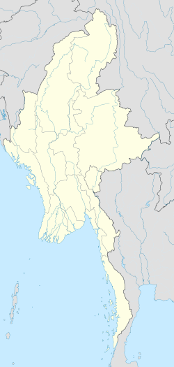
 North Okkalapa Township
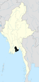
Coordinates: 16°49′0″N 96°6′0″E / 16.816667°N 96.1°ECoordinates: 16°49′0″N 96°6′0″E / 16.816667°N 96.1°E Country Myanmar Division Yangon City Yangon Township North Okkalapa Settled 1959[1] Area - Total 28.3 km2 (10.91 sq mi) Population (2000) - Total 243,000 Time zone MST (UTC6:30) Postal codes 11031, 11032 Area code(s) 1 (mobile: 80, 99) YCDC[2] North Okkalapa Township (Burmese: မြောက်ဥက္ကလာပ မြို့နယ်, pronounced [mjauʔ ʔouʔkəlàpa̰ mjo̰nɛ̀]) is located in the eastern part of Yangon. The township comprises 19 wards, and shares borders with Hlegu township and Mingaladon township in the north, North Dagon township in the east, Mingaladon township and Mayangon township in the west, and Kamayut township, and Mayangon township and South Okkalapa township in the south.[2] North Okkalapa was one of the satellite towns established in 1959.[1] Today, it is a firmly established part of the city, albeit with nominal access to the city's electricity grid and sewer system. Like most areas in the city, especially in working class neighborhoods like North Okkalapa, night-time electricity is available once every two or three days.
Contents
Education
The township has 30 primary schools, seven middle schools and five high schools.[2] It is also home to one of the most selective universities in the nation: the University of Medicine 2, Yangon, and the University of Pharmacy, Yangon.
Health
The North Okkalapa General Hospital, an affiliated teaching hospital of the University of Medicine 2, is the major hospital for the township and vicinity.
Landmarks
The following is a list of landmarks protected by the city in North Okkalapa township.[3]
Structure Type Address Notes Meilamu Pagoda Pagoda Thudhamma Road References
- ^ a b Kyaw Kyaw (2006). Frauke Krass, Hartmut Gaese, Mi Mi Kyi. ed. Megacity yangon: transformation processes and modern developments. Berlin: Lit Verlag. pp. 333–334. ISBN 3-8258-0042-3.
- ^ a b c "North Okkalapa Township". Yangon City Development Committee. http://www.yangoncity.com.mm/maps/townships_pro.asp?tname=north%20okkalapa. Retrieved 2009-03-15.
- ^ Special Reports: Heritage List. The Myanmar Times. 2001-10-29. http://www.myanmar.gov.mm/myanmartimes/no87/New/14.htm.
Districts/Townships of Yangon Western District
(Downtown)Ahlon Township · Bahan Township · Dagon Township · Kyauktada Township · Kyimyindaing Township · Lanmadaw Township · Latha Township · Pabedan Township · Sanchaung Township · Seikkan Township ·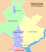
Eastern District Botataung Township · Dagon Seikkan Township · East Dagon Township · North Dagon Township · North Okkalapa Township · Pazundaung Township · South Dagon Township · South Okkalapa Township · Thingangyun TownshipNorthern District Hlaing Township · Hlaingthaya Township · Insein Township · Kamayut Township · Mayangon Township · Mingaladon Township · Shwepyitha Township · Yankin TownshipSouthern District Yangon Region Capital: Yangon Western District
(Downtown)Ahlon Township · Bahan Township · Dagon Township · Kyauktada Township · Kyimyindaing Township · Lanmadaw Township · Latha Township · Pabedan Township · Sanchaung Township · Seikkan Township
Eastern District Botataung Township · Dagon Seikkan Township · East Dagon Township · North Dagon Township · North Okkalapa Township · Pazundaung Township · South Dagon Township · South Okkalapa Township · Thingangyun TownshipNorthern District Hlaing Township · Hlaingthaya Township · Insein Township · Kamayut Township · Mayangon Township · Mingaladon Township · Shwepyitha Township · Yankin TownshipSouthern District Townships outside Yangon City Coco Island Township · Hlegu Township · Hmawbi Township · Htantabin Township · Kawhmu Township · Kayan Township · Kungyangon Township · Kyauktan Township · Taikkyi Township · Thanlyin Township · Thongwa Township · Twante TownshipMain cities and towns Administrative divisions of Burma (Myanmar) States 
Regions Self-Administered Zones Self-Administered Divisions WaUnion Territories Categories:- Townships of Yangon


Wikimedia Foundation. 2010.