- Narberth (SEPTA station)
-
Narberth Station
SEPTA regional rail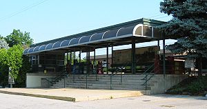
Narberth StationStation statistics Address 129 North Elmwood Avenue
Narberth, PA 19072Coordinates 40°00′17″N 75°15′41″W / 40.0047°N 75.2615°WCoordinates: 40°00′17″N 75°15′41″W / 40.0047°N 75.2615°W Lines Paoli/Thorndale LineConnections SEPTA City Bus: 44 Platforms 2 side platforms Tracks 4 Parking 110 spaces Other information Rebuilt 1980 Electrified 1915 Owned by SEPTA Fare zone 2 Services Preceding station SEPTA Following station toward ThorndalePaoli/Thorndale Line toward Temple UniversityNarberth Station is a commuter rail station located in the western suburbs of Philadelphia at Haverford and Narberth Avenues in Narberth, Pennsylvania.[1] It is served by most Paoli/Thorndale Line trains with the exception of several express runs.
The station was rebuilt around 1980 in a minimalist style common to that era, replacing a dilapidated wooden structure, under an agreement between SEPTA and the Narberth Borough Council, championed by Narberth Councilman Bharat Bhargava. The Ivy Ridge Station was also built in the same style.
The ticket office at this station is open weekdays 6:15 a.m. to 1:35 p.m. excluding holidays. There are 110 parking spaces at the station.
This station is in fare zone 2 and is 6.8 track miles from Suburban Station. In 2003, the average total weekday boardings at this station was 617.
References
External links
 Media related to Narberth (SEPTA station) at Wikimedia Commons
- SEPTA - Narberth Station
- An interactive aerial perspective at Visual Earth
- Page with historical pictures of station
- Station from Google Maps Street View
Categories:- SEPTA Regional Rail stations
- Stations along Pennsylvania Railroad lines
- Pennsylvania Main Line
- Transportation in Montgomery County, Pennsylvania
- Pennsylvania railway station stubs

Wikimedia Foundation. 2010.