- Pedro Domingo Murillo Province
-
Pedro Domingo Murillo — Province — Valle de la Luna ("Moon Valley") Location of Pedro Domingo Murillo Province within Bolivia
 Provinces of the La Paz Department
Coordinates: 16°30′0″S 68°0′0″W / 16.5°S 68°W Country  Bolivia
Department La Paz Department Foundation October 17, 1912 Capital Palca Area – Total 1,816.6 sq mi (4,705 km2) Population (2001) – Total 1,484,328 – Density 817.1/sq mi (315.5/km2) – Ethnicities Aymara Pedro Domingo Murillo is a province in the Bolivian department of La Paz. It contains the Bolivian administrative capital, La Paz, as well as the major city of El Alto.
Contents
Subdivision
The province is divided into five municipalities which are further subdivided into cantons.
Section Municipality Seat Capital municipality La Paz Municipality La Paz 1st Palca Municipality Palca 2nd Mecapaca Municipality Mecapaca 3rd Achocalla Municipality Achocalla 4th El Alto Municipality El Alto Places of interest
Some of the tourist attractions of the municipality are:[1]
- In La Paz Municipality:
- Huayna Potosí Snowcovered Mountain
- Cotapata National Park and Integrated Management Natural Area
- Abra de la Cumbre at a height of 4,650 m above sea level, the highest point on the route between La Paz and the Yungas
- Killi Killi viewpoint which presents a panoramic view of the city of La Paz
- Muela del Diablo ("Devil's Tooth"), a giant rock of about 150 m height that has the shape of a tooth
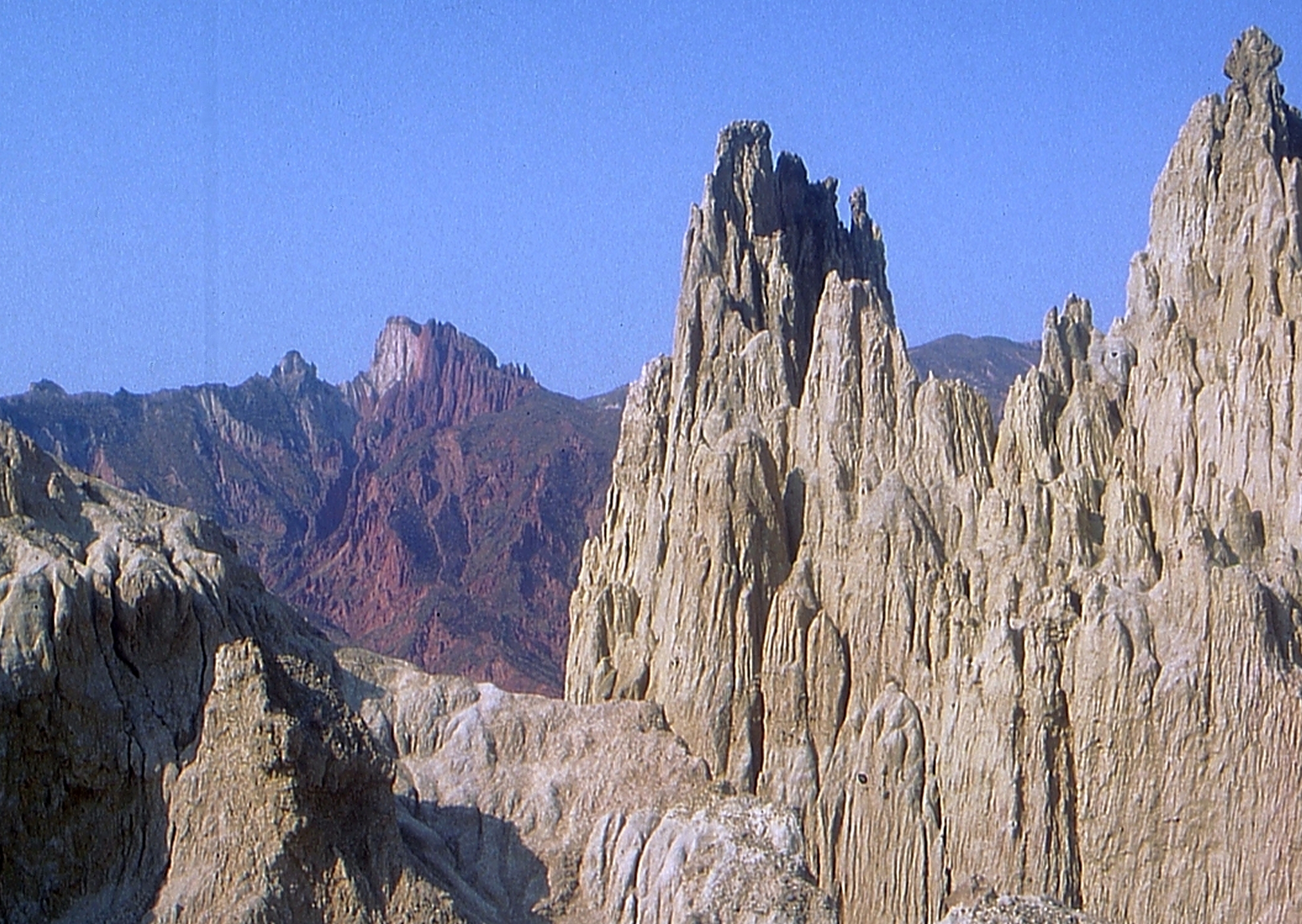
- Valle de la Luna ("Moon Valley"), south of La Paz city
- La Paz zoo "Vesty Pakos Sofra" with an area of 22.4 ha, the largest zoo in Bolivia, the second largest in South America and the highest in the world.
- Lake Inkachaka
- In Palca Municipality:
- Apacheta viewpoint in Palca Canton which offers a sight of the contrasting landscape and snowcapped Illimani
- Valle de los Ánimas ("Valley of the Souls") and its lake (Laguna de las Ánimas) in Palca Canton
- the town of Palca with houses of colonial times, Palca River, Chuaqueri gorge, also known as Palca gorge, and Takesi pre-Columbian trail in Palca Canton
- the communities of Quilihuaya and Pinaya in Quilihuaya Canton
- the community of Cohoni, its church dating from the 17th century and the chullpas of Ch'ullu Cahinbaya in Cohoni Canton
References
- ^ www.gobernacionlapaz.gob.bo Tourist guide by the government of the department
External links
 La Paz Department
  Capital: La Paz
Provinces Abel Iturralde • Aroma • Bautista Saavedra • Caranavi • Camacho • Franz Tamayo • Gualberto Villarroel • Ingavi • Inquisivi • José Manuel Pando • Larecaja • Loayza • Los Andes • Manco Kapac • Murillo • Muñecas • Nor Yungas • Omasuyos • Pacajes • Sud Yungas
Municipalities
(and seats)Achacachi (Achacachi) • Achocalla (Achocalla) • Alto Beni (Caserío Nueve) • Ancoraimes (Ancoraimes) • Apolo (Apolo) • Aucapata (Aucapata) • Ayata (Ayata) • Ayo Ayo (Ayo Ayo) • Batallas (Batallas) • Cairoma (Cairoma) • Cajuata (Cajuata) • Calacoto (Calacoto) • Calamarca (Calamarca) • Caquiaviri (Caquiaviri) • Caranavi (Caranavi) • Catacora (Catacora) • Chacarilla (Chacarilla) • Charaña (Charaña) • Chulumani (Chulumani) • Chuma (Chuma) • Collana (Collana) • Colquencha (Colquencha) • Colquiri (Colquiri) • Comanche (Comanche) • Combaya (Combaya) • Copacabana (Copacabana) • Coripata (Coripata) • Coro Coro (Coro Coro) • Coroico (Coroico) • Curva (Curva) • Desaguadero (Desaguadero) • El Alto (El Alto) • Escoma (Escoma) • General Juan José Pérez (Charazani) • Guanay (Guanay) • Guaqui (Guaqui) • Huarina (Huarina) • Ichoca (Ichoca) • Inquisivi (Inquisivi) • Irupana (Irupana) • Ixiamas (Ixiamas) • Jesús de Machaca (Jesús de Machaca) • La Asunta (La Asunta) • La Paz (La Paz) • Laja (Laja) • Licoma Pampa (Licoma) • Luribay (Luribay) • Malla (Malla) • Mapiri (Mapiri) • Mecapaca (Mecapaca) • Mocomoco (Mocomoco) • Nazacara de Pacajes (Nazacara) • Palca (Palca) • Palos Blancos (Palos Blancos) • Papel Pampa (Papel Pampa) • Patacamaya (Patacamaya) • Pelechuco (Pelechuco) • Pucarani (Pucarani) • Puerto Acosta (Puerto Acosta) • Puerto Carabuco (Puerto Carabuco) • Puerto Pérez (Puerto Perez) • Quiabaya (Quiabaya) • Quime (Quime) • San Andrés de Machaca (San Andrés de Machaca) • San Buenaventura (San Buenaventura) • San Pedro de Curahuara (San Pedro de Curahuara de Carangas) • San Pedro de Tiquina (San Pedro de Tiquina) • Santiago de Callapa (Callapa) • Santiago de Huata (Santiago de Huata) • Santiago de Machaca (Santiago de Machaca) • Sapahaqui (Sapahaqui) • Sica Sica (Sica Sica) • Sorata (Sorata) • Tacacoma (Tacacoma) • Taraco (Taraco) • Teoponte (Teoponte) • Tiwanaku (Tiwanaku) • Tipuani (Tipuani) • Tito Yupanqui (Tito Yupanqui) • Umala (Umala) • Umanata (Umanata) • Viacha (Viacha) • Waldo Ballivián (Tumarapi) • Yaco (Yaco) • Yanacachi (Yanacachi)
Mountains Alpamayo Chico • Condoriri • Anallajsi • Ancohuma • Chachacomani • Chacaltaya • Illampu • Illimani • Huayna Potosí • MururataProtected areas Apolobamba • Cotapata • Madidi • Pilón Lajas
Coordinates: 16°30′S 68°00′W / 16.5°S 68°W
Categories:- Provinces of Bolivia
- La Paz Department, Bolivia
- La Paz Department, Bolivia geography stubs
- In La Paz Municipality:


Wikimedia Foundation. 2010.