- Wilmslow Road
-
Coordinates: 53°25′44″N 2°13′37″W / 53.429°N 2.227°W
 Looking northwards on Oxford Road, Manchester
Wilmslow Road is a major thoroughfare in Manchester, England, running from Parrs Wood north into Manchester City Centre. Its name changes to Oxford Road at Whitworth Park, north of Rusholme, and changes again to Oxford Street, when it reaches the city centre.
The road runs through the centres of Didsbury, Withington, Fallowfield and Rusholme. It is a popular bus corridor which crosses the University of Manchester campus and the All Saints campus of the Manchester Metropolitan University. A number of hospitals are also to be found near the route.
Contents
History
 This milestone in Withington was placed by the Manchester and Wilmslow Turnpike Trust. It stands opposite a public house named The Turnpike.
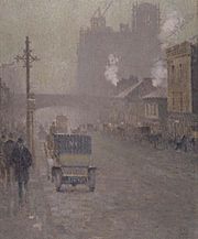 A 1910 oil painting of a foggy Oxford Road by Adolphe Valette. Construction of the Refuge Assurance Building can be seen in the background and the bridge remains the same.
 Oxford Road, a century later in 2010.See also: Turnpike trusts in Greater Manchester
Wilmslow Road, Oxford Road and Oxford Street are part of an 18th-century route from Manchester to Oxford, which can be traced on modern maps by locating roads which are called (or used to be called) the A34. New designations for this old route, including A3400 and A44, were assigned when motorways and bypasses took the A34 away from its original route. The route goes via Cheadle, Wilmslow, Congleton, Newcastle-under-Lyme, Stafford, Birmingham, Stratford-upon-Avon, and Woodstock.
In 1753 the Manchester and Wilmslow Turnpike Trust was created by Act of Parliament, with powers to build, maintain, and improve the most northerly stretch of the Manchester to Oxford route, funded by the collection of tolls.[1] In 1755 the Trust built the first stone bridge over the Mersey. This collapsed in 1756 and was rebuilt in 1758. The bridge was replaced in 1780 and again in 1861.
The improved transport links spurred the development of villages such as Rusholme and Withington along the route. These villages eventually merged and became part of the city of Manchester. Chorlton-on-Medlock, the district nearest the town centre, was developed as a residential suburb in 1793–94 by the three landowners. Most of the important streets were given impressive names, Oxford Street, Cambridge Street and Grosvenor Street being three of these. Over the next fifty years residential development spread southwards as far as High Street. The very few remaining dwellings of that period include Waterloo Place, 323, 325, 327 and 333 Oxford Road, and Grove House (316–324).[2]
In 1861 the Turnpike Trust was threatened with abolition but survived by offering to build Palatine Road from Withington to West Didsbury. All turnpike trusts in the United Kingdom were abolished in 1881. Until some time in the 1880s the parts which are now known as Oxford Road and Oxford Street were all Oxford Street (as far south as High Street, the old name of Hathersage Road). The present street and road with different series of house numbers were introduced so that Oxford Street ended at the old township border of the River Medlock. The Chorlton on Medlock section became Oxford Road and from Rusholme onwards was still Wilmslow Road.
Bus corridor
 Finglands' route 42Main article: Wilmslow Road bus corridor
Wilmslow Road is reputed to be the busiest bus corridor in Europe.[3] Several bus companies operate services along all or part of the corridor, competing for the large numbers of passengers who use the route. The main operators are Stagecoach Manchester (along with their low cost brand Magic Bus) and Finglands. Other buses along sections of route are provided by companies including Arriva, Bullocks Coaches and First Manchester. The number of competing companies has reduced in recent years, as since bus deregulation in 1986 it had been common for four or five different operators to run services along the length of the route at any one time.
The bus corridor is popular with passengers for its frequent bus services, relatively low fares, and services that run at almost any hour of the day. Other factors responsible for the high patronage include the high density of students and the notable public facilities that can be found along the route. Wilmslow Road is designated a Quality Bus Corridor by Greater Manchester Passenger Transport Executive.[4]
Landmarks
 The All Saints Building on the All Saints Campus of the Metropolitan University.
Sorted from north to south, although there is some overlap.
- The neoclassical Manchester Central Library stands on St Peter's Square at the beginning of Oxford Street
- The Odeon Cinema (derelict), originally the Paramount, 1931, in its later period converted to a multi-screen cinema. It once had a fine theatre organ.
- The Tootal, Broadhurst and Lee Building, Manchester (now Churchgate House)[5]
- The red brick and terracotta Refuge Assurance Building has a 217 foot tower and now houses the Palace Hotel.
- New Broadcasting House is the regional headquarters of the BBC in the North West of England.
- The All Saints Campus of Manchester Metropolitan University, the fourth largest university in the United Kingdom.
- MMUnion, the students Union for Manchester Metropolitan University
- The Royal Northern College of Music has a further 696 students.
- The University of Manchester is the largest "single-site" university in the United Kingdom[6] with over 40,000 students. It includes the neogothic Manchester Museum.
- Manchester Royal Infirmary is the chief site for Central Manchester and Manchester Children's University Hospitals NHS Trust.
- The Whitworth Art Gallery north of Whitworth Park.
- The Curry Mile is the stretch of Wilmslow Road in central Rusholme: it boasts at least 50 restaurants, take-aways and kebab houses specialising in the cuisines of South Asia and the Middle East.
- Fallowfield Campus is the main residential campus of the University of Manchester.
- Owens Park is a large hall of residence housing 1,056 students.
- Withington Public Library
- The Christie Hospital is one of the largest cancer treatment centres in Europe.
- The Didsbury Campus of the Manchester Metropolitan University.
- Parrs Wood High School is the fourth largest secondary school in the UK with 2,480 pupils.[7]
Boundaries and designations
Oxford Road and Oxford Street are a continuation of Wilmslow Road into the centre of Manchester. Oxford Street begins at St. Peter's Square. The name changes from Oxford Street to Oxford Road as the road crosses the River Medlock, placing Oxford Road railway station closer to Oxford Street. Oxford Road changes to Wilmslow Road at the junction with Hathersage Road. At the Parrs Wood end, Wilmslow Road crosses Cheadle Bridge over the River Mersey to become Manchester Road, Cheadle.
Oxford Street and a section of Oxford Road together form part of the A34. The B5117 comprises the rest of Oxford Road and part of Wilmslow Road. Wilmslow Road also contains part of the A6010, the whole of the B5093, part of the A5145 and the whole of the B5095. Despite these various names, the road can be considered as a continuous thoroughfare. A different Wilmslow Road exists in Cheadle, which is also part of the Manchester to Oxford route.
See also
- List of notable streets and roads in Manchester
References
- ^ "Cheadle Village Conservation Area Character Appraisal". March 2006. http://www.stockport.gov.uk/2013/2978/8803/9020/12299/cheadlevillageapp. Retrieved 5 April 2010.
- ^ Hartwell (2001)
- ^ O'Rourke, Aidan (2006-10-26). "Oxford Rd Manchester with Stagecoach bus". EyeOnManchester. http://www.eyeonmanchester.com/oxford-rd-manchester-buses/. Retrieved 2007-09-03.
- ^ "Greater Manchester QBC Map". GMPTE. http://www.gmpte.com/pdfmaps/qbc_map2.pdf. Retrieved 2008-10-08.
- ^ Behind it and not visible from the street is Lee House, the stub of what would have been the tallest building in Europe at 217 ft., a 17-storey warehouse (planned 1928; part completed 1931) (Simpson, Derek, ed. (1969) Manchester. London: Studio Vista; p. 33)
- ^ "Merged university 'largest in UK'". BBC News. 1 October 2004. http://news.bbc.co.uk/1/hi/england/manchester/3706094.stm.
- ^ "The school with two heads". South Manchester Reporter. http://www.southmanchesterreporter.co.uk/news/s/502327_the_school_with_two_heads. Retrieved 2007-11-14.
Categories:- Streets in Manchester


Wikimedia Foundation. 2010.