- Otelec
-
Otelec — Commune — 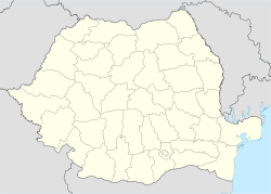
 Otelec
Coordinates: 45°37′N 20°51′E / 45.617°N 20.85°E Country  Romania
County Timiş County Time zone EET (UTC+2) - Summer (DST) EEST (UTC+3) Otelec (Hungarian: Ótelek) is a commune in Timiş County, Romania. Established in 1856, it was abolished in 1968 and absorbed into Uivar. It was recreated in 2008. The commune is composed of two villages, Iohanisfeld and Otelec.
Coordinates: 45°37′N 20°51′E / 45.617°N 20.85°E
References
Categories:- Communes in Timiş County
- Timiş County geography stubs

Wikimedia Foundation. 2010.