Orote Peninsula

Orote Peninsula
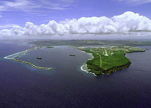
Aerial view of Apra Harbor, with the Orote Peninsula to the right.

The Orote Peninsula is a four kilometre-long peninsula jutting from the west coast of Guam. It forms the southern coast of Apra Harbor, and its westernmost tip, Point Udall, is also Guam's westernmost point. The south coast of Orote Peninsula meets the rest of the island at the long sweep of Agat Bay.

Orote Peninsula is the site of Naval Base Guam, and is also the location of the small settlement of Lockwood Terrace.

The peninsula was also featured in the epilogue of the hit TV Show Lost. A Dharma Initiative station in charge of pallet drops of food to a mysterious island, was based on the peninsula.

Coordinates: 13°26′N 144°38′E / 13.44°N 144.63°E / 13.44; 144.63


Wikimedia Foundation. 2010.

Игры ⚽ Поможем сделать НИР

Look at other dictionaries:

  • Orote Point — is the westernmost point on the mainland of Guam. It lies at the mouth of Apra Harbor, on the end of Orote Peninsula, opposite the Glass Breakwater of Cabras Island which forms the northern coast of the harbor.References*Bendure, G. Friary, N.… …   Wikipedia

  • Point Udall (Guam) — Point Udall (Orote Point) is the headland on the right in this view of Apra Harbor s mouth Point Udall (13°26′51.2″N …   Wikipedia

  • National Register of Historic Places listings in Guam — Map of Guam This is a list of the buildings, sites, districts, and objects listed on the National Register of Historic Places in Guam. There are currently 121 listed sites spread across 17 of the 19 villages of Guam. The villages of Agana Heights …   Wikipedia

  • Battle of Guam (1944) — Infobox Military Conflict partof=World War II, Pacific War conflict=Battle of Guam caption=Two U.S. officers plant the American flag on Guam eight minutes after U.S. Marines and Army assault troops landed date=July 21 – August 8 1944 place=Guam,… …   Wikipedia

  • Japanese occupation of Guam — Infobox Historical Event Event Name = Japanese Occupation of Guam Image Caption = AKA = Participants = Japanese Location = Guam Date = 11 December 1941 August 10 1944 Result = Ended August 10, 1944Japanese Occupation of Guam was the period in the …   Wikipedia

  • USS Pennsylvania (BB-38) — was the lead ship of her class of United States Navy super dreadnought battleships. She was the third Navy ship named for the state of Pennsylvania.She was laid down 27 October 1913, by the Newport News Shipbuilding and Dry Dock Company, Newport… …   Wikipedia

  • Cabras Island — is a long finger of low lying reef and land whichforms the northern shore of Apra Harbor, Guam. The island s length has been extended artificially by the Glass Breakwater, named for Captain Glass, who took Guam for the United States in 1898. A… …   Wikipedia

  • Santa Rita, Guam — Infobox Settlement settlement type = Village subdivision type = Country subdivision name = United States subdivision type1 = Territory subdivision name1 = Guam subdivision type2 = subdivision name2 = timezone=ChST utc offset=+10 unit… …   Wikipedia

  • Guam — This article is about the United States island territory of Guam. For GUAM, an eastern European international organization, see GUAM Organization for Democracy and Economic Development. Guam Guåhan …   Wikipedia

  • Apra Harbor — is a deep water port on the western side of Guam in the Mariana Islands. It serves both as a U.S. Navy station and a commercial port, which handles about 2 million tons of cargo a year .The harbour is formed by Orote Peninsula to the south, and… …   Wikipedia

Share the article and excerpts

Direct link
Do a right-click on the link above
and select “Copy Link”