- Kuku Nyungkal people
-
Kuku Nyungkal Aka: Kokonyungal (Tindale),
Gugu Njunggal (AIATSIS), Kuku-Nyungkul (SIL)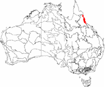
Wet Tropics BioRegionHierarchy Language Family: Pama–Nyungan Language Branch: Yalandyic Language Group: Kuku Yalanji Dialect: Kuku Nyungkal Estates: Kuna[1]
Ngulungkaban[1]
Muwan[1]
Jiraraku[1]
Wulumuban[1]
Ngarrimurril[1]
Nyambilnyambil[1]
Yulbu[1]
Yumal[1]
Kabu[1]Area (approx. 800 km²) BioRegion: Wet Tropics Location: Far North Queensland Coordinates: 15°40′S 145°15′E / 15.667°S 145.25°ECoordinates: 15°40′S 145°15′E / 15.667°S 145.25°E Mountains: Black Mountain
(aka Kalkajaka[2][3])
Mount Amos
(aka Muku Muku[4]
Mount FinniganRivers Annan River
(aka Yuku-Baja[3][5])
Upper Normanby River[6]Creeks Russell Creek
(aka Ngarrilmurril[3])
Banana CreekOther Geological: Shiptons Flat
(aka Kuna[5])
Kings Plain
(aka Dandi[5])
Cedar Bay
(aka Mangkalba[5])
Hope IslandsSettlements: Helenvale
(aka Bibikarrbaja[5]),
Rossville
(aka Ngulangaban[5])Notable Individuals Noel Pearson[7] Henrietta Marrie The Kuku Nyungkal people (or Annan River Tribe[8]) are a group of Aboriginal Australians who are the original custodians of the coastal mountain slopes, wet tropical forests, waters, and waterfalls of the Upper Annan River, south of Cooktown, Queensland
All Kuku Nyungkal people share in common social descent from ancestors who back to time immemorial have transmitted, from generation to generation, their Kuku Nyungkal dialect, knowledge, names (for people, places, and things), traditions, heritage, plus lore[6]
In 1995 Queensland's Aboriginal Land Tribunal, relying on Kuku Nyungkal genealogical material submitted to them, estimated the total population of Kuku Nyungkal people to be "at least 900" (not including those people who had married into Kuku Nyungkal families)[6]
Contents
Country
Norman Tindale's (1974) Catalogue of Australian Aboriginal tribes identifies Kokonyungal country as covering from "Annan River; south to Rossville; west to Annan-Normanby Divide"[8]
Kuku Nyungkal people, in their own country based Strategic Plan, describe the extent of their country as follows[9]:
Kuku Nyungkal Country lies in the northern part of the Wet Tropics World Heritage Area. The boundaries of our Country stretch from Annan River, Kings Plain, Rossville, Shiptons Flat and Mount Amos/Archer Point to Cedar Bay and includes Hope Islands
A locally informed and produced "Bama Way" map acknowledges Kuku Nynungkal country and advises it is bounded to the north by the lower Annan River (aka Yuku Baja), and to the south by Russell Creek (aka Ngarrilmurril')[3]
Lore
Kuku Nyungkal local lore for their country has been described to anthropologist Dr Christopher Anderson as follows[10]
The Upper Annan River area was divided into [between nine and twelve ] patrilineal clan estates. Each estate was based on a discrete part of the Annan drainage basin... These ... estates formed a linguistically and culturally distinctive bloc over which travel and access to resources were relatively free for any person associated with the estates
here was a tendency for all adult men to attempt to stay on their own patrilineal estates ... [and] the land-using groups consisted ... of people related in a variety of ways….based on a ‘core element’ consisting of a focal male, known as maja maja, his wives and children. The maja maja were identified with particular semi-permanent camps within their own patrilineal clan estate. These men would try to stay as much as possible at their own camps within their own estates, for it was there that their power was greatest
The maja maja were particular individuals of high achieved status and power ... who by virtue of their age, their knowledge of and supposed connections with the supernatural forces emanate in the ngujakura (law’ or ‘dreaming’)... were charged with the ‘minding’ and ‘looking after’ of their respective countries and the people associated with them. They ensured the health and well being in the human world and order in the natural world – particularly the steady supply of resources from the land .. by overseeing the maintenance of law’ by everyone. The breaking of social and cultural regulations was seen almost always to have ecological consequences, and moral knowledge and subsistence knowledge were seen as inextricably linked
With their perceived special relationship to the yirru or ‘nature-spirit’ which was said to live in the ground at certain sites ...the old men were able to ... sanction or punish ... breaches of the moral code
History
Prior to the 1880s, Kuku Nyungkal people had, since time immemorial, possessed, occupied, used and enjoyed their country in accordance with their lore[9] as follows:
Our Bama lore was strong in the past years ... The lore was made and enacted by Elders .. Everyone has responsibility for passing the lore down to the next generation and for carrying it out ... Some lagoons, swamps, springs and beaches are special story places with lores associated with them. Some are sickness places, some are healing places, some are special places of birds, or feeding areas for other animals. There are special places for hunting and gathering seasonal food such as crab, mussels, bird eggs and certain fish etc
In 1885 tin was discovered at Mount Amos, within Kuku Nyungkal country, following which Kuku Nyungkal people first experienced a small scale "invasion" by tin miners, then decades of sustained tin mining of their country[6][11]
Looking back, in retrospect, Kuku Nyungkal people living in the area, reflected on the tin mining era, leading anthropologist Dr Christopher Anderson to conclude[10]:
A major effect of tin mining was the disturbance if not outright destruction of ... sites of significance to Kuku Nyungkal people. Almost all important sites in this region are (or were) associated with waterholes and/or waterfalls.
Much of the illness and accidents which Europeans suffered in this area were attributed by Kuku Nyungkul to these actions. Violent thunderstorms or big winds, as well as the failure of certain food resources to appear properly or on time were also said to have stemmed from these actions.
The disturbances which tin-mining brought to these sites could possibly also have had some kind of spiritual or psychological ill-effect for Kuku-Nyungkal people. Because the sites were foci for power of which old mean were meant to have exclusive control, the flouting of site entry restrictions and site disturbance by Europeans ... had important effects
Over the decades that followed Queensland authorities felt it necessary to progressively encourage and often forcibly remove Kuku Nyungkal people from the tin mining areas and associated external settlement, into lands specially reserved for the purpose such as Ayton,[3] Hopevale, Yarrabah, and other reserves.[12]
During the 1950s Lutheran Church of Australia properly established an Aboriginal mission on the Bloomfield River, into which the remnant Kuku Nyungkal population still living on their country were moved.[9] The Lutheran Church described the situation as follows[13]:
The Bama [trans. people] are deeply hurt (the degree can hardly be described) that across the years they have been 'evicted' from their traditional lands by the encroachment of white settlers. From their traditional hunting grounds they were gradually herded into camps along or near the Bloomfield River. Finally they have been constricted within the confines of a 250 acre reserve at Wujal Wujal. The depth of their feelings was variously expressed: "We are like a crane standing on one leg (no room for two feet on the ground) on a little island" : "we are like animals in a wild cage"
Present
By 1995, one century after the initial "invasion" by tin miners, an Aboriginal Land Tribunal inquired into the extent to which Kuku Nyungkal traditions, beliefs, and people had been impacted by the colonization of their country. At that time Kuku Nyungkal representatives submitted, and the Tribunal agreed[6]:
Aboriginal culture in south eastern Cape York Peninsula has changed considerably since the arrival of the first European land visitor in 1872 ... Technological innovations and introductions have altered many aspects of Kuku-Nyungkul life and their economic and political system has also been affected by the social forces of a dominant way of life imposing itself on a previously independent people. Living away from country in a centralised community much of the time has also meant changes. The culture of the Kuku-Nyungkul people is not the same as it was one hundred years ago.
On 9 December 2007, the Kuku Nyungkal people were included within an overarching Federal Court native title determination in which their legal right to their own lands and waters was retrospectively acknowledged, and new exclusive rights to possess, occupy, use and enjoys some of their original lands along the Annan River was restored[14]
See also
- Kuku Nyungkal language
Notes
- ^ a b c d e f g h i j Anderson, Christopher (1983) "Aborigines and Tin Mining in North Queensland: A case study in the Anthropology of Contact History" The Australian Journal of Anthropology 13(6): 473-498
- ^ Environmental Protection Agency (Qld) "Black Mountain ((Kalkajaka) National Park - Features" Accessed 24 February 2009
- ^ a b c d e "Bama Way" map Accessed 13 March 2009
- ^ Anderson 1983: 475)
- ^ a b c d e f Hershberger, Henry & Hershberger Ruth (1986) "Kuku Yalanji Dictionary Summer Institute of Linguistics. Darwin" Accessed 16 March 2009
- ^ a b c d e Australian Indigenous Law Reporter (1996) Aboriginal Land Claim to Available Crown Land near Helenvale: Wunbuwarra - Banana Creek Accessed 14 March 2009
- ^ Aboriginal Land Tribunal (1995) "Aboriginal Land Claim to Available Crown Land near Helenvale: Wunbuwarra - Banana Creek" Report to the Hon. Minister for Lands, November 1995, Queensland Government.
- ^ a b Tindale, Norman (1974) "Kokobujundji (QLD)" in his Catalogue of Australian Aboriginal Tribes. South Australian Museum Accessed 13 March 2009
- ^ a b c Bana Yarraliji Bubu Incorporated (2008) Strategic Plan for Kuku Nyungkal Country. Cairns.
- ^ a b Anderson, Christopher (1983) Aborigines and Tin Mining in North Queensland: A Case Study in the Anthropology of Contact History" Mankind Vol. 13.No. 6.pp 473-498
- ^ "Collingwood Water Race (entry CHIMS3908)". Queensland Heritage Register. Queensland Environmental Protection Agency. http://www.epa.qld.gov.au/chims/placeDetail.html?siteId=3908. Retrieved 25 February 2009.
- ^ Anderson, C & Coastes, S (1989) "Like a Crane Standing on One Leg on a Little Island". Research Study No. 1. The Underlying Causes for the Deaths of Australian Aboriginal People in Government Detention. National Aboriginal and Islander Legal Services Secretariat.
- ^ Lutheran Church of Australia(Queensland) (1978) "Report of Visitation 11–29 June", quoted in Bana Yarraliji Bubu Incorporated (2008) Strategic Plan for Kuku Nyungkal Country. Cairns.
- ^ National Native title (2007) "Eastern Kuku Yalanji People's native title determination" Accessed 16 March 2009
References
- Anderson, Christopher (1983) "Aborigines and Tin Mining in North Queensland: A Case Study in the Anthropology of Contact History" Mankind. 13(6) pp 473–498
External links
- AusAnthrop Australian Aboriginal tribal database entry for Nyungal
- Gordon, Raymond G., Jr. (ed.), 2005. "Kuku Yalanji" entry in Ethnologue: Languages of the World, Fifteenth edition. Dallas, Tex.: SIL International. Online version
- Tindale, Norman (1974) "Kokobujundji (QLD)" in his Catalogue of Australian Aboriginal Tribes. South Australian Museum.
- Unitied Nations University's Media Studio's (2008) Walking on Country with Spirits video brief showing Kuku Nyunkal woman (Marilyn Wallace) telling of Kuku Nyunkal country
- Kuku Nyungkal Cultural Information Management System - webpage with some publicly available material
- Bana Yarralji Bubu Inc & University of Queensland video "Nyungkalwarra Bama Returning to Country
- Blog describing journey of Kuku Nyungkal cultural entrepreneurs seeking to restore Kuku Nyungkal lore and people to Kuku Nyungkal country
Categories:- Aboriginal tribes of Queensland
- Far North Queensland

Wikimedia Foundation. 2010.