- North West Slopes
-
North West Slopes
New South Wales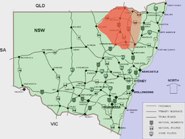
Approximate area of the North West SlopesLGA: - Moree Plains Shire
- Tamworth Regional Council
- Narrabri Shire
- Gunnedah Shire
Federal Division: Parkes The North West Slopes region of New South Wales, Australia refers generally to the area west of the Northern Tablelands, to the north of the Central West region and to the east of the Far West region. The region corresponds generally to the Australian Bureau of Meteorology's forecast area of North West Slopes and Plains. [1]
It is higher, hillier and wetter on its eastern edge than on its western edge. The North West Slopes are situated on various tributaries to the Darling River, which rise in the Great Dividing Range country to its east, such as the Barwon, Gwydir, and Namoi Rivers.
The North West Slopes includes the towns of Gunnedah, Warialda, Manilla, Boggabri, Mungindi, Narrabri, Moree, Quirindi, Wee Waa, the city of Tamworth and many villages.[2]
It has traditionally been a major wheat-growing area, but in recent decades irrigated crops, especially cotton, have become significant. The primary exports are cotton, coal, beef, lamb and pork, cereal and oilseed grains.
The North West region is traversed by the New England Highway, Newell Highway, the Kamilaroi Highway, Oxley Highway and the Gwydir Highway and by railways such as the Main Western railway line, linking Bourke to Sydney with connections to the port of Newcastle. The Main North railway line trains no longer continue to the Queensland border, but Werris Creek, Tamworth and Kootingal are still served by the Countrylink Xplorer service between Sydney and Armidale.
Mount Kaputar National Park, near Narrabri, is within the North West Slopes region.
This region is often included as part of the New England region. Sometimes the region is also known as the New England North West[3] or less commonly the Northern Inland Region[4] when it also includes the Northern Tablelands.
Local Government Areas (LGA) include Gunnedah Shire, Liverpool Plains Shire, Moree Plains Shire, Narrabri Shire, Gwydir Shire and Tamworth Regional Council.
See also
References
- ^ "Forecast areas". Bureau of Meteorology. http://www.bom.gov.au/weather/nsw/nsw-forecast-map.shtml. Retrieved 2006-11-06.
- ^ New South Wales Forecast Areas Map Retrieved on 2009-10-14
- ^ New England North West Retrieved 2009-9-27
- ^ Northern Inland Region Retrieved 2009-10-7
External links
Categories:

Wikimedia Foundation. 2010.