- Inner Circle railway line
-
Inner Circle railway line, Melbourne 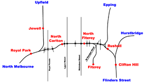
Line details Opened 1888 Closed 1981 Fate Parkland Connections Upfield and Epping lines Railways in Melbourne List of stations
Freight railways
Closed railways
Proposed railways Remains of Inner Circle Railway Line, crossing Brunswick Street North, in Fitzroy North, Victoria, Australia. Railway line is now part of a bike path.
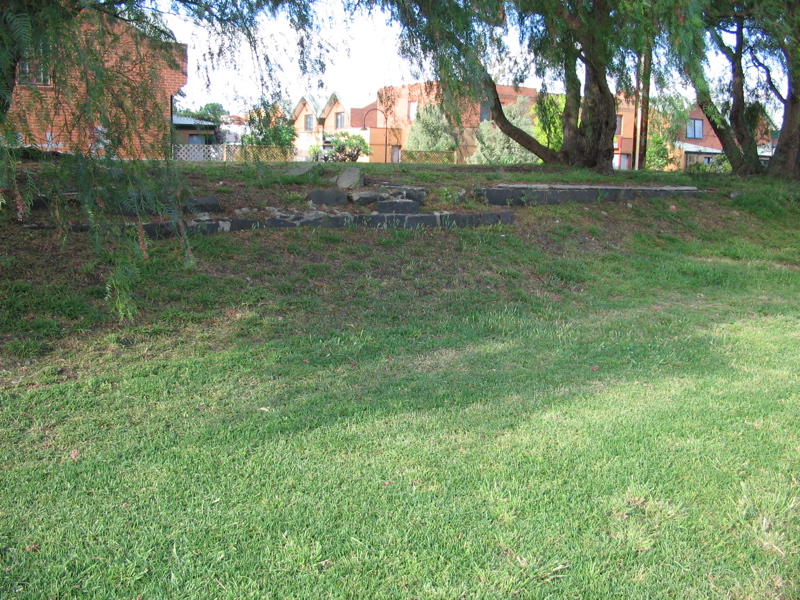
 Ruins of the former North Fitzroy railway station
 The North Fitzroy Electric Railway Substation, built in 1915 to supply power to the Inner Circle line
The Inner Circle was a steam era suburban railway line, (later electrified), in Melbourne, Australia. It covered the inner-northern suburbs of Parkville, Carlton North, Fitzroy North, and Fitzroy. At its closure, it ran from Royal Park station on the Upfield line (Melway map ref: 29 F11.) to the west, to a three-way intersection with Rushall and Merri stations on today's Epping line to the east. (Melway map ref: 30 D11.) There was also a branch line to Fitzroy that opened at the same time.
Contents
History
The Inner Circle was opened on 8 May 1888[1] with three stations: North Carlton station and North Fitzroy station on the main line, and Fitzroy station on a short branch line leading south after North Fitzroy station through the Edinburgh Gardens.
As the main line
When the Inner Circle line first opened it provided two services, both originating from Spencer Street Station at the western end of the central business district. Trains bound for Heidelberg station (now on the Hurstbridge line, but then a terminus), would run to North Fitzroy station, then continue on to Victoria Park station (then known as Collingwood, and now on the Hurstbridge and Epping lines) to the south. The locomotive would then have to change ends and the train return to Clifton Hill station, then diverge east on to Heidelberg.
In December 1889, with the opening of the Whittlesea line, trains would run from Flinders Street to Whittlesea via the Inner Circle. Another service followed this route, but terminated at Preston station.
Another service was provided from Spencer Street to Fitzroy station, on its branch line. This was relegated to a short shuttle service from North Fitzroy station in October 1889, and then finally closed in May 1892.
For a short period between March and May 1891, the Inner and Outer Circle routes formed the only route between the Eastern and Western halves of the Victorian Railways. Prior to this, the only link was via a street level tramway along the CBD edge between Flinders and Spencer Streets, which was generally only used at night. As the Viaduct between Spencer and Flinders Street stations was in its final stages of construction (December 1888 to May 1891), the two new lines allowed freight trains to bypass the construction site.
Replaced by direct line
In 1901 a new direct line was built from the central Flinders Street Station at the southern edge of the CBD though the inner eastern suburb of Abbotsford. This removed the need for the reversal manoeuvre for Heidelberg bound trains, and Preston suburban service also ran via the new line, while Whittlesea trains continued to use the Inner Circle, albeit only from Spencer Street.
With the loss of the main line services on the Inner Circle, a series of 'roundabout' services were experimented with from 1901. By 1906 a regular steam operated service was established from Princes Bridge to North Fitzroy station via Clifton Hill, and by 1919 this service was running every hour off peak.[2]
Electrification on the line between Royal Park and Clifton Hill stations was commissioned on 31 July 1921.[2] With electrification the services were extended to North Carlton running at 15 minute headways, but from 18 September 1921 they were changed to every 20 minutes.[2] Two trains on weekdays, and a larger number at weekends were extended to Royal Park station to serve patrons of the Melbourne Zoo.[2]
There was a possibility for revitalization in 1940, the Ashworth Improvement Plan recommended a subway tunnel with five stations be built under the Melbourne CBD from Flinders Street to the Inner Circle, with a proposed future subway from the first station to North Melbourne.
Traffic on the line was discouraged by the circuitous route, and competition with more direct trams to the city.[2] Off peak services were cut to every 30 minutes from 29 May 1944, but from 4 December 1944 20 minute headways were restored on Saturday and Sunday afternoons. The passenger service was finally cancelled on 3 July 1948 and North Carlton and North Fitzroy stations closed to passenger business.[2]
Freight only
From 1948 the Fitzroy line was used almost exclusively for freight trains. The overhead wiring on the line was dismantled in 1961, with only that needed for Epping trains and for shunting at the Royal Park end retained.[2] Significant changes occurred to the line in 1965, when the line was singled and both legs of the triangle at the eastern end of the line closed.[1] This left just the single line from Royal Park to Fitzroy remaining for goods services. The line was officially closed on 31 July 1981.[1]
In the same year a new loop service was introduced in the form of the underground City Loop, which directly encircles the CBD.[3]
Today
After the final closure, the rails were removed (except for some short sections at former level crossings which can still be seen today), and the reservation converted into a "rail-trail" walking path. Some signals and parts of level crossing gates also survive, with remaining overhead gantry sections still carrying railway electrical current between the Upfield and Epping railway lines.
Of the three stations, only North Carlton still stands, and was converted into a community centre.[4] North Fitzroy station is now a slight rise in the "rail trail" path east of Nicholson Street, which was realigned in 2002 to traverse the length of the former platform. Fitzroy station is presently a development site.
From Rushall station to Royal Park station the rail reserve has become a linear park which provides part of the Capital City Trail for cyclists, connecting the Merri Creek Trail to the Moonee Ponds Creek Trail in the network of shared use bicycle paths for Cycling in Melbourne.
Stations
Inner Circle railway line Legend

Epping line at Rushall 


Fitzroy - closed to passengers May 1892 and to goods August 1981 
North Fitzroy (Nicholson Street) - closed to passengers 1948 and to goods July 1981 North Carlton (Langridge Street, now Lang Street) - closed in 1948 except for some leaseholders. Closed totally November 1977 
Upfield line at Royal Park References
See also
External links
- City of Yarra: Inner Circle Railway Linear Park
- Victorian Railways signalling diagram: North Fitzroy to Merri in 1932
- Victorian Railways signalling diagram: Macaulay to North Fitzroy in 1913
- Victorian Railways signalling diagram: Macaulay to North Carlton in 1932
- 1920 Morgan's Street Directory Map: Inner circle station locations
Categories:- Closed Melbourne railway lines
- 5ft 3in gauge railways


Wikimedia Foundation. 2010.