Nordkinn Peninsula

Nordkinn Peninsula
Map of the peninsula

Nordkinn Peninsula (Norwegian: Nordkinnhalvøya/Nordkynhalvøya, Northern Sami: Čorgašnjárga) is a peninsula in Finnmark, in northern Norway. Settlement is mostly concentrated on the northern shores and at the base of the peninsula. The main towns are Mehamn, Gamvik and Kjøllefjord.[1] The Slettnes lighthouse near Gamvik is the northernmost lighthouse in mainland Europe.[2]

Geography

The highest point is Storvarden (486m) in the Sandfjellet massif. The northernmost point on the peninsula is the Kinnarodden cliff, being also the northernmost point of mainland Norway and Europe.

To the east the peninsula is bounded by the Tanafjord, which separates it from Varanger Peninsula. To the west it is bounded by the Laksefjord separating it from the uninhabited Sværholt Peninsula. In the north the waters of Laksefjord join with those of Porsanger Fjord, emptying into the Barents Sea.

Transport

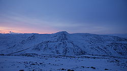
Icebound and windswept tundra of the Nordkinn Peninsula at midday during polar night.

Regional route 888 connects Gamvik, Mehamn, and Lebesby to the European route E6 at the base of the peninsula, and thence to Kirkenes in the east and Alta in the west. The Hurtigruten coastal ship stops in Mehamn and Kjøllefjord.[3]

Mehamn is also connected by air via Mehamn Airport, with services by Widerøe.[4]

References

Coordinates: 70°56′4″N 27°53′19″E / 70.93444°N 27.88861°E / 70.93444; 27.88861


Wikimedia Foundation. 2010.

Игры ⚽ Нужно решить контрольную?

Look at other dictionaries:

  • Península Escandinava — Saltar a navegación, búsqueda Imagen satelital tomada el 19 de febrero de 2003. La Península Escandinava es una península localizada en el noroeste de Europa, entre el …   Wikipedia Español

  • Cape Nordkinn — Kinnarodden Cape Nordkinn (Norwegian: Kinnarodden, also called Nordkyn) at …   Wikipedia

  • Mehamn —   Village   Mehamn in winter …   Wikipedia

  • List of peninsulas — A peninsula is a piece of land that is nearly surrounded by water but connected to mainland via an isthmus. A peninsula can also be a headland, cape, island promontory, bill, point, or spit. [ [http://www.britannica.com/ebi/article 9276348… …   Wikipedia

  • Geography of Norway — Continent Europe Region Northern Europe Area 385,199 km2 (148,726 sq mi) Borders Total land borders …   Wikipedia

  • Nordkapp — This article is about the municipality in Finnmark, Norway. For the North Cape (Norwegian: Nordkapp), see North Cape, Norway. Nordkapp kommune   Municipality   …   Wikipedia

  • North Cape, Norway — For other uses, see North Cape. Coordinates: 71°10′21″N 25°47′40″E / 71.1725°N 25.79444°E / 71.1725; 25.79444 …   Wikipedia

  • Northern Norway — Nord Norge   Region (landsdel)   A branch of …   Wikipedia

  • Polar night — Typical blue twilight experienced during the polar night in Longyearbyen, Svalbard located at 78 degrees north. The polar night occurs when the night lasts for more than 24 hours. This occurs only inside the polar circles. The opposite… …   Wikipedia

  • Mehamn Airport — Mehamn Lufthavn IATA: MEH – ICAO: ENMH …   Wikipedia

Share the article and excerpts

Direct link
Do a right-click on the link above
and select “Copy Link”