- 2004 Indian Ocean earthquake and tsunami
-

2004 Indian Ocean earthquake 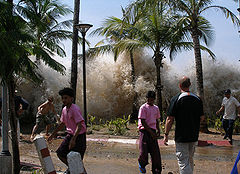
Tsunami strikes Ao Nang, Thailand.Date 00:58:53, December 26, 2004 (UTC) (2004-12-26T00:58:53Z) Magnitude 9.1–9.3 Mw Depth 30 km (19 mi) Epicenter 3°18′58″N 95°51′14″E / 3.316°N 95.854°E / 3.316; 95.854Coordinates: 3°18′58″N 95°51′14″E / 3.316°N 95.854°E / 3.316; 95.854 Type Undersea (subduction) Countries or regions Indonesia (mainly in Aceh)
Sri Lanka
India (mostly in Tamil Nadu)
Thailand
Maldives
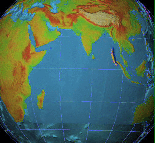
Eastern coast of Africa (mostly by tsunami, especially SomaliaTsunami Yes Casualties 230,210 - 310,000 deaths[1][2] (the sixth deadliest earthquake in recorded history) The 2004 Indian Ocean earthquake was an undersea megathrust earthquake that occurred at 00:58:53 UTC on Sunday, December 26, 2004, with an epicentre off the west coast of Sumatra, Indonesia. The quake itself is known by the scientific community as the Sumatra-Andaman earthquake.[3][4] The resulting tsunami is given various names, including the 2004 Indian Ocean tsunami, South Asian Tsunami, Indonesian Tsunami, and Boxing Day Tsunami.
The earthquake was caused by subduction and triggered a series of devastating tsunamis along the coasts of most landmasses bordering the Indian Ocean, killing over 230,000 people in fourteen countries, and inundating coastal communities with waves up to 30 meters (98 ft) high.[5] It was one of the deadliest natural disasters in recorded history. Indonesia was the hardest hit, followed by Sri Lanka, India, and Thailand.
With a magnitude of Mw 9.1–9.3, it is the third largest earthquake ever recorded on a seismograph. This earthquake had the longest duration of faulting ever observed, between 8.3 and 10 minutes. It caused the entire planet to vibrate as much as 1 centimetre (0.4 inches)[6] and triggered other earthquakes as far away as Alaska.[7] Its epicentre was between Simeulue and mainland Indonesia.[8]
The plight of the affected people and countries prompted a worldwide humanitarian response. In all, the worldwide community donated more than $14 billion (2004 U.S. dollars) in humanitarian aid.[9]
Contents
Earthquake characteristics
2004 Indian Ocean
earthquake
Events
Response
See also
v · earthquake was initially documented as moment magnitude 8.8. In February 2005 scientists revised the estimate of the magnitude to 9.0.[10] Although the Pacific Tsunami Warning Center has accepted these new numbers, the United States Geological Survey has so far not changed its estimate of 9.1. The most recent studies in 2006 have obtained a magnitude of Mw 9.1–9.3. Dr. Hiroo Kanamori of the California Institute of Technology believes that Mw 9.2 is a good representative value for the size of this great earthquake.[11]The hypocentre of the main earthquake was approximately 160 km (100 mi), in the Indian Ocean just north of Simeulue island, off the western coast of northern Sumatra, at a depth of 30 km (19 mi) below mean sea level (initially reported as 10 km (6.2 mi)). The northern section of the Sunda megathrust, which had been assumed dormant, ruptured; the rupture having a length of 1,300 km (810 mi).[8] The earthquake (followed by the tsunami) was felt simultaneously as far away as Bangladesh, India, Malaysia, Myanmar, Thailand, Singapore and the Maldives.[12] Splay faults, or secondary "pop up faults", caused long, narrow parts of the sea floor to pop up in seconds. This quickly elevated the height and increased the speed of waves, causing the complete destruction of the nearby Indonesian town of Lhoknga. [13]
 The epicentre of the earthquake, just north of Simeulue Island.
Indonesia lies between the Pacific Ring of Fire along the north-eastern islands adjacent to and including New Guinea and the Alpide belt along the south and west from Sumatra, Java, Bali, Flores, and Timor.
Great earthquakes such as the Sumatra-Andaman event, which are invariably associated with megathrust events in subduction zones, have seismic moments that can account for a significant fraction of the global earthquake moment across century-scale time periods. The Sumatra-Andaman earthquake was the largest earthquake since 1964, and the second largest since the Kamchatka earthquake of October 16, 1737.
Of all the seismic moment released by earthquakes in the 100 years from 1906 through 2005, roughly one-eighth was due to the Sumatra-Andaman event. This quake, together with the Good Friday Earthquake (Alaska, 1964) and the Great Chilean Earthquake (1960), account for almost half of the total moment. The much smaller but still catastrophic 1906 San Francisco earthquake is included in the diagram below for perspective. Mw denotes the magnitude of an earthquake on the moment magnitude scale.
Since 1900 the only earthquakes recorded with a greater magnitude were the 1960 Great Chilean Earthquake (magnitude 9.5) and the 1964 Good Friday Earthquake in Prince William Sound (9.2). The only other recorded earthquakes of magnitude 9.0 or greater were off Kamchatka, Russia, on November 4, 1952 (magnitude 9.0)[14] and Tōhoku, Japan (magnitude 9.0) on March 11, 2011. Each of these megathrust earthquakes also spawned tsunamis in the Pacific Ocean. However, the death toll from these was significantly lower, primarily because of the lower population density along the coasts near affected areas and the much greater distances to more populated coasts and also due to the superior infrastructure and warning systems in MEDCs (More Economically Developed Countries) such as Japan.
Other very large megathrust earthquakes occurred in 1868 (Peru, Nazca Plate and South American Plate); 1827 (Colombia, Nazca Plate and South American Plate); 1812 (Venezuela, Caribbean Plate and South American Plate) and 1700 (western North America, Juan de Fuca Plate and North American Plate). All of them are believed to be greater than magnitude 9, but no accurate measurements were available at the time.
Tectonic plates
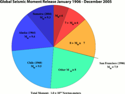 A pie chart comparing the seismic moment release for the largest earthquakes from 1906 to 2005 compared to all other earthquakes for the same periodMain article: plate tectonics
The megathrust earthquake was unusually large in geographical and geological extent. An estimated 1,600 kilometres (1,000 mi) of fault surface slipped (or ruptured) about 15 metres (50 ft) along the subduction zone where the India Plate slides (or subducts) under the overriding Burma Plate. The slip did not happen instantaneously but took place in two phases over a period of several minutes:
- Seismographic and acoustic data indicate that the first phase involved a rupture about 400 kilometres (250 mi) long and 100 kilometres (60 mi) wide, located 30 kilometers (19 mi) beneath the sea bed—the largest rupture ever known to have been caused by an earthquake. The rupture proceeded at a speed of about 2.8 kilometres per second (1.7 miles per second) (10,000 km/h or 6,200 mph), beginning off the coast of Aceh and proceeding north-westerly over a period of about 100 seconds.
- A pause of about another 100 seconds took place before the rupture continued northwards towards the Andaman and Nicobar Islands. However, the northern rupture occurred more slowly than in the south, at about 2.1 km/s (1.3 mi/s) (7,500 km/h or 4,700 mph), continuing north for another five minutes to a plate boundary where the fault type changes from subduction to strike-slip (the two plates slide past one another in opposite directions).
The India Plate is part of the great Indo-Australian Plate, which underlies the Indian Ocean and Bay of Bengal, and is drifting north-east at an average of 6 centimetres per year (2.4 inches per year). The India Plate meets the Burma Plate (which is considered a portion of the great Eurasian Plate) at the Sunda Trench. At this point the India Plate subducts beneath the Burma Plate, which carries the Nicobar Islands, the Andaman Islands, and northern Sumatra. The India Plate sinks deeper and deeper beneath the Burma Plate until the increasing temperature and pressure drive volatiles out of the subducting plate. These volatiles rise into the overlying plate causing partial melting and the formation of magma. The rising magma intrudes into the crust above and exits the Earth's crust through volcanoes in the form of a volcanic arc. The volcanic activity that results as the Indo-Australian Plate subducts the Eurasian Plate has created the Sunda Arc.
As well as the sideways movement between the plates, the sea floor is estimated to have risen by several metres, displacing an estimated 30 cubic kilometres (7.2 cu mi) of water and triggering devastating tsunami waves. The waves did not originate from a point source, as was inaccurately depicted in some illustrations of their paths of travel, but rather radiated outwards along the entire 1,600-kilometre (1,000 mi) length of the rupture (acting as a line source). This greatly increased the geographical area over which the waves were observed, reaching as far as Mexico, Chile, and the Arctic. The raising of the sea floor significantly reduced the capacity of the Indian Ocean, producing a permanent rise in the global sea level by an estimated 0.1 millimetres (0.004 in).[15]
Aftershocks and other earthquakes
 Locations of initial earthquake and all aftershocks measuring greater than 4.0 from December 26, 2004 to January 10, 2005. The site of the original quake is marked by the large star in the lower right square of the grid.
Numerous aftershocks were reported off the Andaman Islands, the Nicobar Islands and the region of the original epicentre in the hours and days that followed. The magnitude 8.7 2005 Sumatra earthquake, which originated off the coast of the Sumatran island of Nias, is not considered an aftershock, despite its proximity to the epicenter, and was most likely triggered by stress changes associated with the 2004 event.[16] This earthquake was so large that it produced its own aftershocks (some registering a magnitude of as great as 6.1) and presently ranks as the 7th largest earthquake on record since 1900. Other aftershocks of up to magnitude 6.6 continued to shake the region daily for up to three or four months.[17][18] As well as continuing aftershocks, the energy released by the original earthquake continued to make its presence felt well after the event. A week after the earthquake, its reverberations could still be measured, providing valuable scientific data about the Earth's interior.
The 2004 Indian Ocean earthquake came just three days after a magnitude 8.1 earthquake in an uninhabited region west of New Zealand's sub-Antarctic Auckland Islands, and north of Australia's Macquarie Island. This is unusual, since earthquakes of magnitude 8 or more occur only about once per year on average.[19] Some seismologists have speculated about a connection between these two earthquakes, saying that the former one might have been a catalyst to the Indian Ocean earthquake, as the two earthquakes happened on opposite sides of the Indo-Australian Plate. However, the U.S. Geological Survey sees no evidence of a causal relationship in this incident. Coincidentally, the earthquake struck almost exactly one year (to the hour) after a 6.6 magnitude earthquake killed an estimated 30,000 people in the city of Bam in Iran on December 26, 2003.[20]
Some scientists confirm that the December earthquake had activated Leuser Mountain, a volcano in Aceh province along the same range of peaks as Mount Talang, while the 2005 Sumatra earthquake had sparked activity in Lake Toba, an ancient crater in Sumatra.[21] Geologists say that the eruption of Mount Talang in April 2005 is connected to the December earthquake.[22]
Energy released
The energy released on the Earth's surface only (ME, which is the seismic potential for damage) by the 2004 Indian Ocean earthquake and tsunami was estimated at 1.1×10¹⁷ joules,[23] or 26.3 megatons of TNT. This energy is equivalent to over 1502 times that of the Hiroshima atomic bomb, but less than that of Tsar Bomba, the largest nuclear weapon ever detonated. However, this is but a tiny fraction of the total work done MW (and thus energy) by this quake, 4.0×10²² joules (4.0×1029 ergs),[24] the vast majority underground. This equates to 4.0×10²² J, over 363,000 times more than its ME. This is a truly enormous figure, equivalent to 9,560 gigatons of TNT equivalent (550 million times that of Hiroshima), or about 370 years of energy use in the United States at 2005 levels of 1.08×10²⁰ J.
The only recorded earthquakes with a larger MW were the 1960 Chilean and 1964 Alaskan quakes, with 2.5×10²³ joules (250 ZJ) and 7.5×10²² joules (75 ZJ) respectively.[25]
The earthquake generated a seismic oscillation of the Earth's surface of up to 20–30 cm (8–12 in), equivalent to the effect of the tidal forces caused by the Sun and Moon. The shock waves of the earthquake were felt across the planet; as far away as the U.S. state of Oklahoma, where vertical movements of 3 mm (0.12 in) were recorded. By February 2005, the earthquake's effects were still detectable as a 20 µm (0.02 mm; 0.0008 in) complex harmonic oscillation of the Earth's surface, which gradually diminished and merged with the incessant free oscillation of the Earth more than 4 months after the earthquake.[26]
Because of its enormous energy release and shallow rupture depth, the earthquake generated remarkable seismic ground motions around the globe, particularly due to huge Rayleigh (surface) elastic waves that exceeded 1 cm (0.4 in) in vertical amplitude everywhere on Earth. The record section plot below displays vertical displacements of the Earth's surface recorded by seismometers from the IRIS/USGS Global Seismographic Network plotted with respect to time (since the earthquake initiation) on the horizontal axis, and vertical displacements of the Earth on the vertical axis (note the 1 cm scale bar at the bottom for scale). The seismograms are arranged vertically by distance from the epicenter in degrees. The earliest, lower amplitude, signal is that of the compressional (P) wave, which takes about 22 minutes to reach the other side of the planet (the antipode; in this case near Ecuador). The largest amplitude signals are seismic surface waves that reach the antipode after about 100 minutes. The surface waves can be clearly seen to reinforce near the antipode (with the closest seismic stations in Ecuador), and to subsequently encircle the planet to return to the epicentral region after about 200 minutes. A major aftershock (magnitude 7.1) can be seen at the closest stations starting just after the 200 minute mark. This aftershock would be considered a major earthquake under ordinary circumstances, but is dwarfed by the mainshock.
 Vertical-component ground motions recorded by the IRIS/USGS Global Seismographic Network.
The shift of mass and the massive release of energy very slightly altered the Earth's rotation. The exact amount is not yet known, but theoretical models suggest the earthquake shortened the length of a day by 2.68 microseconds, due to a decrease in the oblateness of the Earth.[27] It also caused the Earth to minutely "wobble" on its axis by up to 2.5 cm (1 in) in the direction of 145° east longitude,[28] or perhaps by up to 5 or 6 cm (2.0 or 2.4 in).[29] However, because of tidal effects of the Moon, the length of a day increases at an average of 15 µs per year, so any rotational change due to the earthquake will be lost quickly. Similarly, the natural Chandler wobble of the Earth, which in some cases can be up to 15 m (50 ft), will eventually offset the minor wobble produced by the earthquake.
More spectacularly, there was 10 m (33 ft) movement laterally and 4–5 m (13–16 ft) vertically along the fault line. Early speculation was that some of the smaller islands south-west of Sumatra, which is on the Burma Plate (the southern regions are on the Sunda Plate), might have moved south-west by up to 36 m (120 ft), but more accurate data released more than a month after the earthquake found the movement to be about 20 cm (8 in).[30] Since movement was vertical as well as lateral, some coastal areas may have been moved to below sea level. The Andaman and Nicobar Islands appear to have shifted south-west by around 1.25 m (4 ft 1 in) and to have sunk by 1 m (3 ft 3 in).[31]
In February 2005, the Royal Navy vessel HMS Scott surveyed the seabed around the earthquake zone, which varies in depth between 1,000 and 5,000 m (550 and 2,700 fathoms; 3,300 and 16,000 ft). The survey, conducted using a high-resolution, multi-beam sonar system, revealed that the earthquake had made a huge impact on the topography of the seabed. 1,500-metre-high (5,000 ft) thrust ridges created by previous geologic activity along the fault had collapsed, generating landslides several kilometers wide. One such landslide consisted of a single block of rock some 100 m high and 2 km long (300 ft by 1.25 mi). The momentum of the water displaced by tectonic uplift had also dragged massive slabs of rock, each weighing millions of tons, as far as 10 km (6 mi) across the seabed. An oceanic trench several kilometres wide was exposed in the earthquake zone.[32]
The TOPEX/Poseidon and Jason 1 satellites happened to pass over the tsunami as it was crossing the ocean.[33] These satellites carry radars that measure precisely the height of the water surface; anomalies of the order of 50 cm (20 in) were measured. Measurements from these satellites may prove invaluable for the understanding of the earthquake and tsunami.[34] Unlike data from tide gauges installed on shores, measurements obtained in the middle of the ocean can be used for computing the parameters of the source earthquake without having to compensate for the complex ways in which close proximity to the coast changes the size and shape of a wave.
Tsunami characteristics
 Animation of the tsunami caused by the earthquake showing how the tsunami radiated from the entire length of the 1,600 km (990 mi) rupture.
 Scale showing the size of the tsunami waves that hit Indonesia.
The sudden vertical rise of the seabed by several metres during the earthquake displaced massive volumes of water, resulting in a tsunami that struck the coasts of the Indian Ocean. A tsunami which causes damage far away from its source is sometimes called a teletsunami and is much more likely to be produced by vertical motion of the seabed than by horizontal motion.[35]
The tsunami, like all others, behaved very differently in deep water than in shallow water. In deep ocean water, tsunami waves form only a small hump, barely noticeable and harmless, which generally travels at a very high speed of 500 to 1,000 km/h (310 to 620 mph); in shallow water near coastlines, a tsunami slows down to only tens of kilometres per hour, but in doing so forms large destructive waves. Scientists investigating the damage in Aceh found evidence that the wave reached a height of 24 metres (80 ft) when coming ashore along large stretches of the coastline, rising to 30 metres (100 ft) in some areas when travelling inland.[5]
Radar satellites recorded the heights of tsunami waves in deep water: at two hours after the earthquake, the maximum height was 60 centimetres (2 ft). These are the first such observations ever made. Unfortunately these observations could not be used to provide a warning, since the satellites were not built for that purpose and the data took hours to analyze.[36][37]
According to Tad Murty, vice-president of the Tsunami Society, the total energy of the tsunami waves was equivalent to about five megatons of TNT (20 petajoules). This is more than twice the total explosive energy used during all of World War II (including the two atomic bombs), but still a couple of orders of magnitude less than the energy released in the earthquake itself. In many places the waves reached as far as 2 km (1.2 mi) inland.[38]
 Tsunami wave field in the Bay of Bengal one hour after the M=9.2 earthquake. View to the northwest.
Because the 1,600 km (1,000 mi) fault affected by the earthquake was in a nearly north-south orientation, the greatest strength of the tsunami waves was in an east-west direction. Bangladesh, which lies at the northern end of the Bay of Bengal, had very few casualties despite being a low-lying country relatively near the epicenter. It also benefited from the fact that the earthquake proceeded more slowly in the northern rupture zone, greatly reducing the energy of the water displacements in that region.
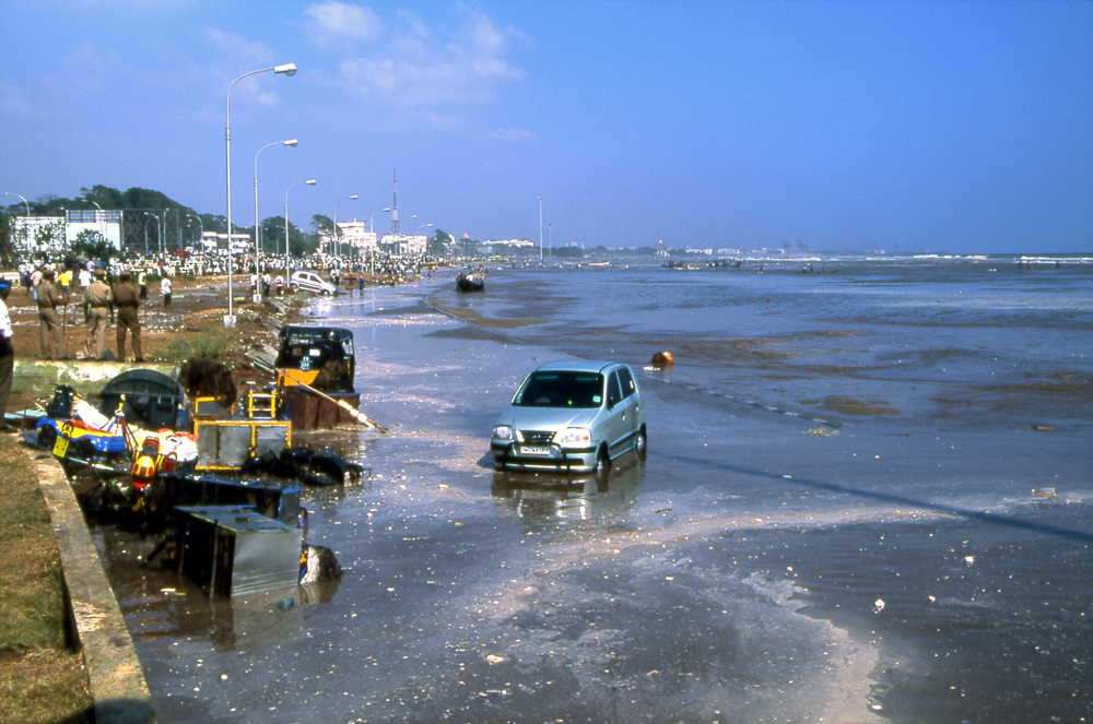
Coasts that have a landmass between them and the tsunami's location of origin are usually safe; however, tsunami waves can sometimes diffract around such landmasses. Thus, the Indian state of Kerala was hit by the tsunami despite being on the western coast of India, and the western coast of Sri Lanka also suffered substantial impacts. Also distance alone was no guarantee of safety; Somalia was hit harder than Bangladesh despite being much farther away.
Because of the distances involved, the tsunami took anywhere from fifteen minutes to seven hours (for Somalia) to reach the various coastlines.[39][40] The northern regions of the Indonesian island of Sumatra were hit very quickly, while Sri Lanka and the east coast of India were hit roughly 90 minutes to two hours later. Thailand was also struck about two hours later despite being closer to the epicentre, because the tsunami travelled more slowly in the shallow Andaman Sea off its western coast.
The tsunami was noticed as far as Struisbaai in South Africa, some 8,500 km (5,300 mi) away, where a 1.5 m (5 ft) high tide surged on shore about 16 hours after the earthquake. It took a relatively long time to reach this spot at the southernmost point of Africa, probably because of the broad continental shelf off South Africa and because the tsunami would have followed the South African coast from east to west. The tsunami also reached Antarctica, where tidal gauges at Japan's Showa Base recorded oscillations of up to a metre (3 ft 3 in), with disturbances lasting a couple of days.[41]
Some of the tsunami's energy escaped into the Pacific Ocean, where it produced small but measurable tsunamis along the western coasts of North and South America, typically around 20 to 40 cm (7.9 to 16 in).[42] At Manzanillo, Mexico, a 2.6 m (8 ft 6 in) crest-to-trough tsunami was measured. As well, the tsunami was large enough to be detected in Vancouver, British Columbia, Canada. This puzzled many scientists, as the tsunamis measured in some parts of South America were larger than those measured in some parts of the Indian Ocean. It has been theorized that the tsunamis were focused and directed at long ranges by the mid-ocean ridges which run along the margins of the continental plates.[43]
Signs and warnings
 Maximum recession of tsunami waters at Kata Noi Beach, Thailand, before the third, and strongest, tsunami wave (sea visible in the right corner, the beach is at the extreme left), 10:25 a.m. local time.
Despite a lag of up to several hours between the earthquake and the impact of the tsunami, nearly all of the victims were taken completely by surprise. There were no tsunami warning systems in the Indian Ocean to detect tsunamis or to warn the general populace living around the ocean. Tsunami detection is not easy because while a tsunami is in deep water it has little height and a network of sensors is needed to detect it. Setting up the communications infrastructure to issue timely warnings is an even bigger problem, particularly in a relatively poor part of the world.
Tsunamis are much more frequent in the Pacific Ocean because of earthquakes in the "Ring of Fire", and an effective tsunami warning system has long been in place there. Although the extreme western edge of the Ring of Fire extends into the Indian Ocean (the point where this earthquake struck), no warning system exists in that ocean. Tsunamis there are relatively rare despite earthquakes being relatively frequent in Indonesia. The last major tsunami was caused by the Krakatoa eruption of 1883. It should be noted that not every earthquake produces large tsunamis; on March 28, 2005, a magnitude 8.7 earthquake hit roughly the same area of the Indian Ocean but did not result in a major tsunami.
In the aftermath of the disaster, there is now an awareness of the need for a tsunami warning system for the Indian Ocean. The United Nations started working on an Indian Ocean Tsunami Warning System and by 2005 had the initial steps in place. Some have even proposed creating a unified global tsunami warning system, to include the Atlantic Ocean and Caribbean.
The first warning sign of a possible tsunami is the earthquake itself. However, tsunami can strike thousands of kilometres away where the earthquake is only felt weakly or not at all. Also, in the minutes preceding a tsunami strike, the sea often recedes temporarily from the coast. Around the Indian Ocean, this rare sight reportedly induced people, especially children, to visit the coast to investigate and collect stranded fish on as much as 2.5 km (1.6 mi) of exposed beach, with fatal results.[44] However, not all tsunami causes this "disappearing sea" effect. In some cases, there are no warning signs at all: the sea will suddenly swell without retreating, surprising many people and giving them little time to flee.
One of the few coastal areas to evacuate ahead of the tsunami was on the Indonesian island of Simeulue, very close to the epicentre. Island folklore recounted an earthquake and tsunami in 1907, and the islanders fled to inland hills after the initial shaking yet before the tsunami struck.[45] On Maikhao beach in northern Phuket, Thailand, a 10-year-old British tourist named Tilly Smith had studied tsunami in geography at school and recognised the warning signs of the receding ocean and frothing bubbles. She and her parents warned others on the beach, which was evacuated safely.[46] John Chroston, a biology teacher from Scotland, also recognised the signs at Kamala Bay north of Phuket, taking a busload of vacationers and locals to safety on higher ground.
Anthropologists had initially expected the aboriginal population of the Andaman Islands to be badly affected by the tsunami and even feared the already depopulated Onge tribe could have been wiped out. Of the six native tribes only the Nicobarese, who had converted to Christianity and taken up agriculture in place of their previous hunter-gatherer lifestyle, and mainland settlers suffered significant losses.[47] Many of the aboriginal tribes evacuated and suffered fewer casualties.[48][49]
Phases and wave form
 USGS graphics showing the wave structure of the 2004 Indian Ocean tsunami. Red indicate a positive wave form while blue represent a negative wave form.
A tsunami can arrive at a coastline in one of two ways. In the first form, a negative wave, a trough precedes the actual arrival of the crest or "wave" itself. Here, the more common and better recognized warning sign of an impending tsunami strike is a rapidly receding sea followed by a sudden onrushing body of water traveling inland at high speed.
The second form in which a tsunami arrives is the positive wave or crest first. In this case, the warning signs are much more vague if any. The sea will usually start rising immediately, slowly at first without the receding phase, like an on-coming high tide. However, instead of stopping at tidal level, the sea will keep rising faster and faster until the crest of the tsunami passes and continues moving inland. The second form of tsunami waves are usually more dangerous, since they can arrive without easily identifiable warning, giving residents less time to prepare and outrun the tsunami. These two types of tsunamis are usually generated simultaneously (in opposing direction of travel) by a megathrust earthquake similar to the 2004 Indian Ocean earthquake.
Retreat-rise cycle (negative wave)
The tsunami was a succession of several waves, occurring in retreat and rise cycles with a period of over 30 minutes between each peak. The third wave was the most powerful and reached highest, occurring about an hour and a half after the first wave.
Rise-retreat-rise cycle (positive wave)
If the crest of a tsunami arrives first, there won't be any recession. The sea level will increase rapidly to inundate everything in the path of the tsunami. This appears to be the case in countries such as Sri Lanka and India that lies to the west of the Andaman-Sumatra fault where the tsunami originates.
-

Second tsunami wave starting to retreat, Kata Noi Beach, Thailand, 10:17 a.m.
-

Receding waters after the second tsunami, 10:20 a.m.
-

3rd tsunami wave, 11:00 a.m.
-

4th tsunami wave, 11:22 a.m.
Death toll and casualties

According to the U.S. Geological Survey a total of 227,898 people died (see table below for details).[50] Measured in lives lost, this is one of the ten worst earthquakes in recorded history, as well as the single worst tsunami in history. Indonesia was the worst affected area, with most death toll estimates at around 170,000.[51] However, another report by health minister Fadilah Supari has estimated the death total to be as high as 220,000 in Indonesia alone, giving a total of 280,000 casualties.[52]
The tsunami caused serious damage and deaths as far as the east coast of Africa, with the farthest recorded death due to the tsunami occurring at Rooi Els in South Africa, 8,000 km (5,000 mi) away from the epicentre. In total, eight people in South Africa died due to abnormally high sea levels and waves.
Relief agencies report that one-third of the dead appear to be children. This is a result of the high proportion of children in the populations of many of the affected regions and because children were the least able to resist being overcome by the surging waters. Oxfam went on to report that as many as four times more women than men were killed in some regions because they were waiting on the beach for the fishermen to return and looking after their children in the houses.[53]
In an addition to the large number of local residents, up to 9,000 foreign tourists (mostly Europeans) enjoying the peak holiday travel season were among the dead or missing, especially people from the Nordic countries. The European nation hardest hit may have been Sweden, whose death toll was 543.[54]
States of emergency were declared in Sri Lanka, Indonesia, and the Maldives. The United Nations estimated at the outset that the relief operation would be the costliest in human history. Then UN Secretary-General Kofi Annan stated that reconstruction would probably take between five and ten years. Governments and non-governmental organisations feared that the final death toll might double as a result of diseases, prompting a massive humanitarian response. In the end, this fear did not materialise.
For purposes of establishing timelines of local events, the time zones of affected areas are: UTC+3: (Kenya, Madagascar, Somalia, Tanzania); UTC+4: (Mauritius, Réunion, Seychelles); UTC+5: (Maldives); UTC+5:30: (India, Sri Lanka); UTC+6: (Bangladesh); UTC+6:30: (Cocos Islands, Myanmar); UTC+7: (Indonesia (western), Thailand); UTC+8: (Malaysia, Singapore). Since the earthquake occurred at 00:58:53 UTC, add the above offsets to find the local time of the earthquake.
Country where
deaths occurredConfirmed Estimated1 Injured Missing Displaced Indonesia 130,736 167,799 n/a 37,063[55] 500,000+[56] Sri Lanka2 35,322[57] 35,322 21,411[57] n/a 516,150[57] India 12,405 18,045 n/a 5,640 647,599 Thailand 5,3953[58] 8,212 8,457[59] 2,817[58] 7,000 Somalia 78 289[60] n/a n/a 5,000[61] Myanmar (Burma) 61[55] 400–600[2] 45 200[62] 3,200 Maldives 82[63] 108[64] n/a 26 15,000+ Malaysia 68[65] 75 299[66] 6 n/a Tanzania 10[67] 13 n/a n/a n/a Seychelles 3[68] 3 57[68] n/a 200[69] Bangladesh 2 2 n/a n/a n/a South Africa 24[70] 2 n/a n/a n/a Yemen 2[71] 2 n/a n/a n/a Kenya 1 1 2 n/a n/a Madagascar n/a n/a n/a n/a 1,000+[72] Total ~184,167 ~230,273 ~125,000 ~45,752 ~1.69 million Note: All figures are approximate and subject to change. The first column links to more details on specific countries.
1 Includes those reported under 'Confirmed'. If no separate estimates are available, the number in this column is the same as reported under 'Confirmed'.
2 Does not include approximately 19,000 missing people initially declared by Tamil Tiger authorities from regions under their control.
3 Data includes at least 2,464 foreigners.
4 Does not include South African citizens who died outside of South Africa (e.g., tourists in Thailand). For more information on those deaths, see thisCountries affected
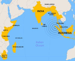 Countries most affected by the tsunami, with the earthquake's epicenter.Main article: Countries affected by the 2004 Indian Ocean earthquake
The earthquake and resulting tsunami affected many countries in Southeast Asia and beyond, including Indonesia, Sri Lanka, India, Thailand, the Maldives, Somalia, Myanmar, Malaysia, Seychelles and others. Many other countries, especially Australia and those in Europe, had large numbers of citizens traveling in the region on holiday. Both Sweden and Germany lost over 500 citizens each in the disaster.
Event in historical context
This earthquake was the biggest in the Indian Ocean in some 700 years, or since around A.D. 1400.[73][74] In 2008, a team of scientists working on Phra Thong, a barrier island along the hard-hit west coast of Thailand, reported evidence of at least three previous major tsunamis in the preceding 2,800 years, the most recent from about 550 to 700 years ago. A second team found similar evidence of previous tsunamis during the last 1,200 years in Aceh, a province at the northern tip of Sumatra. Radiocarbon dating of bark fragments in soil below the second sand layer led the scientists to estimate that the most recent predecessor to the 2004 tsunami probably occurred between A.D. 1300 and 1450.[75]
This earthquake was the third most powerful earthquake recorded since 1900, and the confirmed death toll is just under 200,000 due to the ensuing tsunami. The deadliest earthquakes since 1900 were the Tangshan, China earthquake of 1976, in which at least 255,000 were killed; the earthquake of 1927 in Xining, Qinghai, China (200,000); the Great Kanto earthquake which struck Tokyo in 1923 (143,000); and the Gansu, China, earthquake of 1920 (200,000). The deadliest known earthquake in history occurred in 1556 in Shaanxi, China, with an estimated death toll of 830,000, though figures from this time period may not be reliable.[76]
The 2004 tsunami is the deadliest in recorded history. Prior to 2004, the deadliest recorded tsunami in the Pacific Ocean was in 1782, when 40,000 people were killed by a tsunami in the South China Sea.[77] The tsunami created by the 1883 eruption of Krakatoa is thought to have resulted in 36,000 deaths. The most deadly tsunami between 1900 and 2004 occurred in 1908 in Messina, Italy, on the Mediterranean Sea, where the earthquake and tsunami killed 70,000. The most deadly tsunami in the Atlantic Ocean resulted from the 1755 Lisbon earthquake, which, combined with the toll from the actual earthquake and resulting fires, killed over 100,000.
The 2004 earthquake and tsunami combined have been described as the deadliest natural disaster since either the 1976 Tangshan earthquake or the 1970 Bhola cyclone, or could conceivably exceed both of these. Because of uncertainty over death tolls, it might never be known for sure which of these natural disasters was the deadliest.
Possible human component in magnitude of damage
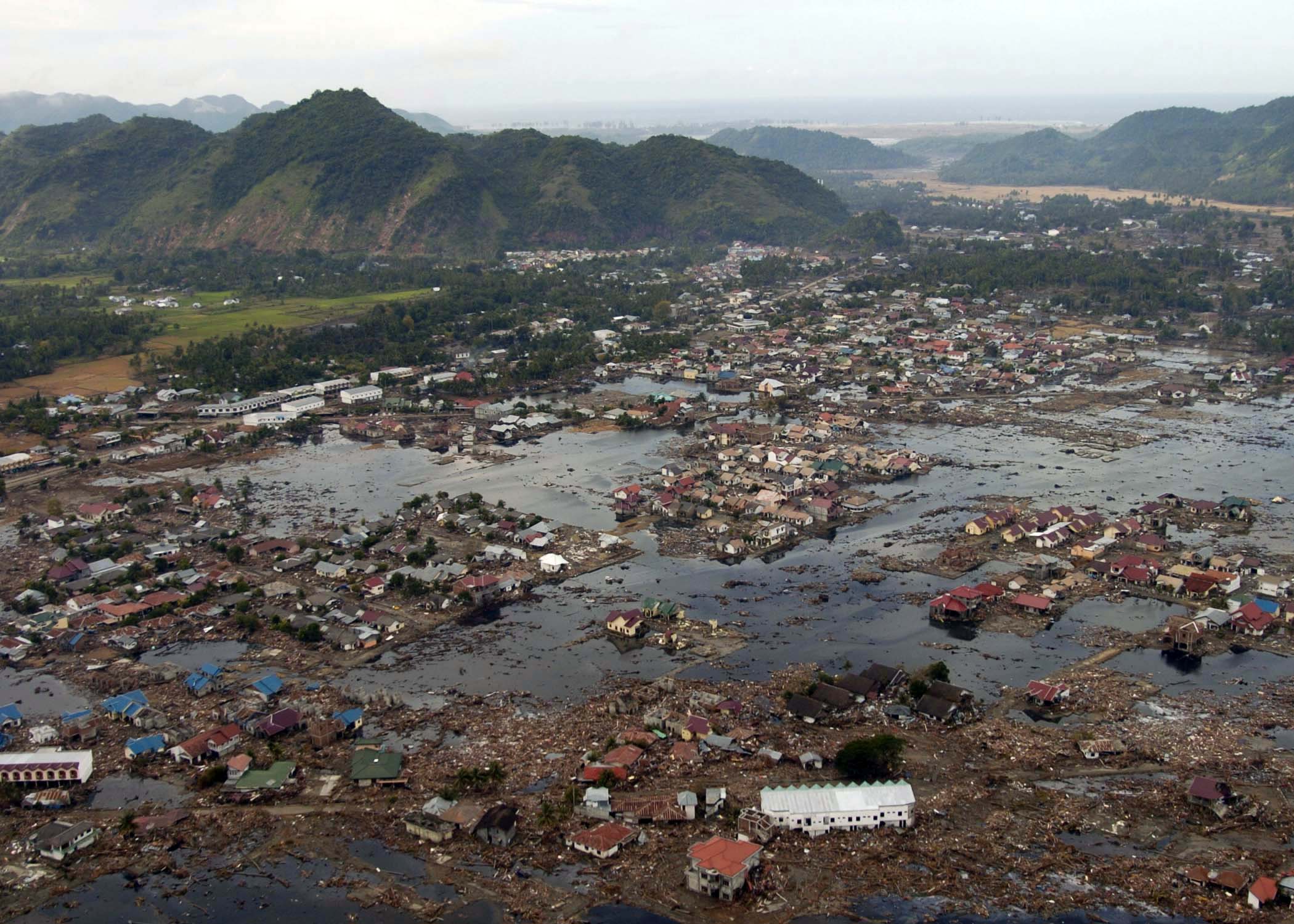
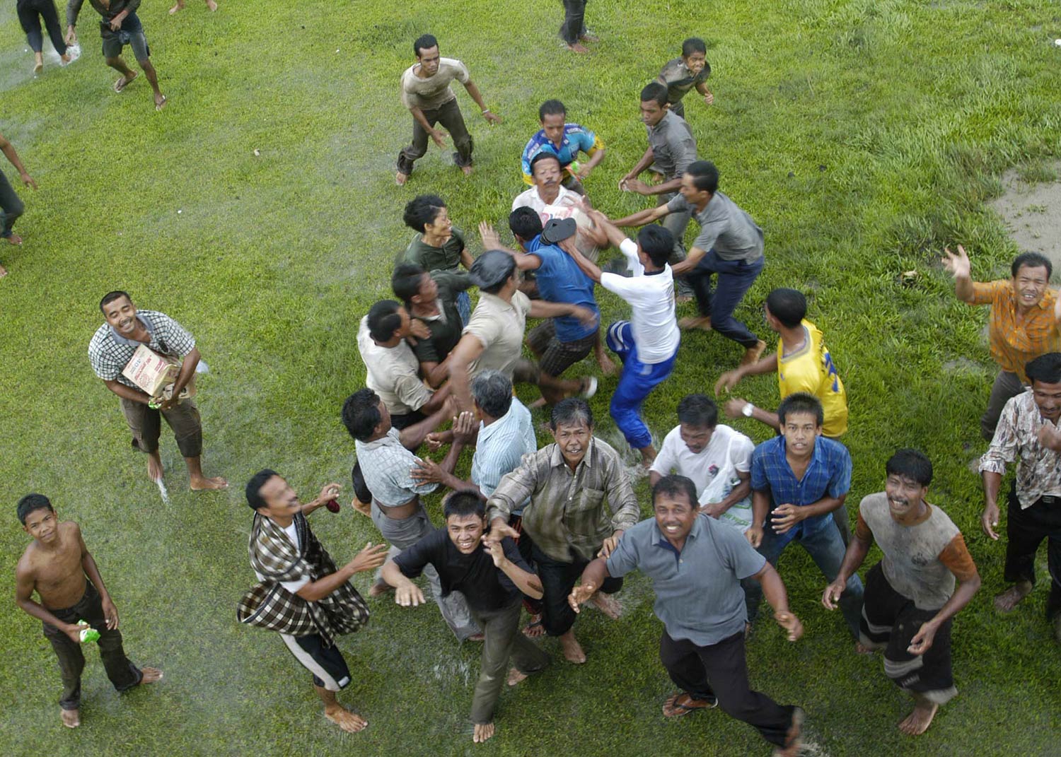
 A town near the coast of Sumatra lies in ruin on January 2, 2005. This picture was taken by a United States military helicopter crew from the USS Abraham Lincoln that was conducting humanitarian operations.
 Indonesians gather under an approaching helicopter to receive food and supplies.
In an opinion piece in the Wall Street Journal, published five days after the tsunami, a journalist, Andrew Browne, argued that the human destruction of coral reefs may have played a role in exacerbating the destruction caused by the tsunami. Many countries across Asia, including Indonesia, Sri Lanka and Bangladesh, have put forth efforts to destroy the coral surrounding their beaches, and instead make way for shrimp farms and other economic choices. On the Surin Island chain of Thailand's coast, Browne argued, people may have been saved as the tsunami rushed against the coral reefs, lessening its impact. However, there were many fewer people on these islands, which helps explain the lower death toll. Many reefs areas around the Indian Ocean have been destroyed using dynamite because they are considered impediments to shipping, an important part of the South Asian economy.[78] Similarly, Browne argued that the removal of coastal mangrove trees may have intensified the effect of the tsunami in some locations. He argued that these trees, which lined the coast but were removed to make way for coastal residences, might have lessened the force of the tsunami, in certain areas. Another factor, Browne argued, is the removal of coastal sand dunes.[78]
Humanitarian, economic and environmental impact
A great deal of humanitarian aid was needed because of widespread damage of the infrastructure, shortages of food and water, and economic damage. Epidemics were of special concern due to the high population density and tropical climate of the affected areas. The main concern of humanitarian and government agencies was to provide sanitation facilities and fresh drinking water to contain the spread of diseases such as cholera, diphtheria, dysentery, typhoid and hepatitis A and B.
There was also a great concern that the death toll could increase as disease and hunger spread. However, because of the initial quick response, this was minimized.[79]
In the days following the tsunami, significant effort was spent in burying bodies hurriedly for fear of disease. However, the public health risks may have been exaggerated, and therefore this may not have been the best way to allocate resources. The World Food Programme provided food aid to more than 1.3 million people affected by the tsunami.[80]
Further information: Health risks from dead bodiesNations all over the world provided over US$14 billion in aid for damaged regions,[81] with the governments of Australia pledging US$819.9 million (including a US$760.6-million aid package for Indonesia), Germany offering US$660 million, Japan offering US$500 million, Canada offering US$343 million, Norway and the Netherlands offering both US$183 million, the United States offering US$35 million initially (increased to US$350 million), and the World Bank offering US$250 million. Also Italy offered US$95 million, increased later to US$113 million of which US$42 million was donated by the population using the SMS system[82] According to USAID, the US has pledged additional funds in long-term U.S. support to help the tsunami victims rebuild their lives. On February 9, 2005, President Bush asked Congress to increase the U.S. commitment to a total of $950 million. Officials estimated that billions of dollars would be needed. Bush also asked his father, former President George H. W. Bush, and former President Bill Clinton to lead a U.S. effort to provide private aid to the tsunami victims.[83]
In mid-March the Asian Development Bank reported that over US$4 billion in aid promised by governments was behind schedule. Sri Lanka reported that it had received no foreign government aid, while foreign individuals had been generous.[84] Many charities were given considerable donations from the public. For example, in the UK the public donated roughly £330,000,000 sterling (nearly US$600,000,000). This considerably outweighed the donation by the government and came to an average of about £5.50 (US$10) donated by every citizen.
In August 2006, fifteen local aid staff working on post-tsunami rebuilding were found executed in northeast Sri Lanka after heavy fighting, the main umbrella body for aid agencies in the country said. There had been reports and rumors that the local aid workers had been killed.
Economic impact
The impact on coastal fishing communities and the people living there, some of the poorest in the region, has been devastating with high losses of income earners as well as boats and fishing gear.[85] In Sri Lanka artisanal fishery, where the use of fish baskets, fishing traps, and spears are commonly used, is an important source of fish for local markets; industrial fishery is the major economic activity, providing direct employment to about 250,000 people. In recent years the fishery industry has emerged as a dynamic export-oriented sector, generating substantial foreign exchange earnings. Preliminary estimates indicate that 66% of the fishing fleet and industrial infrastructure in coastal regions have been destroyed by the wave surges, which will have adverse economic effects both at local and national levels.[86]
The tsunami created demand for fiberglass reinforced plastic catamarans in boatyards of Tamil Nadu.[87]
But some economists believe that damage to the affected national economies will be minor because losses in the tourism and fishing industries are a relatively small percentage of the GDP. However, others caution that damage to infrastructure is an overriding factor. In some areas drinking water supplies and farm fields may have been contaminated for years by salt water from the ocean.[88]
Both the earthquake and the tsunami may have affected shipping in the Malacca Straits by changing the depth of the seabed and by disturbing navigational buoys and old shipwrecks. Compiling new navigational charts may take months or years.[89]
Countries in the region appealed to tourists to return, pointing out that most tourist infrastructure is undamaged. However, tourists were reluctant to do so for psychological reasons. Even beach resorts in parts of Thailand which were completely untouched by the tsunami were hit by cancellations.[90]
Environmental impact
 Tsunami inundation, Khao Lak, North of Phuket, Thailand ASTER Images and SRTM Elevation Model.
Beyond the heavy toll on human lives, the Indian Ocean earthquake has caused an enormous environmental impact that will affect the region for many years to come. It has been reported that severe damage has been inflicted on ecosystems such as mangroves, coral reefs, forests, coastal wetlands, vegetation, sand dunes and rock formations, animal and plant biodiversity and groundwater. In addition, the spread of solid and liquid waste and industrial chemicals, water pollution and the destruction of sewage collectors and treatment plants threaten the environment even further, in untold ways. The environmental impact will take a long time and significant resources to assess.[91]
According to specialists, the main effect is being caused by poisoning of the freshwater supplies and the soil by saltwater infiltration and deposit of a salt layer over arable land. It has been reported that in the Maldives, 16 to 17 coral reef atolls that were overcome by sea waves are completely without fresh water and could be rendered uninhabitable for decades. Uncountable wells that served communities were invaded by sea, sand and earth; and aquifers were invaded through porous rock. Salted-over soil becomes sterile, and it is difficult and costly to restore for agriculture. It also causes the death of plants and important soil micro-organisms. Thousands of rice, mango and banana plantations in Sri Lanka were destroyed almost entirely and will take years to recover. On the island's east coast, the tsunami contaminated wells on which many villagers relied for drinking water. The Colombo-based International Water Management Institute monitored the effects of saltwater and concluded that the wells recovered to pre-tsunami drinking water quality one and a half years after the event.[92] IWMI developed protocols for cleaning wells contaminated by saltwater; these were subsequently officially endorsed by the World Health Organization as part of its series of Emergency Guidelines.[93]
The United Nations Environment Programme (UNEP) is working with governments of the region in order to determine the severity of the ecological impact and how to address it.[94] UNEP has decided to earmark a US$1,000,000 emergency fund and to establish a Task Force to respond to requests for technical assistance from countries affected by the tsunami.[95] In response to a request from the Maldivian Government, the Australian Government sent ecological experts to help restore marine environments and coral reefs—the lifeblood of Maldivian tourism. Much of the ecological expertise has been rendered from work with the Great Barrier Reef, in Australia's northeastern waters.
Other effects
Many health professionals and aid workers have reported widespread psychological trauma associated with the tsunami. Traditional beliefs in many of the affected regions state that a relative of the family must bury the body of the dead, and in many cases, no body remained to be buried.
The hardest hit area, Aceh, is considered to be a religiously conservative Islamic society and has had no tourism nor any Western presence in recent years due to armed conflict between the Indonesian military and Acehnese separatists. Some believe that the tsunami was divine punishment for lay Muslims shirking their daily prayers and/or following a materialistic lifestyle. Others have said that Allah was angry that there were Muslims killing other Muslims in an ongoing conflict.[96] Women in Aceh required a special approach from foreign aid agencies, and continue to have unique needs.
The widespread devastation caused by the tsunami led the main rebel group GAM to declare a cease-fire on December 28, 2004 followed by the Indonesian government, and the two groups resumed long-stalled peace talks, which resulted in a peace agreement signed August 15, 2005. The agreement explicitly cites the tsunami as a justification.[97]
The extensive international media coverage of the tsunami, and the role of mass media and journalists in reconstruction, were discussed by editors of newspapers and broadcast media in tsunami-affected areas, in special video-conferences set up by the Asia Pacific Journalism Centre.[98]
The December 26, 2004 Asian Tsunami left both the people and government of India in a state of heightened alert. On December 30, 2004, four days after the tsunami, the Portland, Oregon-based company Terra Research notified the India government that its sensors indicated there was a possibility of 7.9 to 8.1 magnitude tectonic shift in the next 12 hours between Sumatra and New Zealand.[99] In response, the India Home Affairs minister announced that a fresh onslaught of deadly tidal waves were likely along the India southern coast and Andaman and Nicobar Islands, even as there was no sign of turbulences in the region.[99] The announcement generated panic in the Indian Ocean region and caused thousands to flee their homes, which resulted in jammed roads.[100] The announcement was a false alarm and the Home Affairs minister withdrew their announcement.[100] On further investigation, the India government learned that the consulting company Terra Research was run from the home of a self-described earthquake forecaster who had no telephone listing and maintained a website where he sold copies of his detection system.[101] Three days after the announcement, Indian National Congress president Sonia Gandhi called Science & Technology minister Kapil Sibal to express her concern about Sibal's December 30 public warning being "hogwash".[102]
Another result of the tsunami, respective toward Indian culture, was the water that washed away centuries of sand from some of the ruins of a 1,200-year-old lost city at Mahabalipuram on the south coast of India. The site, containing such notable structures as a half-buried granite lion near a 7th century Mahablipuram temple and a relic depicting an elephant, is part of what archaeologists believe to be an ancient port city that was swallowed by the sea hundreds of years ago.[103][104]
The tsunami had a severe humanitarian and political impact in Sweden. The hardest hit country outside Asia, 543 Swedish tourists, mainly in Thailand, died. With no single incident having killed more Swedish people since the battle of Poltava in 1709, the cabinet of Göran Persson was heavily criticized for lack of action.
Apung 1, a 2600 ton ship, was flung some 2-3 km inland by the tsunami, and has become a popular tourist attraction in Banda Aceh.
See also

Disasters portal 
India portal 
Thailand portal 
Indonesia portal 
Sri Lanka portal 
Asia portal - Aceh Tsunami Museum
- Aid Still Required
- Children of the Tsunami: No More Tears (documentary film)
- Effect of the 2004 Indian Ocean earthquake on Hong Kong
- July 2006 Java earthquake
- List of earthquakes
- List of Indonesian earthquakes
- May 2006 Java earthquake
- Megathrust earthquake
- Megatsunami
- Plate tectonics
- Pornthip Rojanasunand, a prominent Thai doctor who took charge of ID of bodies
- Queen of the Sea rail disaster, caused by the tsunami was the deadliest rail disaster in history
- Seismology
- Seismotectonics
- 2011 Tōhoku earthquake and tsunami
- Tectonics
- Tsunami
- Tsunami: The Aftermath, a television miniseries about its after-effects
- Tsunami Evaluation Coalition
References
- ^ If the death toll in Myanmar was 400–600 as claimed by dissident groups there, rather than just 61 or 90, more than 230,000 people would have perished in total from the tsunami.
- ^ a b "Myanmar is withholding true casualties figures, says Thai priest". AsiaNews.it. web.archive.org. 2005-01-04. Archived from the original on 2006-10-09. http://web.archive.org/web/20061009053106/http://www.asianews.it/view.php?l=en&art=2255. Retrieved 2011-02-12. "A missioner in Ranong, a town on the border between Thailand and Myanmar, says locals talk about 600 victims. Burmese political dissidents say the same."
- ^ Lay, T., Kanamori, H., Ammon, C., Nettles, M., Ward, S., Aster, R., Beck, S., Bilek, S., Brudzinski, M., Butler, R., DeShon, H., Ekström, G., Satake, K., Sipkin, S., The Great Sumatra-Andaman Earthquake of December 26, 2004, Science, 308, 1127–1133, doi:10.1126/science.1112250, 2005
- ^ "Tsunamis and Earthquakes: Tsunami Generation from the 2004 Sumatra Earthquake — USGS Western Coastal and Marine Geology". Walrus.wr.usgs.gov. http://walrus.wr.usgs.gov/tsunami/sumatraEQ/. Retrieved 2010-08-12.
- ^ a b Paris, R.; Lavigne F., Wassimer P. & Sartohadi J. (2007). "Coastal sedimentation associated with the December 26, 2004 tsunami in Lhok Nga, west Banda Aceh (Sumatra, Indonesia)". Marine Geology (Elsevier) 238 (1–4): 93–106. doi:10.1016/j.margeo.2006.12.009. http://www.sciencedirect.com/science/article/pii/S0025322706003653. Retrieved 26 June 2011. [dead link]
- ^ Walton, Marsha. "Scientists: Sumatra quake longest ever recorded." CNN. May 20, 2005
- ^ West, Michael; Sanches, John J.; McNutt, Stephen R. "Periodically Triggered Seismicity at Mount Wrangell, Alaska, After the Sumatra Earthquake." Science. Vol. 308, No. 5725, 1144–1146. May 20, 2005.
- ^ a b Nalbant, S., Steacy, S., Sieh, K., Natawidjaja, D., and McCloskey, J. "Seismology: Earthquake risk on the Sunda trench." Nature. Vol. 435, No. 7043, 756–757. June 9, 2005. Accessed 2009-05-16. Archived 2009-05-18.
- ^ Jayasuriya, Sisira and Peter McCawley, "The Asian Tsunami: Aid and Reconstruction after a Disaster". Cheltenham UK and Northampton MA USA: Edward Elgar, 2010.
- ^ McKee, Maggie. "Power of tsunami earthquake heavily underestimated." New Scientist. February 9, 2005.
- ^ EERI Publication 2006–06, page 14.
- ^ Lovholt, F., Bungum, H., Harbitz, C.B., Glimsal, S., Lindholm, C.D., and Pedersen, G. "Earthquake related tsunami hazard along the western coast of Thailand." Natural Hazards and Earth System Sciences. Vol. 6, No. 6, 979–997. November 30, 2006. Accessed 2009-05-16. Archived 2009-05-18.
- ^ Sibuet, J-C., Rangin, C., Le Pichon, X., Singh, S., Cattaneo, A., Graindorge, D., Klingelhoefer, F., Lin, J-Y., Malod, J., Maury, T., Schneider, J-L., Sultan, N., Umber, M., Yamaguchi, H., and the “Sumatra aftershocks” team, "December 26, 2004 great Sumatra–Andaman earthquake: Co-seismic and post-seismic motions in northern Sumatra." Earth and Planetary Science Letters. Vol. 263, Issues. 1–2, 88–103. November 15, 2007. Accessed 2009-05-16. Archived 2009-05-18.
- ^ "Kamchatka Earthquake, November 4, 1952." United States Geological Survey.
- ^ Bilham, Roger. "A Flying Start, Then a Slow Slip." Science. Vol. 308, No. 5725, 1126–1127. May 20, 2005.
- ^ USGS (22 July 2010). "Poster of the Northern Sumatra Earthquake of 28 March 2005 - Magnitude 8.7". http://earthquake.usgs.gov/earthquakes/eqarchives/poster/2005/20050328.php. Retrieved 26 June 2011.
- ^ Staff Writer. "Sumatra shaken by new earthquake." BBC News. April 10, 2005.
- ^ "Panic in Sumatra after new earthquake." WIKINEWS. April 10, 2005. Archived 24 June 2007 at WebCite
- ^ USGS Earthquake Hazards Program: FAQ.
- ^ "Earthquake-Tsunami Event of Christmas/Boxing Day 2004: Frames of Alternative Analysis or Perception". http://www.ecologynews.com/ecologynews102.html. Retrieved 2006-04-22.
- ^ Rinaldo, Aditya. "Thousands flee as Indonesian volcano spews into life." Hindustan Times. April 12, 2005.
- ^ Johnston, Tim (April 13, 2005). "Indonesian Volcanoes Erupt; Thousands Evacuated". VOA News. http://www.theepochtimes.com/news/5-4-13/27829.html. Retrieved 2006-04-22.
- ^ "USGS Energy and Broadband Solution". Neic.usgs.gov. http://neic.usgs.gov/neis/eq_depot/2004/eq_041226/neic_slav_e.html. Retrieved 2010-08-12.
- ^ "USGS, Harvard Moment Tensor Solution". Neic.usgs.gov. 2004-12-26. http://neic.usgs.gov/neis/eq_depot/2004/eq_041226/neic_slav_hrv.html. Retrieved 2010-08-12.
- ^ "USGS:Measuring the size of earthquakes". Earthquake.usgs.gov. 2009-10-27. http://earthquake.usgs.gov/learning/topics/measure.php. Retrieved 2010-08-12.
- ^ Virtanen, H. (2006). Studies of earth dynamics with superconducting gravimeter. Academic Dissertation at the University of Helsinki. http://ethesis.helsinki.fi/julkaisut/mat/fysik/vk/virtanen/studieso.pdf. Retrieved September 21, 2009.
- ^ Cook-Anderson, Gretchen; Beasley, Dolores. "NASA Details Earthquake Effects on the Earth." National Aeronautics and Space Administration (press release). January 10, 2005.
- ^ Schechner, Sam. "Earthquakes vs. the Earth's Rotation." Slate. December 27, 2004.
- ^ Staff Writer. "Italian scientists say Asian quakes cause Earth's axis shifted." Xinhua. December 29, 2004.
- ^ Staff Writer (January 31, 2005). "Quake moved Sumatra by only 20 centimeters: Danish scientists". Agence France Presse.
- ^ Bagla, Pallava (January 28, 2005). "After the Earth Moved". Science Now.
- ^ Knight, Will. "Asian tsunami seabed pictured with sonar." New Scientist. February 10, 2005.
- ^ Staff Writer. "NASA/French Satellite Data Reveal New Details of Tsunami[dead link]." Jet Propulsion Laboratory/National Aeronautics and Space Administration. January 11, 2005.
- ^ TOPEX/Poseidon Satellite Data on the December 26, 2004 tsunami in the Indian Ocean. Aviso.
- ^ Lorca, Emilio; Recabarren, Margot (1997). Earthquakes and Tsunamis.
- ^ Leslie, John. "NOAA Scientists able to Measure Tsunami Height from Space." NOAA Magazine. January 10, 2005.
- ^ McKee, Maggie. "Radar satellites capture tsunami wave height." New Scientist. January 6, 2005.
- ^ Pearce, Fred; Holmes, Bob. "Tsunami: The impact will last for decades." New Scientist. January 15, 2005.
- ^ Time travel map: Tsunami Laboratory, Novosibirsk, Russia.[dead link]
- ^ Time travel map: Active Fault Research Center: National Institute of Advanced Industrial Science and Technology, Japan.
- ^ "Indian Ocean Tsunami" at Syowa Station, Antarctica, Hydrographic and Oceanographic Dept. Japan Coast Guard.
- ^ Indian Ocean Tsunami of 26 December, 2004. West Coast/Alaska Tsunami Warning Center (USGS). December 31, 2004.
- ^ Carey, Bjorn. "Tsunami Waves Channeled Around the Globe in 2004 Disaster." LiveScience. August 25, 2005.
- ^ Block, Melissa. "Sri Lankans Seek Lost Relatives After Tsunami." All Things Considered/NPR. December 27, 2004.
- ^ Campbell, Matthew; Loveard, Keith; et al. "Tsunami disaster: Focus: Nature's timebomb." Times Online. January 2, 2005.
- ^ Staff Writer. "Girl, 10, used geography lesson to save lives." news.telegraph. January 1, 2005.
- ^ Subir Bhaumik (Thursday, 30 December 2004). "Andaman aborigines' fate unclear". BBC News. http://news.bbc.co.uk/2/hi/south_asia/4135187.stm. Retrieved 2010-02-13.
- ^ Gupta, Manu; Sharma, Anshu (2006). "Compounded loss: the post tsunami recovery experience of Indian island communities". Disaster Prevention and Management 15 (1): 67–78. doi:10.1108/09653560610654248.
- ^ Math, Suresh Bada; Girimaji1, Satish Chandra; Benegal, V; Uday Kumar, GS; Hamza, A; Nagaraja, D (2006). "Tsunami: Psychosocial aspects of Andaman and Nicobar islands. Assessments and intervention in the early phase". International Review of Psychiatry 18 (3): 233–239. doi:10.1080/09540260600656001. PMID 16753660.
- ^ "USGS.gov". Earthquake.usgs.gov. http://earthquake.usgs.gov/earthquakes/eqinthenews/2004/usslav/#summary/. Retrieved 2010-08-12.
- ^ "Home". Islamic Relief USA. Archived from the original on 2011-01-17. http://www.islamicreliefusa.org/home?aspxerrorpath=/404.aspx. Retrieved 2010-08-12.
- ^ "(BBC)". BBC News. 2005-01-25. http://news.bbc.co.uk/1/hi/world/asia-pacific/4204385.stm. Retrieved 2010-08-12.
- ^ Staff Writer. "Most tsunami dead female - Oxfam." BBC News. March 26, 2005.
- ^ "Sweden aide quits over bar furore". BBC News. November 1, 2007. http://news.bbc.co.uk/2/hi/europe/7072934.stm. Retrieved 2008-07-27.
- ^ a b Sify.com[dead link]
- ^ Meisl, C.S.; Safaie S., Elwood K.J., Gupta R. & Kowsari R. (2006). "Housing Reconstruction in Northern Sumatra after the December 2004 Great Sumatra Earthquake and Tsunami". Earthquake Spectra 22: S777. doi:10.1193/1.2201668. http://eqs.eeri.org/resource/1/easpef/v22/iS3/pS777_s1?isAuthorized=no. Retrieved 26 June 2011.
- ^ a b c "WSWS.org". WSWS.org. 2005-12-29. http://www.wsws.org/articles/2005/dec2005/sri2-d29.shtml. Retrieved 2010-08-12.
- ^ a b TsunamiMemorial.or.th[dead link]
- ^ Schwartz, D.; Goldberg A., Ashenasi I., Nakash G., Leiba A., Levei Y. & Bar-Dayan Y. (2006). "Prehospital care of tsunami victims in Thailand: description and analysis". Prehospital Disaster Medicine 21 (3): 204–210. PMID 16892886. http://www.ncbi.nlm.nih.gov/pubmed/16892886. Retrieved 26 June 2011.
- ^ Martin Plaut (2005-12-26). "News.BBC.co.uk". News.BBC.co.uk. http://news.bbc.co.uk/2/hi/africa/4560246.stm. Retrieved 2010-08-12.
- ^ "Reliefweb.int". Web.archive.org. Archived from the original on 2008-05-07. http://web.archive.org/web/20080507034200/http://www.reliefweb.int/w/rwb.nsf/UNID/D39A0A882D6A7E9985256F82006A1158?OpenDocument. Retrieved 2010-08-12.
- ^ "News.BBC.co.uk". News.BBC.co.uk. 2005-01-04. http://news.bbc.co.uk/2/hi/asia-pacific/4145489.stm. Retrieved 2010-08-12.
- ^ TsunamiMaldives.mv[dead link]
- ^ UNICEF (May 2006). "The 2004 Indian Ocean Tsunami Disaster: Evaluation of UNICEF’s response (emergency and recovery phase). Maldives Report". p. i. http://www.unicef.org/evaldatabase/files/UNICEF_Tsunami_Maldives_2006report.pdf. Retrieved 26 June 2011.
- ^ english@peopledaily.com.cn (2005-01-13). "People.com". People.com. http://english.people.com.cn/200501/13/eng20050113_170555.html. Retrieved 2010-08-12.
- ^ "ChannelNewsAsia.com". ChannelNewsAsia.com. http://www.channelnewsasia.com/killerwaves. Retrieved 2010-08-12.
- ^ "ABC.net.au". ABC.net.au. 2005-01-03. Archived from the original on June 17, 2009. http://web.archive.org/web/20090617042814/http://www.abc.net.au/news/newsitems/200501/s1275702.htm. Retrieved 2010-08-12.
- ^ a b "reliefweb.int". Web.archive.org. Archived from the original on 2008-05-06. http://web.archive.org/web/20080506125422/http://www.reliefweb.int/rw/RWB.NSF/db900SID/KHII-6KH4KY?OpenDocument. Retrieved 2010-08-12.
- ^ "0309d Initial Findings A5_AW2" (PDF). Archived from the original on 2006-03-24. http://web.archive.org/web/20060324222422/http://www.alnap.org/tec/pdf/TEC_initial_report_20051223_finalversion.pdf. Retrieved 2010-08-12.
- ^ Okal, E.A.; Hartnady C.J. (2010). "The South Sandwich Islands earthquake of 27 June 1929: seismological study and inference on tsunami risk for the southern Atlantic". Soutn African Journal of Geology 112 (3–4): 359–370. doi:10.2113/gssajg.112.3-4.359. http://www.africaarray.psu.edu/publications/pdfs/359_370%20Okal_Hartnady.pdf. Retrieved 26 June 2011.
- ^ "Irinnews.org". Irinnews.org. http://www.irinnews.org/report.asp?ReportID=45705&SelectRegion=Middle_East&SelectCountry=YEMEN. Retrieved 2010-08-12.
- ^ "News.BBC.co.uk". News.BBC.co.uk. 2004-12-29. http://news.bbc.co.uk/1/hi/world/africa/4129639.stm. Retrieved 2010-08-12.
- ^ Palmer, Jason (2008-10-29). "BBC.co.uk, Tsunami in 2004 'not the first'". BBC News. http://news.bbc.co.uk/1/hi/sci/tech/7697482.stm. Retrieved 2010-08-12.
- ^ "Researchers uncover 2004 tsunami predecessor". ABC Radio Australia News. 30 October 2008. http://www.radioaustralianews.net.au/story.htm?id=10667. Retrieved 13 April 2011.
- ^ Scientists Find Evidence of Tsunamis on Indian Ocean Shores Long Before 2004 Newswise, Retrieved on November 2, 2008.
- ^ Most Destructive Known Earthquakes on Record in the World (Earthquakes with 50,000 or More Deaths). United States Geological Survey.
- ^ (Japanese)Not Awa, Japan 1703, alleged 100,000, which is probably a misreading of the 10,000 toll given in Watanabe, H., 1998, "Nihon higai tsunami so_ran, dai ni-han " (Comprehensive list of destructive tsunamis to hit the Japanese islands, 2ndedition): Tokyo, University of Tokyo Press, p. 238
- ^ a b Browne, Andrew (December 31, 2004). "Tsunami's Aftermath: On Asia's Coasts, Progress Destroys Natural Defenses". Wall Street Journal: p. A5.
- ^ Staff Writer. "UN upbeat on tsunami hunger aid." BBC News. January 9, 2005.
- ^ United Nations: World Food Programme: Report on the Tsunami Crisis.
- ^ Chapter 3, "The matter of money", in Jayasuriya, Sisira and Peter McCawley, "The Asian Tsunami: Aid and Reconstruction after a Disaster". Cheltenham UK and Northampton MA USA: Edward Elgar, 2010.
- ^ Staff Writer (2005-01-27). "Tsunami aid: Who's giving what". BBC News. http://news.bbc.co.uk/2/hi/asia-pacific/4145259.stm. Retrieved 2006-04-22.
- ^ Staff Writer. "Clinton, Bush: Tsunami Aid Helping." The Early Show/CBS News. February 21, 2005.
- ^ Staff Writer. "Tsunami aid shortfall over $4bn." BBC News. March 18, 2005.
- ^ Staff Writer. "Indian Ocean Tsunamis Devastate Fisherfolk." UK Agricultural Biodiversity Coalition. December 26, 2004.
- ^ Staff Writer. "Food Supply and Food Security Situation in Countries Affected by the Asia Tsunami" Food and Agriculture Organization of the United Nations. January 14, 2005.
- ^ "Demand for FRP boats rise after tsunami" (PDF). http://www.bobpigo.org/bbn/sep_06/pages10-12.pdf. Retrieved 2010-08-12.
- ^ Pearce, Fred. "Tsunami's salt water may leave islands uninhabitable." New Scientist. January 5, 2005.
- ^ Staff Writer. "Tsunami redrew ship channels, ocean floor." MSNBC/Associated Press. January 5, 2005.
- ^ Chapter 6, "Thailand", in Jayasuriya, Sisira and Peter McCawley, "The Asian Tsunami: Aid and Reconstruction after a Disaster". Cheltenham UK and Northampton MA USA: Edward Elgar, 2010.
- ^ Staff Writer. "Impact of Tsunamis on Ecosystems." UN Atlas of the Oceans. Accessed: March 10, 2005.
- ^ Helping restore the quality of drinking water after the tsunami. International Water Management Institute, 2010. Downloaded 25 February 2011
- ^ Water sanitation and health: WHO technical notes for emergencies. Page accessed 25 February 2011
- ^ Falt, Eric. "Environmental Issues Emerging from Wreckage of Asian Tsunami." United Nations Environment Programme.
- ^ "United Nations Environment Programme; Environment for Development". http://www.unep.org/Documents.Multilingual/Default.asp?DocumentID=434&ArticleID=4818&l=en. Retrieved 2006-04-22.
- ^ Broadway, Bill. "Divining a Reason for Devastation." Washington Post. January 8, 2005.
- ^ Memorandum of Understanding between Indonesian government and the Free Aceh Movement, August 15, 2005.
- ^ "Asia Pacific Journalism Centre — Home Page". http://www.apjc.org.au/program6.html. Retrieved 2007-10-24.
- ^ a b Press Trust of India (December 30, 2004) Alert scaled down, capping day long confusion.
- ^ a b Tran, Tina. (December 30, 2004) Associated Press False tsunami alarm sparks panic in Indian Ocean region.
- ^ Associated Press (December 31, 2004) Suspect quake forecast causes panic.
- ^ The Financial Express (January 2, 2005) Congress chief steps in as home, S&T ministers lock horns.
- ^ Staff Writer. "Tsunami waves exposed remnants of lost city." New Scientist. February 26, 2005.
- ^ Staff Writer. "India finds more 'tsunami gifts'." BBC News. February 27, 2005.
External links
- The December 26, 2004, Sumatra Earthquake and Indian Ocean Tsunami: Field Perspectives on the Impacts to the Peoples, Cultures, Politics, and Economies of One of the World's Most Vibrant Regions, Speaker: Tom Casadevall, September 26, 2006. Sponsored by The Center for Global Studies and Center for Advanced Study, University of Illinois at Urbana-Champaign.
- Special Event Page, Amateur Seismic Centre, India
- Seismograms for this earthquake via REV, the Rapid Earthquake Viewer
- Sumatra-Andaman Islands Earthquake - IRIS Special Report
- BBC, History of deadly earthquakes
- Tsunami Surges on Dry Coastal Plains: Application of Dam Break Wave Equations, Coastal Engineering Journal, 48 4: 355–370
- The 26 December 2004 Tsunami: a Hydraulic Engineering Phenomenon of International Significance. First Comments, Journal La Houille Blanche, No. 2, pp. 25–32
- Surviving the Tsunami - Stories of Hope Thomson Reuters Foundation & IFRC
- Channel News Asia – One Year On, Memorial & Updates to the Asian Tsunami Disaster
- 2004 Indian Ocean earthquake and tsunami in the Newseum archive of front page images from 2004-12-27.
- Satellite images of tsunami-affected areas (National University of Singapore)
- Thailand Tsunami Then and Now Comparison Series by photojournalist Zoriah Miller
- Five years on and the decisions for recovery by British Red Cross
v · d · e← Earthquakes in 2004 → ‡ indicates the deadliest earthquake of the yearv · d · eSumatran megathrust earthquakes Notable Sumatran megathrust quakes 1797 Sumatra earthquake · 1833 Sumatra earthquake · 1861 Sumatra earthquake · 1935 Sumatra earthquake · 1984 Northern Sumatra earthquake · 2000 Sumatra earthquake · 2004 Indian Ocean earthquake · 2005 Sumatra earthquake · March 2007 Sumatra earthquakes · September 2007 Sumatra earthquakes · 2009 Sumatra earthquakes · April 2010 Sumatra earthquake · May 2010 Northern Sumatra earthquake · October 2010 Sumatra earthquakeRelated quakes 2009 Andaman Islands earthquakePlate tectonics Sunda Trench (Java) · Burma Plate · Indo-Australian Plate · Sunda Plate · Great Sumatran fault · Tsunami · Sunda megathrustCategories:- 2004 Indian Ocean earthquake
- 2004 earthquakes
- Tsunamis
- Disasters in Sri Lanka
- 2004 in Sri Lanka
- History of Southeast Asia
- Indian Ocean
- Megathrust earthquakes
- Megathrust earthquakes in Sumatra
- Earthquakes in Indonesia
- 2004 in Indonesia
- 2004 natural disasters
Wikimedia Foundation. 2010.
Look at other dictionaries:
2004 Indian Ocean earthquake — Earthquake title = 2004 Indian Ocean earthquake date = December 26, 2004 depth = 30 km (19 mi) location = coord|3.316|N|95.854|E|type:landmark scale:50000000|display=inline,title Tsunami strikes Ao Nang, Thailand. type = undersea (subduction)… … Wikipedia
Humanitarian response to the 2004 Indian Ocean earthquake — The humanitarian response to the 2004 Indian Ocean earthquake was prompted by one of the worst natural disasters of modern times. On 26 December 2004, the earthquake, which struck off the northwest coast of the Indonesian island of Sumatra,… … Wikipedia
Countries affected by the 2004 Indian Ocean earthquake — A village near the coast of Sumatra lies in ruins This article lists the countries affected by the 2004 Indian Ocean earthquake and the resulting tsunami in alphabetical orde … Wikipedia
Effect of the 2004 Indian Ocean earthquake on Indonesia — Indonesia was seriously affected by the earthquake and tsunami created by the 2004 Indian Ocean earthquake on 26 December 2004, swamping the northern and western coastal areas of Sumatra, and the smaller outlying islands off Sumatra. Nearly all… … Wikipedia
Effect of the 2004 Indian Ocean earthquake on India — For related articles, see . In India, 10,136 people, according to official estimates, were killed and hundreds of thousands were rendered homeless when a tsunami triggered by the 2004 Indian Ocean earthquake near the Indonesian island of Sumatra… … Wikipedia
Timeline of the 2004 Indian Ocean earthquake — Although, National Oceanic and Atmospheric Administration (NOAA) scientists at the Pacific Tsunami Warning Center (PTWC) in Hawaii eventually issued warnings of a possible tsunami from the huge earthquake off Sumatra, the waves outran… … Wikipedia
Library damage resulting from the 2004 Indian Ocean earthquake — has been reported in six Asian countries. On December 26, the massive 2004 Indian Ocean earthquake struck off of the northwest coast of the Indonesian island of Sumatra. The resulting tsunamis killed more than 180,000 people. In addition to the… … Wikipedia
Effect of the 2004 Indian Ocean earthquake on Somalia — The effect of the 2004 Indian Ocean earthquake on Somalia was devastating. Villages and coastal communities in Somalia, as far as 4,500 km (2,800 miles) from the epicentre of the 2004 Indian Ocean earthquake, were swept away and destroyed by the… … Wikipedia
Effect of the 2004 Indian Ocean earthquake on Finland — The 2004 Indian Ocean Tsunami, by far the worst disaster in the number of lives lost during peacetime Finland, killed 179 Finns in Thailand and Sri Lanka, and caused widespread public debate and investigations into the actions of Finnish… … Wikipedia
Effect of the 2004 Indian Ocean earthquake on Sri Lanka — As of 16:35 GST 3 January 2005, Sri Lankan authorities report 30,196 confirmed deaths [ [http://news.bbc.co.uk/1/hi/world/asia pacific/4143459.stm#map BBC World News U.S. presidents in tsunami aid plea] ] after the island was hit by the tsunami… … Wikipedia
 18+© Academic, 2000-2024
- Contact us: Technical Support, Advertising
Dictionaries export, created on PHP, Joomla, Drupal, WordPress, MODx.Share the article and excerpts
2004 Indian Ocean earthquake and tsunami
- 2004 Indian Ocean earthquake and tsunami
-
2004 Indian Ocean earthquake
Tsunami strikes Ao Nang, Thailand.Date 00:58:53, December 26, 2004 (UTC) Magnitude 9.1–9.3 Mw Depth 30 km (19 mi) Epicenter 3°18′58″N 95°51′14″E / 3.316°N 95.854°ECoordinates: 3°18′58″N 95°51′14″E / 3.316°N 95.854°E Type Undersea (subduction) Countries or regions Indonesia (mainly in Aceh)
Sri Lanka
India (mostly in Tamil Nadu)
Thailand
Maldives
Eastern coast of Africa (mostly by tsunami, especially SomaliaTsunami Yes Casualties 230,210 - 310,000 deaths[1][2] (the sixth deadliest earthquake in recorded history) The 2004 Indian Ocean earthquake was an undersea megathrust earthquake that occurred at 00:58:53 UTC on Sunday, December 26, 2004, with an epicentre off the west coast of Sumatra, Indonesia. The quake itself is known by the scientific community as the Sumatra-Andaman earthquake.[3][4] The resulting tsunami is given various names, including the 2004 Indian Ocean tsunami, South Asian Tsunami, Indonesian Tsunami, and Boxing Day Tsunami.
The earthquake was caused by subduction and triggered a series of devastating tsunamis along the coasts of most landmasses bordering the Indian Ocean, killing over 230,000 people in fourteen countries, and inundating coastal communities with waves up to 30 meters (98 ft) high.[5] It was one of the deadliest natural disasters in recorded history. Indonesia was the hardest hit, followed by Sri Lanka, India, and Thailand.
With a magnitude of Mw 9.1–9.3, it is the third largest earthquake ever recorded on a seismograph. This earthquake had the longest duration of faulting ever observed, between 8.3 and 10 minutes. It caused the entire planet to vibrate as much as 1 centimetre (0.4 inches)[6] and triggered other earthquakes as far away as Alaska.[7] Its epicentre was between Simeulue and mainland Indonesia.[8]
The plight of the affected people and countries prompted a worldwide humanitarian response. In all, the worldwide community donated more than $14 billion (2004 U.S. dollars) in humanitarian aid.[9]
Contents
Earthquake characteristics
2004 Indian Ocean
earthquakeEvents
Response
See also
Categories:- 2004 Indian Ocean earthquake
- 2004 earthquakes
- Tsunamis
- Disasters in Sri Lanka
- 2004 in Sri Lanka
- History of Southeast Asia
- Indian Ocean
- Megathrust earthquakes
- Megathrust earthquakes in Sumatra
- Earthquakes in Indonesia
- 2004 in Indonesia
- 2004 natural disasters
Wikimedia Foundation. 2010.
Look at other dictionaries:
2004 Indian Ocean earthquake — Earthquake title = 2004 Indian Ocean earthquake date = December 26, 2004 depth = 30 km (19 mi) location = coord|3.316|N|95.854|E|type:landmark scale:50000000|display=inline,title Tsunami strikes Ao Nang, Thailand. type = undersea (subduction)… … Wikipedia
Humanitarian response to the 2004 Indian Ocean earthquake — The humanitarian response to the 2004 Indian Ocean earthquake was prompted by one of the worst natural disasters of modern times. On 26 December 2004, the earthquake, which struck off the northwest coast of the Indonesian island of Sumatra,… … Wikipedia
Countries affected by the 2004 Indian Ocean earthquake — A village near the coast of Sumatra lies in ruins This article lists the countries affected by the 2004 Indian Ocean earthquake and the resulting tsunami in alphabetical orde … Wikipedia
Effect of the 2004 Indian Ocean earthquake on Indonesia — Indonesia was seriously affected by the earthquake and tsunami created by the 2004 Indian Ocean earthquake on 26 December 2004, swamping the northern and western coastal areas of Sumatra, and the smaller outlying islands off Sumatra. Nearly all… … Wikipedia
Effect of the 2004 Indian Ocean earthquake on India — For related articles, see . In India, 10,136 people, according to official estimates, were killed and hundreds of thousands were rendered homeless when a tsunami triggered by the 2004 Indian Ocean earthquake near the Indonesian island of Sumatra… … Wikipedia
Timeline of the 2004 Indian Ocean earthquake — Although, National Oceanic and Atmospheric Administration (NOAA) scientists at the Pacific Tsunami Warning Center (PTWC) in Hawaii eventually issued warnings of a possible tsunami from the huge earthquake off Sumatra, the waves outran… … Wikipedia
Library damage resulting from the 2004 Indian Ocean earthquake — has been reported in six Asian countries. On December 26, the massive 2004 Indian Ocean earthquake struck off of the northwest coast of the Indonesian island of Sumatra. The resulting tsunamis killed more than 180,000 people. In addition to the… … Wikipedia
Effect of the 2004 Indian Ocean earthquake on Somalia — The effect of the 2004 Indian Ocean earthquake on Somalia was devastating. Villages and coastal communities in Somalia, as far as 4,500 km (2,800 miles) from the epicentre of the 2004 Indian Ocean earthquake, were swept away and destroyed by the… … Wikipedia
Effect of the 2004 Indian Ocean earthquake on Finland — The 2004 Indian Ocean Tsunami, by far the worst disaster in the number of lives lost during peacetime Finland, killed 179 Finns in Thailand and Sri Lanka, and caused widespread public debate and investigations into the actions of Finnish… … Wikipedia
Effect of the 2004 Indian Ocean earthquake on Sri Lanka — As of 16:35 GST 3 January 2005, Sri Lankan authorities report 30,196 confirmed deaths [ [http://news.bbc.co.uk/1/hi/world/asia pacific/4143459.stm#map BBC World News U.S. presidents in tsunami aid plea] ] after the island was hit by the tsunami… … Wikipedia
18+© Academic, 2000-2024- Contact us: Technical Support, Advertising
Dictionaries export, created on PHP, Joomla, Drupal, WordPress, MODx.