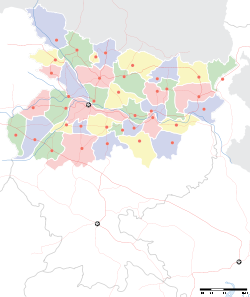
- Naugachia
-
Ngachia — city — Coordinates 25°24′N 87°06′E / 25.4°N 87.1°ECoordinates: 25°24′N 87°06′E / 25.4°N 87.1°E Country India State Bihar District(s) Bhagalpur Population 38,288 (2001[update]) Time zone IST (UTC+05:30) Area
• 25 metres (82 ft)
Naugachia (Hindi: नौगछिया) is a city and a notified area in Bhagalpur district in the Indian state of Bihar. It is a block and a division of the Bhagalpur district[1], and also a police district.
Contents
Geography
Naugachia is located at Click Here . It has an average elevation of 25 metres (82 feet). It is bordered on one side by the river Ganges and one by the river Koshi. It is famous for yellow maize, known as Kelanchal of Bihar. Due to the building of a ring dam, flooding is no longer a problem for Naugachia.
Demographics
As of 2001[update] India census[2], Naugachia had a population of 38,288. Males constitute 54% of the population and females 46%. Naugachia has an average literacy rate of 48%, lower than the national average of 59.5%: male literacy is 56%, and female literacy is 38%. In Naugachia, 19% of the population is under 6 years of age.
Administration
Naugachia Nagar Panchayat[1] is the governing body in the town.
Transport
The Naugachia railway station is managed by the East Central Railway. The railway station code is NNA.[3] The nearest airport is the Lok Nayak Jayaprakash Airport, Patna. Naugachia lies close the banks of Ganges river as well as kosi river. Vikramshila Setu, the second longest bridge across Ganges, connects Naugachia with Barari Ghat in Bhagalpur.National Highway-31 is also nearby.[4]
Villages
- Mahdattpur
- Thana Bihpur
- Bikrampur
- Sonvarsa
- Simra
- Nagarpada
- Punama Pratap Nagar
- Nagraha
- Dayalpur
- Rangra
- Kumedpur
- Murli.
- Madarauni.
- Baniya
- Baisi.
- Chandrakhara.
- Bhawanipur.
- Tetri
- Bhramarpur
- Khagra
- Mukundpur
- Maniamore
- Naya Tola
- Saidpur
- Ujani
- Pakra
- Borba
- Madwa
- Jairampur
- Birbanna
- Bari Makandpur
- Gosaingaon
- Bari Makandpur(maudha Tola)
- TulsiPur
- sahu parbatta
- Dhobiniya
- Milki
- Khairpur Kadwa
- Laxmipur
- Rasalpur
- SihKund
- Lokmanpur
- Pachgachia Bazar
References
- ^ "Bhagalpur". http://www.gloriousindia.com/places/br/bhagalpur.html. Retrieved 2007-05-12.
- ^ "Census of India 2001: Data from the 2001 Census, including cities, villages and towns (Provisional)". Census Commission of India. Archived from the original on 2004-06-16. http://web.archive.org/web/20040616075334/http://www.censusindia.net/results/town.php?stad=A&state5=999. Retrieved 2008-11-01.
- ^ "Naugachia Railway Station". http://www.india9.com/i9show/Naugachia-Railway-Station-65285.htm. Retrieved 2007-05-12.
- ^ "New Ganga Bridge a Boon". Development Digest Vol.4 1–31 July 2001 No.4. Research, Reference and Training Division, Ministry of Information and Broadcasting, Government of India. http://rrtd.nic.in/ddjuly2k1.htm. Retrieved 2007-05-12.
Cities and towns in Bhagalpur Division, Bihar, India Banka district Bhagalpur district See also Bhagalpur division topicsCities and towns in other Divisions Categories:- Cities and towns in Bhagalpur district
Wikimedia Foundation. 2010.


