National Route 9 (Vietnam)

National Route 9 (Vietnam)

National Route 9 (Vietnamese language: Quốc lộ 9 (or abbrv. QL9) or Đường 9) runs across Vietnam roughly in line with the 17th Parallel. The route includes two segments. The segment called National Route 9A begins at Dong Ha and ends at Lao Bảo on the Vietnam-Laos border and is entirely within Quang Tri Province. The 8 km-long segment called National Route 9B begins at Dong Ha and runs eastward to Cửa Việt Port.

Contents

Road layout

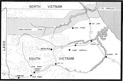
Route 9 runs through the following towns and cities of Quang Tri Province:

Specifications

  • Total length: 82 km
  • Road width: 10m
  • Road surface: paved with asphalt

History

Route Coloniale 9 or RC9 was constructed by the French in the early 20th century.

With the partition of Vietnam following the First Indochina War, Route 9 was the northernmost West-East road in South Vietnam and ran roughly parallel to the Vietnamese Demilitarized Zone.

Map of the Demilitarized Zone

In the early 1960s as the Vietnam War began to increase in intensity, the Army of the Republic of Vietnam (ARVN) and US Special Forces began to build a chain of bases south of the DMZ to interdict the flow of men and materiel from North Vietnam. These bases included:

Route 9 became a vital supply artery to these bases and the North Vietnamese Army (NVA) were frequently able to cut or ambush Route 9 during the "Border Battles" period from 1967 to 1969. Route 9 was the access road used in Operation Pegasus and Operation Lam Son 719.

In recent years with the implementation of Vietnam's Doi Moi reforms there has been an increase in cross-border trade with Laos and Route 9 has been progressively upgraded. With the completion of the Ho Chi Minh Highway, Route 9 has become an important link between the Ho Chi Minh Highway and Route 1.

References

  • Vietnam Road Map Book (Tập Bản đồ Giao thông Đường bộ Việt Nam) revision 2004 by Vietnam Map Publishing House.

Wikimedia Foundation. 2010.

Игры ⚽ Нужен реферат?

Look at other dictionaries:

  • National Route 7 (Vietnam) — National Route 7 in Vietnam may be: National Route 7A (Vietnam) National Route 7B (Vietnam) This disambiguation page lists articles associated with the same title. If an internal link led you here, you …   Wikipedia

  • National Route 8 (Vietnam) — Route 8 in Annamite Range. National Route 8 is a highway in Hà Tĩnh Province in North Central of Vietnam, which is managed and maintained by the central government. The route includes two segments. The 85.3 km long segment from Hồng Lĩnh Township …   Wikipedia

  • National Route 1A (Vietnam) — National Route 1A (Vietnamese language: Quốc lộ 1A (or abbrv. QL1A) or Đường 1 is the trans Vietnam highway. The route begins at km 0 at Huu Nghi Quan Border Gate (cửa khẩu Hữu Nghị Quan) near the Sino Vietnamese border.[1] The route ends at (km… …   Wikipedia

  • National Route 7A (Vietnam) — National Route 7A (Vietnamese: quốc lộ 7A) is a national highway in Vietnam which runs entirely in Nghệ An Province, North Central Vietnam. The 225 kilometer long route runs from Diễn Châu Town (Diễn Châu District) northwestward across Yên Thành …   Wikipedia

  • National Route 22 (Vietnam) — National Route 22 (Vietnamese: Quốc lộ 22) is a highway in southern Vietnam stretching from the northwestern outskirts of Ho Chi Minh City, the commercial centre of the country, towards the Cambodian border to the northwest. It is the main route… …   Wikipedia

  • National Route 91 (Vietnam) — National Route 91 (Vietnamese: Quốc lộ 91) is highway in the Mekong Delta region of Vietnam, stretching from Can Tho, the largest city in the delta, northwest toward the border town of Chau Doc, near Cambodia. The highway continues into Cambodia… …   Wikipedia

  • National Route 30 (Vietnam) — National Route 30 (Vietnamese: Quốc lộ 30) is a highway in the Mekong Delta region of Vietnam stretching from just north of Vinh Long, the capital of Vinh Long Province, northwest parallel to the Tien Giang River into Dong Thap Province before… …   Wikipedia

  • National Route 51 (Vietnam) — National Route 51 (Vietnamese: Quốc lộ 51) is a four lane highway starting from the city of Biên Hòa to Vung Tau in Dong Nam Bo, Vietnam, passing Bình, Long Thành, Bà Rịa town. This is the backbone route linking Ba Ria Vung Tau Province with Dong …   Wikipedia

  • National Route 13 (Vietnam) — National Route 13 (Vietnamese: Quốc lộ 13) is a highway in southern Vietnam stretching from the northeastern outskirts of Ho Chi Minh City, the commercial centre of the country, towards the border to Cambodia. The highway starts around Thu Duc on …   Wikipedia

  • National Road 22 (Vietnam) — National Road 22 ( vi. Quốc lộ 22) is a highway in southern Vietnam stretching from the northwestern outskirts of Ho Chi Minh City, the commercial centre of the country towards the Cambodian border to the northwest. It is the main route for trade …   Wikipedia

Share the article and excerpts

Direct link
Do a right-click on the link above
and select “Copy Link”