- National Register of Historic Places listings in Will County, Illinois
-
See also: List of Registered Historic Places in Illinois
Contents: List of Registered Historic Places in Will County, Illinois, USA:
-
- This National Park Service list is complete through NPS recent listings posted November 10, 2011.[1]
Contents
Will County
Landmark name Image Date listed Location City or Town Summary 1 Alternate Route 66, Wilmington to Joliet 
May 5, 2006 Illinois Route 53 between Wilmington and Joliet
41°24′16″N 88°6′27″W / 41.40444°N 88.1075°WJoliet
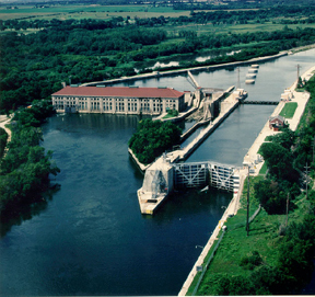
WilmingtonThis is the section of former U.S. Route 66 that traveled from Wilmington to Joliet. The road mostly traverses agricultural land, but does pass the former Joliet Army Ammunition Plant. Most of this 15.9-mile (25.6 km) stretch has been re-designated Illinois Route 53. One bridge, one overpass, and Four concrete box culverts along the road are also included in the listing. 2 Brandon Road Lock and Dam Historic District March 10, 2004 1100 Brandon Road
41°30′16.9″N 88°6′20.4″W / 41.504694°N 88.105667°WJoliet The Brandon Road Lock and Dam is one of eight locks and dams used to control water levels of the Illinois Waterway. The waterway connects the Chicago River to the Mississippi River. 3 Briscoe Mounds 
December 22, 1978 Front St. along the Des Plaines River[2] Channahon The mounds are an archeological site located along the north side of the Des Plaines River. Surveys and excavations from 1938 to 1964 revealed Mississippian pottery and bodies dating from 1200–1500 AD. 4 Christ Episcopal Church 
August 12, 1982 75 West Van Buren Street
41°31′33″N 88°5′3″W / 41.52583°N 88.08417°WJoliet The church was built in 1885 to serve the Episcopalian religious congregation. Designed by F. S. Allen, the congregation met in the church until 2004. It was destroyed in a 2006 fire.[3] 5 Downtown Peotone Historic District November 16, 2005 Roughly North First Street and both sides of North Second Street, roughly bounded by the alley south of Main and north by North Street
41°20′3″N 87°47′29″W / 41.33417°N 87.79139°WPeotone The Illinois Central Railroad opened in 1856 with a station in eastern Will County. The surrounding area became known as Peotone and featured a lively commercial district along the tracks. This district later expanded in response to growing use of automobiles. 6 Eagle Hotel 
February 16, 1994 100–104 Water Street
41°18′28″N 88°8′51″W / 41.30778°N 88.1475°WWilmington Eagle Hotel opened in the late 1830s to accommodate farmers traveling to Wilmington to use the local grist mill. The Chicago and Alton Railroad and U.S. Route 66 were later constructed near the hotel, providing further commerce. The interior was badly damaged in a 1990 fire. 7 Fitzpatrick House 
February 9, 1984 Illinois Route 53
41°36′2″N 88°4′15″W / 41.60056°N 88.07083°WLockport 8 Flanders House 
November 14, 1991 405 West Main Street
41°36′45″N 88°12′10″W / 41.6125°N 88.20278°WPlainfield 9 Ron George Round Barn 
December 7, 1982 Northeast of Romeoville off of U.S. Route 66
41°39′28″N 88°9′52″W / 41.65778°N 88.16444°WBolingbrook Relocated in 1998 to Essington Road.[4] 10 John Heck House 
August 16, 1994 1225 South Hamilton Street
41°35′7″N 88°3′29″W / 41.58528°N 88.05806°WLockport 11 Jacob H. Henry House 
May 14, 1979 20 South Eastern Avenue
41°31′23″N 88°4′35″W / 41.52306°N 88.07639°WJoliet 12 Illinois and Michigan Canal 
October 15, 1966 7 miles (11 km) southwest of Joliet on U.S. Route 6, in Channahon State Park
41°34′11″N 88°4′11″W / 41.56972°N 88.06972°WJoliet 13 Joliet YMCA 
February 9, 2006 215 North Ottawa Street
41°31′50″N 88°5′1″W / 41.53056°N 88.08361°WJoliet 14 Joliet East Side Historic District August 15, 1980 Roughly bounded by Washington and Union Streets, 4th and Eastern Avenues
41°31′8″N 88°4′28″W / 41.51889°N 88.07444°WJoliet 15 Joliet Municipal Airport December 10, 1980 4000 West Jefferson Street
41°31′24″N 88°10′46″W / 41.52333°N 88.17944°WJoliet 16 Joliet Steel Works 
February 28, 1991 927 Collins Street
41°32′28″N 88°4′30″W / 41.54111°N 88.075°WJoliet 17 Joliet Township High School 
August 12, 1982 201 East Jefferson Street
41°31′32″N 88°4′28″W / 41.52556°N 88.07444°WJoliet 18 Louis Joliet Hotel 
February 9, 1990 22 East Clinton Street
41°31′36″N 88°4′48″W / 41.52667°N 88.08°WJoliet 19 Lockport Historic District 
May 12, 1975 Area between 7th and 11th Streets and Canal and Washington Streets
41°35′22″N 88°3′25″W / 41.58944°N 88.05694°WLockport 20 Lockport Lock, Dam and Power House Historic District 
March 10, 2004 2502 Channel Drive
41°34′10″N 88°4′44″W / 41.56944°N 88.07889°WLockport 21 McGovney–Yunker Farmstead 
May 31, 2006 10824 LaPorte Road
41°31′36″N 87°52′53″W / 41.52667°N 87.88139°WMokena 22 Robert Milne House 
December 17, 1979 535 East 7th Street
41°35′22″N 88°2′57″W / 41.58944°N 88.04917°WLockport 23 Ninth Street Seven Arch Stone Bridge August 20, 2004 Ninth Street spanning Deep Run Creek
41°35′36″N 88°3′53″W / 41.59333°N 88.06472°WLockport Destroyed in a 2011 storm.[5] 24 Peotone Mill 
March 19, 1982 433 West Corning Avenue
41°19′56″N 87°47′53″W / 41.33222°N 87.79806°WPeotone 25 Plainfield Halfway House 
September 29, 1980 503 Main Street
41°36′41″N 88°12′15″W / 41.61139°N 88.20417°WPlainfield 26 Rubens Rialto Square Theater 
July 24, 1978 102 North Chicago Street
41°31′34″N 88°4′53″W / 41.52611°N 88.08139°WJoliet 27 Hiram B. Scutt Mansion 
February 5, 2003 206 N Broadway
41°31′37″N 88°5′18″W / 41.52694°N 88.08833°WJoliet 28 Small–Towle House May 12, 2004 515 County Road
41°18′39″N 88°8′31″W / 41.31083°N 88.14194°WWilmington 29 Standard Oil Gasoline Station 
November 13, 1984 600 West Lockport Street
41°36′29″N 88°12′20″W / 41.60806°N 88.20556°WPlainfield 30 Stone Manor 
November 26, 1980 Southeast of Lockport
41°34′23″N 87°56′10″W / 41.57306°N 87.93611°WHomer Glen 31 U.S. Post Office 
August 20, 1981 150 North Scott Street
41°31′39″N 88°4′49″W / 41.5275°N 88.08028°WJoliet 32 Union Station 
August 1, 1978 50 East Jefferson Street
41°31′28″N 88°4′47″W / 41.52444°N 88.07972°WJoliet 33 Upper Bluff Historic District 
June 5, 1991 Roughly bounded by Taylor, Center and Campbell Streets and Raynor Avenue
41°31′45″N 88°5′47″W / 41.52917°N 88.09639°WJoliet 34 Will County Historical Society Headquarters 
May 17, 1972 803 South State Street
41°35′21″N 88°3′17″W / 41.58917°N 88.05472°WLockport See also
- List of National Historic Landmarks in Illinois
- National Register of Historic Places listings in Illinois
References
- ^ "National Register of Historic Places: Weekly List Actions". National Park Service, United States Department of the Interior. Retrieved on November 10, 2011.
- ^ http://www.channahon.org/good-living/parks-recreation.htm
- ^ http://articles.chicagotribune.com/2006-10-10/news/0610100111_1_structure-second-oldest-church-lovely-church
- ^ "Bolingbrook to Save Round Barn". Joliet Herald-News. April 23, 1998.
- ^ http://heraldnews.suntimes.com/news/7791760-418/historic-lockport-bridge-limestone-to-be-used-for-fundraising.html
External links
- Will County Listings at nationalregisterofhistoricplaces.com
U.S. National Register of Historic Places Topics Lists by states Alabama • Alaska • Arizona • Arkansas • California • Colorado • Connecticut • Delaware • Florida • Georgia • Hawaii • Idaho • Illinois • Indiana • Iowa • Kansas • Kentucky • Louisiana • Maine • Maryland • Massachusetts • Michigan • Minnesota • Mississippi • Missouri • Montana • Nebraska • Nevada • New Hampshire • New Jersey • New Mexico • New York • North Carolina • North Dakota • Ohio • Oklahoma • Oregon • Pennsylvania • Rhode Island • South Carolina • South Dakota • Tennessee • Texas • Utah • Vermont • Virginia • Washington • West Virginia • Wisconsin • WyomingLists by territories Lists by associated states Other Municipalities and communities of Will County, Illinois Cities Aurora‡ | Braidwood | Crest Hill | Joliet‡ | Lockport | Naperville‡ | Wilmington

Villages Beecher | Bolingbrook‡ | Channahon‡ | Coal City‡ | Crete | Diamond‡ | Elwood | Frankfort‡ | Godley‡ | Homer Glen | Lemont‡ | Manhattan | Matteson‡ | Minooka‡ | Mokena | Monee | New Lenox | Orland Park‡ | Park Forest‡ | Peotone | Plainfield‡ | Rockdale | Romeoville | Sauk Village‡ | Shorewood | Steger‡ | Symerton | Tinley Park‡ | University Park‡ | Woodridge‡
CDPs Townships Unincorporated
communitiesGhost town Footnotes ‡This populated place also has portions in an adjacent county or counties
Categories:- Will County, Illinois
- National Register of Historic Places in Will County, Illinois
- National Register of Historic Places in Illinois by county
-


Wikimedia Foundation. 2010.