- National Register of Historic Places listings in Sacramento County, California
-
This list includes properties and districts listed on the National Register of Historic Places in Sacramento County, California. [1]
-
- This National Park Service list is complete through NPS recent listings posted November 10, 2011.[2]
 Big Four House, after move to Old Sacramento area
The table below omits Big Four House which is a National Historic Landmark designated in 1961. It should have been automatically listed on the National Register in 1966, but does not appear in the National Register's NRIS database. Its NRHP listing status is thus unclear.[3]
[4] Landmark name[5] Image Date listed Location City or Town Summary 1 Alkali Flat Central Historic District July 26, 1984 Roughly E and F Sts. between 9th and 12th Sts.
38°35′4″N 121°29′23″W / 38.58444°N 121.48972°WSacramento 2 Alkali Flat North Historic District April 19, 1984 D and 11th Sts.
38°35′12″N 121°29′16″W / 38.58667°N 121.48778°WSacramento 3 Alkali Flat West Historic District July 26, 1984 E, F, and 8th Sts.
38°35′9″N 121°29′35″W / 38.58583°N 121.49306°WSacramento 4 Alta Mesa Farm Bureau Hall January 7, 1987 10195 Alta Mesa Rd.
38°23′14″N 121°13′20″W / 38.38722°N 121.22222°WWilton Burned down in 1987, one year after its inception into the NRHP. [6] 5 American River Grange Hall No. 172 October 10, 1996 2720 Kilgora Rd.
38°36′3″N 121°16′28″W / 38.60083°N 121.27444°WRancho Cordova 6 Blue Anchor Building February 3, 1983 1400 10th St.
38°34′33″N 121°29′42″W / 38.57583°N 121.495°WSacramento 7 Boulevard Park October 6, 2011 Roughly bounded by B and H Streets, 20th Street, 22nd Street and 23rd Street
38°34′53″N 121°28′32″W / 38.58139°N 121.47556°WSacramento Historic Residential Suburbs in the United States, 1830-1960 MPS 8 Brewster Building 
August 16, 2000 201 Fourth St.
38°15′13″N 121°21′42″W / 38.25361°N 121.36167°WGalt 9 Brewster House 
June 23, 1978 206 5th St.
38°15′12″N 121°18′14″W / 38.25333°N 121.30389°WGalt 10 Brighton School April 3, 1981 3312 Bradshaw Rd.
38°33′44″N 121°20′9″W / 38.56222°N 121.33583°WSacramento 11 John Stanford Brown House July 28, 2004 13950 CA 160
38°14′53″N 121°30′41″W / 38.24806°N 121.51139°WWalnut Grove 12 California Governor's Mansion 
November 10, 1970 16th and H Sts.
38°34′49″N 121°29′1″W / 38.58028°N 121.48361°WSacramento 13 California State Capitol 
April 3, 1973 Between 10th and 16th and L and N Sts.
38°34′34″N 121°29′26″W / 38.57611°N 121.49056°WSacramento 14 Calpak Plant No. 11 May 17, 1984 1721 C St.
38°35′3″N 121°28′47″W / 38.58417°N 121.47972°WSacramento 15 Capitol Extension District May 24, 1984 Capitol Mall
38°34′37″N 121°29′46″W / 38.57694°N 121.49611°WSacramento 16 J.C. Carly House March 22, 2006 2761 Montgomery Way
38°32′56″N 121°28′33″W / 38.54889°N 121.47583°WSacramento 17 Chung Wah Cemetery August 21, 1995 Mormon St. vicinity, near Lake Natoma
38°40′13″N 121°11′43″W / 38.67028°N 121.19528°WFolsom 18 Cohn House January 21, 1982 305 Scott St.
38°40′43″N 121°10′26″W / 38.67861°N 121.17389°WFolsom 19 Coolot Company Building 
September 20, 1978 812 J St.
38°34′51″N 121°29′41″W / 38.58083°N 121.49472°WSacramento No longer standing. Originally constructed in 1861 by Leland Stanford. [6] 20 Cranston-Geary House January 23, 1998 2101 G St.
38°34′47″N 121°28′32″W / 38.57972°N 121.47556°WSacramento 21 E. B. Crocker Art Gallery 
May 6, 1971 216 O St.
38°34′37″N 121°30′18″W / 38.57694°N 121.505°WSacramento 22 Delta King 
March 31, 1978 1000 Front St.
38°34′58″N 121°30′25″W / 38.58278°N 121.50694°WSacramento Located in Rio Vista when listed on the National Register; moved to Old Sacramento in 1984 and converted to a hotel, restaurant and theater[7] 23 Delta Meadows Site 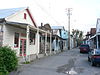
November 5, 1971 Address Restricted Locke 24 Dunlap's Dining Room April 2, 1992 4322 Fourth Ave.
38°32′52″N 121°27′18″W / 38.54778°N 121.455°WSacramento 25 Eastern Star Hall January 7, 1993 2719 K St.
38°34′21″N 121°28′22″W / 38.5725°N 121.47278°WSacramento 26 William Ehrhardt House July 10, 2003 Dartmoor Way and Percheron Dr.
38°24′11″N 121°26′54″W / 38.40306°N 121.44833°WElk Grove 27 Elk Grove Historic District March 1, 1988 8986-9097 Elk Grove Blvd. also School, Gage and Grove Sts.
38°24′33″N 121°21′49″W / 38.40917°N 121.36361°WElk Grove 28 Fair Oaks Bridge September 25, 2006 Crosses America R. at Bridge St. to American R Pkwy,N of Upper Sunrise Dr. in Gold R
38°38′17″N 121°15′54″W / 38.63806°N 121.265°WFair Oaks 29 Fire Station No. 6 April 25, 1991 3414 4th Ave.
38°33′2″N 121°28′7″W / 38.55056°N 121.46861°WSacramento 30 Firehouse No. 3 October 29, 1991 1215 19th St.
38°34′28″N 121°28′52″W / 38.57444°N 121.48111°WSacramento 31 Folsom Depot February 19, 1982 200 Wool St.
38°40′45″N 121°10′47″W / 38.67917°N 121.17972°WFolsom 32 Folsom Powerhouse 
October 2, 1973 Off Folsom Blvd. in Folsom Lake State Recreation Area
38°40′50″N 121°10′32″W / 38.68056°N 121.17556°WFolsom 33 Mary Haley Galarneaux House February 12, 2001 922-924 T. St.
38°34′15″N 121°29′56″W / 38.57083°N 121.49889°WSacramento 34 Goethe House February 19, 1982 3731 T St.
38°33′33″N 121°27′34″W / 38.55917°N 121.45944°WSacramento 35 John T. Greene House April 15, 1982 3200 H St.
38°34′31″N 121°27′44″W / 38.57528°N 121.46222°WSacramento 36 Heilbron House December 12, 1976 704 O St.
38°34′34″N 121°29′54″W / 38.57611°N 121.49833°WSacramento 37 Hotel Regis October 29, 1982 1024-1030 K St
38°34′44″N 121°29′30″W / 38.57889°N 121.49167°WSacramento 38 Hotel Senator May 30, 1979 1121 L St.
38°34′40″N 121°29′28″W / 38.57778°N 121.49111°WSacramento 39 Edward P. Howe, Jr., House February 19, 1982 2215 21st St.
38°33′46″N 121°28′59″W / 38.56278°N 121.48306°WSacramento 40 Hubbard-Upson House December 2, 1977 1010 F St.
38°35′4″N 121°29′24″W / 38.58444°N 121.49°WSacramento 41 I Street Bridge 
April 22, 1982 CA 16
38°34′39″N 121°30′18″W / 38.5775°N 121.505°WSacramento 42 Imperial Theatre October 29, 1982 Market St.
38°14′29″N 121°30′46″W / 38.24139°N 121.51278°WWalnut Grove 43 Indian Stone Corral April 16, 1975 Address Restricted Orangevale 44 Isleton Chinese and Japanese Commercial Districts March 14, 1991 Bounded by River Rd. and Union, E and H Sts.
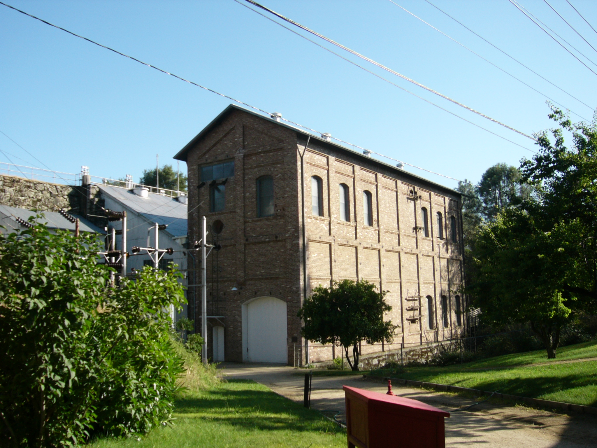
38°9′45″N 121°36′18″W / 38.1625°N 121.605°WIsleton 45 J Street Wreck May 16, 1991 At the foot of J St., in the Sacramento R.
38°35′2″N 121°30′19″W / 38.58389°N 121.50528°WSacramento The remains of a brig used as a warehouse off J Street which sank in 1855. [6] 46 Joe Mound October 14, 1971 Address Restricted Sacramento An Indian village site of the Maidu near present day Discovery Park. No marker on the site.[6] 47 J. Neely Johnson House 
September 13, 1976 1029 F St.
38°35′5″N 121°29′22″W / 38.58472°N 121.48944°WSacramento 48 Theodore Judah School July 25, 1997 3919 McKinley Blvd.
38°34′39″N 121°27′42″W / 38.5775°N 121.46167°WSacramento 49 Kuchler Row June 25, 1982 608-614 10th St.
38°35′3″N 121°29′27″W / 38.58417°N 121.49083°WSacramento 50 Charles Lais House February 28, 1985 1301 H St.
38°34′54″N 121°29′13″W / 38.58167°N 121.48694°WSacramento 51 Libby McNeil and Libby Fruit and Vegetable Cannery March 2, 1982 1724 Stockton Blvd.
38°33′52″N 121°27′59″W / 38.56444°N 121.46639°WSacramento 52 Locke Historic District May 6, 1971 Bounded on the W by the Sacramento River, on the N by Locke Rd., on the E by Alley St., and on the S by Levee St.
38°15′3″N 121°30′26″W / 38.25083°N 121.50722°WLocke 53 C. K. McClatchy Senior High School 
November 2, 2001 3066 Freeport Blvd.
38°33′4″N 121°29′33″W / 38.55111°N 121.4925°WSacramento 54 Merchants National Bank of Sacramento February 16, 1996 1015 7th St.
38°34′52″N 121°29′47″W / 38.58111°N 121.49639°WSacramento 55 Merrium Apartments September 13, 1990 1017 14th St.
38°34′41″N 121°29′12″W / 38.57806°N 121.48667°WSacramento Demolished in the 1990s for expansion of the Sacramento Convention Center. [6] 56 Mesick House 
January 21, 1982 517 8th St.
38°35′10″N 121°29′34″W / 38.58611°N 121.49278°WSacramento 57 Nisenan Village Site March 21, 1978 Address Restricted Carmichael 58 Old Sacramento Historic District 
October 15, 1966 Jcts. of U.S. 40, 50, 99, and CA 16 and 24
38°34′58″N 121°30′12″W / 38.58278°N 121.50333°WSacramento 59 Old Tavern September 15, 1983 2801 Capitol Ave.
38°34′15″N 121°28′9″W / 38.57083°N 121.46917°WSacramento 60 PG&E Powerhouse September 23, 2010 400 Jibboom St.
38°35′42″N 121°30′18″W / 38.595°N 121.505°WSacramento 61 Pony Express Terminal 
October 15, 1966 1006 2nd St.
38°34′59″N 121°30′11″W / 38.58306°N 121.50306°WSacramento Also known as B. F. Hastings Bank Building 62 Rosebud Ranch December 31, 1979 N of Hood
38°23′8″N 121°30′46″W / 38.38556°N 121.51278°WHood 63 Ruhstaller Building January 21, 1982 900 J St.
38°34′50″N 121°29′38″W / 38.58056°N 121.49389°WSacramento 64 Runyon House October 27, 2000 12865 River Rd.
38°17′20″N 121°33′20″W / 38.28889°N 121.55556°WCourtland 65 Sacramento Air Depot Historic District January 21, 1992 McClellan Air Force Base
38°39′33″N 121°23′13″W / 38.65917°N 121.38694°WNorth Highlands 66 Sacramento Bank Building January 21, 1982 3418 Broadway
38°33′7″N 121°28′5″W / 38.55194°N 121.46806°WSacramento 67 Sacramento City Library July 30, 1992 828 I St.
38°34′54″N 121°29′37″W / 38.58167°N 121.49361°WSacramento 68 Sacramento Hall of Justice September 24, 1999 813 6th St.
38°35′1″N 121°29′6″W / 38.58361°N 121.485°WSacramento 69 Sacramento Junior College Annex and Extensions 
August 22, 1994 3835 Freeport Blvd.
38°32′28″N 121°29′17″W / 38.54111°N 121.48806°WSacramento 70 Sacramento Masonic Temple 
May 17, 2001 1131 J St.
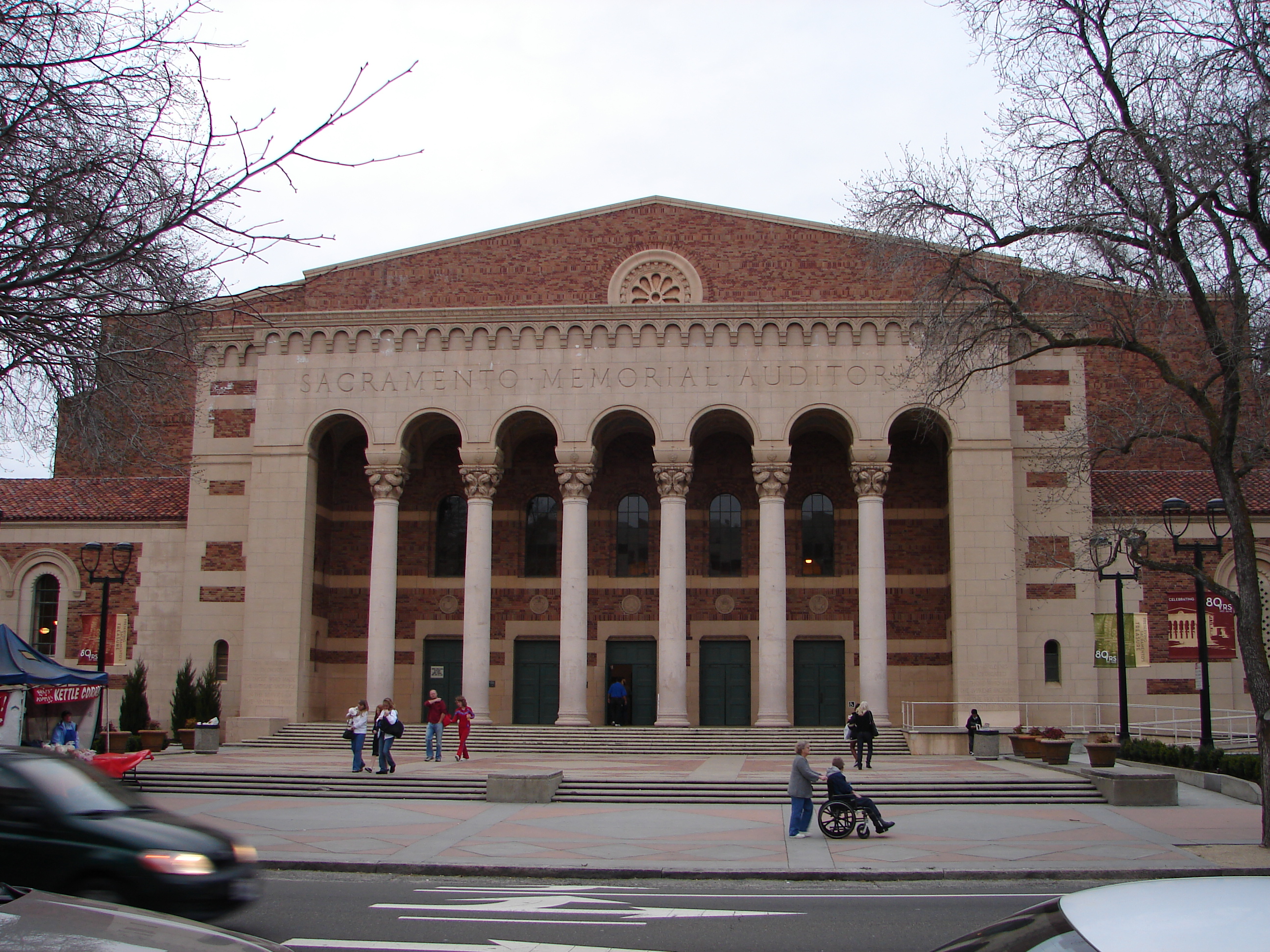
38°34′55″N 121°29′27″W / 38.58194°N 121.49083°WSacramento 71 Sacramento Memorial Auditorium 
March 29, 1978 16th and J Sts.
38°34′44″N 121°29′5″W / 38.57889°N 121.48472°WSacramento 72 Slocum House January 31, 1979 7992 California Ave.
38°38′29″N 121°16′5″W / 38.64139°N 121.26806°WFair Oaks 73 Southern Pacific Railroad Company's Sacramento Depot 
April 21, 1975 5th and I Sts.
38°35′3″N 121°30′0″W / 38.58417°N 121.5°WSacramento 74 SMUD Headquarters Building January 4, 2010 6301 S. St.
38°33′11.24″N 121°25′58.3″W / 38.5531222°N 121.432861°WSacramento 75 Southern Pacific Railroad Section Superintendent House June 13, 2008 815 Oakdale St.
38°40′10.7″N 121°10′55.3″W / 38.669639°N 121.182028°WFolsom 76 Stanford-Lathrop House 
December 9, 1971 800 N St.
38°34′35″N 121°29′50″W / 38.57639°N 121.49722°WSacramento 77 Sutter's Fort 
October 15, 1966 2701 L St.
38°34′20″N 121°28′12″W / 38.57222°N 121.47°WSacramento 78 Tower Bridge 
June 24, 1982 CA 275 across Sacramento River
38°34′18″N 121°30′25″W / 38.57167°N 121.50694°WSacramento 79 Travelers' Hotel 
October 19, 1978 428 J St.
38°34′54″N 121°29′58″W / 38.58167°N 121.49944°WSacramento 80 U.S. Post Office, Courthouse and Federal Building 
January 25, 1980 801 I St.
38°34′57″N 121°29′37″W / 38.5825°N 121.49361°WSacramento 81 Van Voorhies House November 17, 1977 925 G St.
38°35′3″N 121°29′29″W / 38.58417°N 121.49139°WSacramento 82 Anton Wagner Duplex November 10, 1980 701 E St.
38°35′13″N 121°29′35″W / 38.58694°N 121.49306°WSacramento 83 Walnut Grove Chinese-American Historic District March 22, 1990 Bounded by C, Tyler, and Bridge Sts., and River Rd.
38°14′32″N 121°30′46″W / 38.24222°N 121.51278°WWalnut Grove 84 Walnut Grove Commercial/Residential Historic District April 12, 1990 Browns Alley and River Rd.
38°14′21″N 121°30′54″W / 38.23917°N 121.515°WWalnut Grove 85 Walnut Grove Gakuen Hall June 17, 1980 Pine and C Sts.
38°14′31″N 121°30′33″W / 38.24194°N 121.50917°WWalnut Grove 86 Walnut Grove Japanese-American Historic District March 22, 1990 Bounded by Winnie St., Tyler St., C St., and River Rd.
38°14′36″N 121°30′44″W / 38.24333°N 121.51222°WWalnut Grove 87 Westminster Presbyterian Church May 22, 2003 1300 N St.
38°34′35″N 121°29′27″W / 38.57639°N 121.49083°WSacramento 88 Julius Wetzlar House March 31, 1983 1021 H St.
38°34′58″N 121°29′27″W / 38.58278°N 121.49083°WSacramento 89 Winters House January 25, 1999 2324 and 2326 H St.
38°34′39″N 121°28′23″W / 38.5775°N 121.47306°WSacramento 90 Edwin Witter Ranch March 14, 1991 3480 Witter Way
38°37′54″N 121°32′5″W / 38.63167°N 121.53472°WSacramento 91 Woodlake Site May 6, 1971 Address Restricted Sacramento See also
- National Register of Historic Places listings in California
- List of National Historic Landmarks in California
References
- ^ The latitude and longitude information provided in this table was derived originally from the National Register Information System, which has been found to be fairly accurate for about 99% of listings. For about 1% of NRIS original coordinates, experience has shown that one or both coordinates are typos or otherwise extremely far off; some corrections may have been made. A more subtle problem causes many locations to be off by up to 150 yards, depending on location in the country: most NRIS coordinates were derived from tracing out latitude and longitudes off of USGS topographical quadrant maps created under the North American Datum of 1927, which differs from the current, highly accurate WGS84 GPS system used by Google maps. Chicago is about right, but NRIS longitudes in Washington are higher by about 4.5 seconds, and are lower by about 2.0 seconds in Maine. Latitudes differ by about 1.0 second in Florida. Some locations in this table may have been corrected to current GPS standards.
- ^ "National Register of Historic Places: Weekly List Actions". National Park Service, United States Department of the Interior. Retrieved on November 10, 2011.
- ^ Correspondence with National Register in progress.
- ^ Numbers represent an ordering by significant words. Various colorings, defined here, differentiate National Historic Landmark sites and National Register of Historic Places Districts from other NRHP buildings, structures, sites or objects.
- ^ "National Register Information System". National Register of Historic Places. National Park Service. 2008-04-24. http://nrhp.focus.nps.gov/natreg/docs/All_Data.html.
- ^ a b c d e McManis, Sam (5 November 2011). "Sacramento sites on Historic Register sometimes elusive". Sacramento Bee. http://www.sacbee.com/2011/11/05/4029224/sacramento-sites-on-historic-register.html.
- ^ "The Story of the Delta King". Sacramento, California. http://www.deltaking.com/index.php?option=com_content&view=article&id=9. Retrieved February 13, 2011.
U.S. National Register of Historic Places Topics Lists by states Alabama • Alaska • Arizona • Arkansas • California • Colorado • Connecticut • Delaware • Florida • Georgia • Hawaii • Idaho • Illinois • Indiana • Iowa • Kansas • Kentucky • Louisiana • Maine • Maryland • Massachusetts • Michigan • Minnesota • Mississippi • Missouri • Montana • Nebraska • Nevada • New Hampshire • New Jersey • New Mexico • New York • North Carolina • North Dakota • Ohio • Oklahoma • Oregon • Pennsylvania • Rhode Island • South Carolina • South Dakota • Tennessee • Texas • Utah • Vermont • Virginia • Washington • West Virginia • Wisconsin • WyomingLists by territories Lists by associated states Other Municipalities and communities of Sacramento County, California Cities Citrus Heights | Elk Grove | Folsom | Galt | Isleton | Rancho Cordova | Sacramento

CDPs Antelope | Arden-Arcade | Carmichael | Clay | Courtland | Elverta | Fair Oaks | Florin | Foothill Farms | Franklin | Freeport | Fruitridge Pocket | Gold River | Herald | Hood | La Riviera | Lemon Hill | Mather | McClellan Park | North Highlands | Orangevale | Parkway | Rancho Murieta | Rio Linda | Rosemont | Vineyard | Walnut Grove | Wilton
Unincorporated
communitiesLocke | Paintersville | Parkway-South Sacramento | Ryde | Sloughhouse
Ghost towns Mormon Island | Sutterville
Categories:- Sacramento County, California
- Geography of Sacramento County, California
- National Register of Historic Places in California by county
- Lists of National Register of Historic Places in California
-


Wikimedia Foundation. 2010.