- National Register of Historic Places listings in Portsmouth, Virginia
-
This list includes properties and districts listed on the National Register of Historic Places in the independent city of Portsmouth, Virginia. Click the "Map of all coordinates" link to the right to view a Google map of all properties and districts with latitude and longitude coordinates in the table below.[1]
-
- This National Park Service list is complete through NPS recent listings posted November 10, 2011.[2]
[3] Landmark name[4] Image Date listed Location City or Town Summary 1 Cedar Grove Cemetery October 15, 1992 301 Fort Ln.
36°50′20″N 76°18′29″W / 36.83889°N 76.30806°WPortsmouth 2 The Circle March 8, 2006 3010 High St.
36°50′12″N 76°20′19″W / 36.83667°N 76.33861°WPortsmouth 3 Commodore Theatre February 27, 1997 421 High St.
36°50′5″N 76°18′8″W / 36.83472°N 76.30222°WPortsmouth 4 Confederate Monument September 4, 1997 Jct. of High and Court Sts.
36°50′6″N 76°18′4″W / 36.835°N 76.30111°WPortsmouth 5 Craddock Historic District June 20, 1974 Bounded by Paradise Creek, Victory Blvd., and George Washington Hwy.
36°48′7″N 76°19′4″W / 36.80194°N 76.31778°WPortsmouth 6 Downtown Portsmouth Historic District January 16, 2004 Roughly bounded by I-264, Middle St., Primrose St. and Queen St.
36°50′9″N 76°18′19″W / 36.83583°N 76.30528°WPortsmouth 7 Drydock No. 1 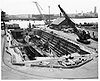
February 26, 1970 Norfolk Naval Shipyard
36°49′14″N 76°17′35″W / 36.82056°N 76.29306°WPortsmouth 8 Fort Nelson Chapter of the Daughters of the American Revolution Chapter House August 8, 2007 506 Westmoreland Ave.
36°49′59″N 76°21′50″W / 36.83306°N 76.36389°WPortsmouth 9 LIGHTSHIP No. 101, PORTSMOUTH 
May 5, 1989 London Slip, Elizabeth River
36°50′19″N 76°17′55″W / 36.83861°N 76.29861°WPortsmouth 10 Monumental Methodist Church January 15, 2004 450 Dinwiddie St.
36°50′9″N 76°18′10″W / 36.83583°N 76.30278°WPortsmouth 11 Park View Historic District October 4, 1984 Roughly bounded by Elm and Parkview Aves., Fort Lane, Blair, and Harrell Sts.
36°50′31″N 76°18′40″W / 36.84194°N 76.31111°WPortsmouth 12 Port Norfolk Historic District September 30, 1983 Roughly bounded by Bayview Blvd., Chatauqua Ave., Hartford St., Douglas Ave. and Hull Creek
36°50′54″N 76°20′14″W / 36.84833°N 76.33722°WPortsmouth 13 Portsmouth Community Library August 12, 2010 904 Elm St.
36°49′54″N 76°18′46″W / 36.83167°N 76.31278°WPortsmouth 14 Portsmouth Courthouse April 29, 1970 NE corner of Court and High Sts.
36°50′7″N 76°18′6″W / 36.83528°N 76.30167°WPortsmouth 15 Portsmouth Naval Hospital 
April 13, 1972 On Hospital Point at Washington and Crawford Sts.
36°50′51″N 76°18′17″W / 36.8475°N 76.30472°WPortsmouth 16 Portsmouth Olde Towne Historic District September 8, 1970 Bounded by Crawford Pkwy., London St., the Elizabeth River, and extending 0.1 mi. W of Washington St.
36°50′20″N 76°18′7″W / 36.83889°N 76.30194°WPortsmouth Boundary increase (listed October 6, 1983): Green and Queen Sts. 17 Pythian Castle 
October 30, 1980 610-612 Court St.
36°50′1″N 76°18′5″W / 36.83361°N 76.30139°WPortsmouth 18 Quarters A, B, and C, Norfolk Naval Shipyard December 19, 1974 Norfolk Naval Shipyard
36°49′35″N 76°17′51″W / 36.82639°N 76.2975°WPortsmouth 19 Seaboard Coastline Building October 10, 1985 1 High St.
36°50′5″N 76°17′49″W / 36.83472°N 76.29694°WPortsmouth 20 Shea Terrace Elementary School September 14, 2002 253 Constitution Ave.
36°50′31″N 76°19′28″W / 36.84194°N 76.32444°WPortsmouth 21 St. Paul's Catholic Church June 6, 2002 518 High St.
36°50′15″N 76°18′13″W / 36.8375°N 76.30361°WPortsmouth 22 Trinity Episcopal Church May 14, 1973 High and Court Sts.
36°50′5″N 76°18′5″W / 36.83472°N 76.30139°WPortsmouth 23 Truxtun Historic District September 16, 1982 Portsmouth and Deep Creek Blvds., Manly, Dahlin, Hobson, Dewey and Bagley Sts.
36°48′59″N 76°19′48″W / 36.81639°N 76.33°WPortsmouth See also
- National Register of Historic Places listings in Virginia
- List of National Historic Landmarks in Virginia
References
- ^ The latitude and longitude information provided in this table was derived originally from the National Register Information System, which has been found to be fairly accurate for about 99% of listings. For about 1% of NRIS original coordinates, experience has shown that one or both coordinates are typos or otherwise extremely far off; some corrections may have been made. A more subtle problem causes many locations to be off by up to 150 yards, depending on location in the country: most NRIS coordinates were derived from tracing out latitude and longitudes off of USGS topographical quadrant maps created under North American Datum of 1927, which differs from the current, highly accurate GPS system used by Google maps. Chicago is about right, but NRIS longitudes in Washington are higher by about 4.5 seconds, and are lower by about 2.0 seconds in Maine. Latitudes differ by about 1.0 second in Florida. Some locations in this table may have been corrected to current GPS standards.
- ^ "National Register of Historic Places: Weekly List Actions". National Park Service, United States Department of the Interior. Retrieved on November 10, 2011.
- ^ Numbers represent an ordering by significant words. Various colorings, defined here, differentiate National Historic Landmark sites and National Register of Historic Places Districts from other NRHP buildings, structures, sites or objects.
- ^ "National Register Information System". National Register of Historic Places. National Park Service. 2008-04-24. http://nrhp.focus.nps.gov/natreg/docs/All_Data.html.
U.S. National Register of Historic Places Topics Lists by states Alabama • Alaska • Arizona • Arkansas • California • Colorado • Connecticut • Delaware • Florida • Georgia • Hawaii • Idaho • Illinois • Indiana • Iowa • Kansas • Kentucky • Louisiana • Maine • Maryland • Massachusetts • Michigan • Minnesota • Mississippi • Missouri • Montana • Nebraska • Nevada • New Hampshire • New Jersey • New Mexico • New York • North Carolina • North Dakota • Ohio • Oklahoma • Oregon • Pennsylvania • Rhode Island • South Carolina • South Dakota • Tennessee • Texas • Utah • Vermont • Virginia • Washington • West Virginia • Wisconsin • WyomingLists by territories Lists by associated states Other  Category:National Register of Historic Places •
  Portal:National Register of Historic PlacesCategories:
- Portsmouth, Virginia
- National Register of Historic Places in Virginia
- Virginia-related lists
-


Wikimedia Foundation. 2010.