- National Register of Historic Places listings in Platte County, Wyoming
-
 Location of Platte County in Wyoming
This is a list of the National Register of Historic Places listings in Platte County, Wyoming.
It is intended to be a complete list of the properties and districts on the National Register of Historic Places in Platte County, Wyoming, United States. The locations of National Register properties and districts for which the latitude and longitude coordinates are included below, may be seen in a Google map.[1]
There are 12 properties and districts listed on the National Register in the county, 3 of which are National Historic Landmarks.
-
- This National Park Service list is complete through NPS recent listings posted November 10, 2011.[2]
Contents: Counties in Wyoming Albany - Big Horn - Campbell - Carbon - Converse - Crook - Fremont - Goshen - Hot Springs - Johnson - Laramie - Lincoln - Natrona - Niobrara - Park - Platte - Sheridan - Sublette - Sweetwater - Teton - Uinta - Washakie - Weston Current listings
[3] Landmark name Image Date listed Location City or town Summary 1 Diamond Ranch September 28, 1984 Northwest of Chugwater
41°44′45″N 105°03′15″W / 41.745833°N 105.054167°WChugwater 2 EWZ Bridge over East Channel of Laramie River 
February 22, 1985 County Road CN8-204
42°02′41″N 105°08′51″W / 42.044722°N 105.1475°WWheatland 3 Robert Grant Ranch September 7, 1995 433 Richeau Rd.
41°50′55″N 104°56′54″W / 41.848611°N 104.948333°WWheatland 4 Guernsey Lake Park August 26, 1980 1 mi (1.6 km) northwest of Guernsey
42°17′15″N 104°45′32″W / 42.2875°N 104.758889°WGuernsey 5 Lake Guernsey State Park 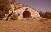
September 25, 1997 1 mi (1.6 km) northwest of Guernsey
42°19′11″N 104°48′17″W / 42.319722°N 104.804722°WGuernsey 6 Oregon Trail Ruts 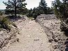
October 15, 1966 Southern side of the North Platte River, .5 mi (0.80 km) south of Guernsey
42°15′15″N 104°44′47″W / 42.254167°N 104.746389°WGuernsey 7 Patten Creek Site 
September 11, 1989 Address Restricted[4] Hartville 8 Platte County Courthouse October 15, 2008 900 9th St.
42°03′20″N 104°57′11″W / 42.055556°N 104.953056°WWheatland 9 Register Cliff 
April 3, 1970 Southeast of Guernsey on the North Platte River Guernsey 10 Sunrise Mine Historic District December 23, 2005 Wyoming Highway 318
42°19′55″N 104°42′11″W / 42.331944°N 104.703056°WHartville 11 Swan Land and Cattle Company Headquarters 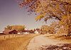
October 15, 1966 Eastern side of Chugwater
41°44′54″N 104°49′05″W / 41.748333°N 104.818056°WChugwater 12 Wheatland Railroad Depot February 16, 1996 701 Gilchrist Ave.
42°03′15″N 104°57′03″W / 42.054167°N 104.950833°WWheatland See also
- List of National Historic Landmarks in Wyoming
- National Register of Historic Places listings in Wyoming
References
- ^ The latitude and longitude information provided in this table was derived originally from the National Register Information System, which has been found to be fairly accurate for about 99% of listings. For about 1% of NRIS original coordinates, experience has shown that one or both coordinates are typos or otherwise extremely far off; some corrections may have been made. A more subtle problem causes many locations to be off by up to 150 yards, depending on location in the country: most NRIS coordinates were derived from tracing out latitude and longitudes off of USGS topographical quadrant maps created under the North American Datum of 1927, which differs from the current, highly accurate WGS84 GPS system used by Google maps. Chicago is about right, but NRIS longitudes in Washington are higher by about 4.5 seconds, and are lower by about 2.0 seconds in Maine. Latitudes differ by about 1.0 second in Florida. Some locations in this table may have been corrected to current GPS standards.
- ^ "National Register of Historic Places: Weekly List Actions". National Park Service, United States Department of the Interior. Retrieved on November 10, 2011.
- ^ Numbers represent an ordering by significant words. Various colorings, defined here, differentiate National Historic Landmark sites and National Register of Historic Places Districts from other NRHP buildings, structures, sites or objects.
- ^ Some listings on the NRHP are highly sensitive sites and may be subject to looting or vandalism. The NRHP lists this site as "Address Restricted."
U.S. National Register of Historic Places Topics Lists by states Alabama • Alaska • Arizona • Arkansas • California • Colorado • Connecticut • Delaware • Florida • Georgia • Hawaii • Idaho • Illinois • Indiana • Iowa • Kansas • Kentucky • Louisiana • Maine • Maryland • Massachusetts • Michigan • Minnesota • Mississippi • Missouri • Montana • Nebraska • Nevada • New Hampshire • New Jersey • New Mexico • New York • North Carolina • North Dakota • Ohio • Oklahoma • Oregon • Pennsylvania • Rhode Island • South Carolina • South Dakota • Tennessee • Texas • Utah • Vermont • Virginia • Washington • West Virginia • Wisconsin • WyomingLists by territories Lists by associated states Other Municipalities and communities of Platte County, Wyoming Towns 
CDPs Categories:- National Register of Historic Places in Wyoming by county
- Platte County, Wyoming
-


Wikimedia Foundation. 2010.