- National Register of Historic Places listings in Otoe County, Nebraska
-
 Location of Otoe County in Nebraska
This is a list of the National Register of Historic Places listings in Otoe County, Nebraska. It is intended to be a complete list of the properties and districts on the National Register of Historic Places in Otoe County, Nebraska, United States. The locations of National Register properties and districts for which the latitude and longitude coordinates are included below, may be seen in a Google map.[1]
There are 26 properties and districts listed on the National Register in the county, including 1 National Historic Landmark.
-
- This National Park Service list is complete through NPS recent listings posted November 10, 2011.[2]
Listings county-wide
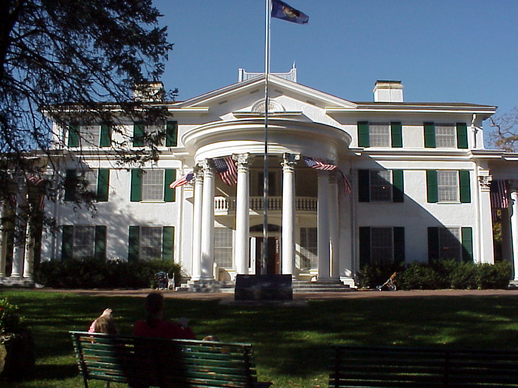
[3] Landmark name Image Date listed Location City or town Summary 1 Arbor Lodge 
April 16, 1969 Arbor Lodge State Park, west of Nebraska City
40°40′49″N 95°52′42″W / 40.680278°N 95.878333°WNebraska City 2 Boscobel June 17, 1976 North of Nebraska City on Steamwagon Rd.
40°40′59″N 95°52′36″W / 40.683056°N 95.876667°WNebraska City 3 Bridge June 29, 1992 County road over an unnamed stream, 1.5 miles southwest of Nebraska City
40°39′39″N 95°52′41″W / 40.660833°N 95.878056°WNebraska City 4 Bridge June 29, 1992 County road over an unnamed stream, 4.1 miles southwest of Lorton
40°34′01″N 96°05′26″W / 40.566944°N 96.090556°WLorton 5 Camp Creek Cemetery and Chapel March 21, 2011 Northeast corner of County Road P and S. 70th Rd.
40°34′04″N 95°48′08″W / 40.567778°N 95.802222°WNebraska City vicinity 6 Camp Creek School, Otoe County District No. 54 June 5, 1980 Southeast of Nebraska City on Rural Route 3
40°33′08″N 95°48′41″W / 40.552222°N 95.811389°WNebraska City 7 Grand Army of the Republic (G.A.R.) Memorial Hall February 25, 1994 908 1st Corso
40°40′33″N 95°51′24″W / 40.675833°N 95.856667°WNebraska City 8 Harmony School, School District No. 53 July 22, 2005 Address Restricted Nebraska City 9 Kregel Wind Mill Company 
February 25, 1993 1416 Central Ave.
40°40′37″N 95°51′48″W / 40.676944°N 95.863333°WNebraska City 10 George F. Lee Octagon Houses November 23, 1977 South of Nebraska City off U.S. Route 73
40°34′19″N 95°48′10″W / 40.571944°N 95.802778°WNebraska City 11 Little Nemaha River Bridge (Syracuse) June 29, 1992 County road over the Little Nemaha River, 3 miles northwest of Syracuse
40°40′00″N 96°14′09″W / 40.666667°N 96.235833°WSyracuse 12 Little Nemaha River Bridge (Dunbar) June 29, 1992 County road over the Little Nemaha River, 1.8 miles northwest of Dunbar
40°40′57″N 96°02′42″W / 40.6825°N 96.045°WDunbar 13 Mayhew Cabin February 11, 2011 2012 4th Corso
40°40′24″N 95°52′12″W / 40.673333°N 95.87°WNebraska City 14 McCartney School District 17 November 15, 2000 Junction of Steamwagon Rd. and CTH 59
40°41′03″N 95°55′05″W / 40.684167°N 95.918056°WNebraska City 15 Morton-James Public Library May 28, 1976 11th St. and 1st Corso
40°40′32″N 95°51′25″W / 40.675556°N 95.856944°WNebraska City 16 Nebraska City Burlington Depot August 8, 1997 Junction of 6th and Corso Sts.
40°40′19″N 95°51′09″W / 40.671944°N 95.8525°WNebraska City 17 Nebraska City Historic District 
October 29, 1976 Roughly bounded by 5th Ave., 3rd, 19th, and 1st Corso Sts.
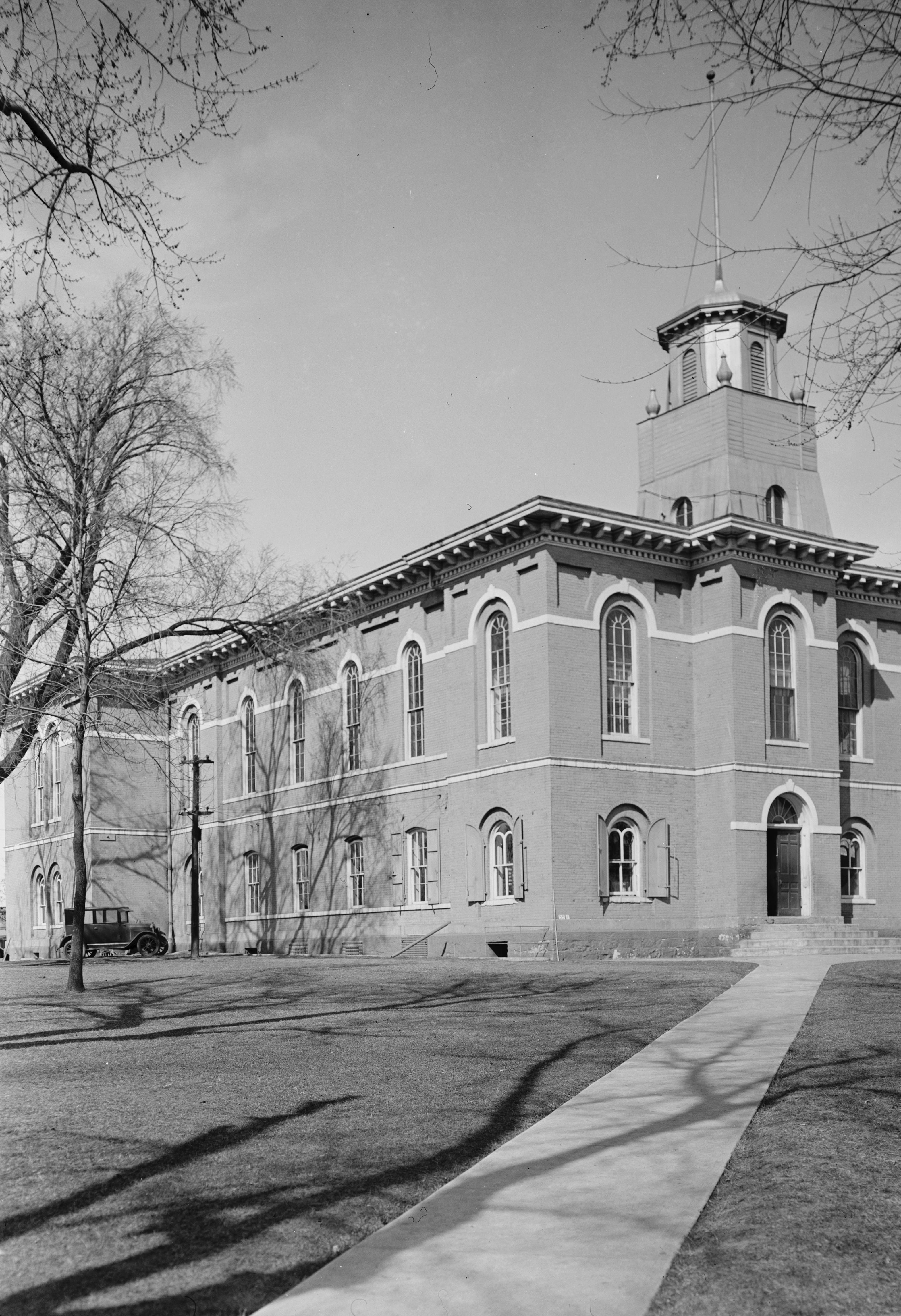
40°40′43″N 95°51′30″W / 40.678611°N 95.858333°WNebraska City 18 Otoe County Courthouse 
June 18, 1976 10th St. and Central Ave.
40°40′34″N 95°51′29″W / 40.676111°N 95.858056°WNebraska City 19 St. Benedict's Catholic Church 
January 27, 1983 411 5th Rue
40°40′11″N 95°50′26″W / 40.669722°N 95.840556°WNebraska City 20 South 13th Street Historic District October 29, 1976 Roughly bounded by 12th, 14th, 1st Corso, and 6th Corso Sts.
40°40′24″N 95°51′39″W / 40.673333°N 95.860833°WNebraska City 21 South Nebraska City Historic District October 22, 1976 Roughly bounded by 4th, 11th, 1st Corso, and 4th Corso Sts.
40°40′27″N 95°51′14″W / 40.674167°N 95.853889°WNebraska City 22 U.S. Post Office September 3, 1971 202 S. 8th St.
40°40′31″N 95°51′18″W / 40.675278°N 95.855°WNebraska City 23 Unadilla Main Street Historic District February 17, 1995 Northern side of Main St. between G and H Sts.
40°40′54″N 96°16′20″W / 40.681667°N 96.272222°WUnadilla 24 Jasper A. Ware House July 16, 1973 South of Nebraska City on Steinhart Park Rd.
40°40′18″N 95°52′48″W / 40.671667°N 95.88°WNebraska City 25 Wolf Creek Bridge June 29, 1992 Vacated county road over Wolf Creek, 10.3 miles northeast of Dunbar
40°47′02″N 95°54′57″W / 40.783889°N 95.915833°WDunbar 26 Wyoming Bridge June 29, 1992 County road over Squaw Creek, 9.1 miles northeast of Dunbar
40°44′43″N 95°53′32″W / 40.745278°N 95.892222°WDunbar See also
- List of National Historic Landmarks in Nebraska
- National Register of Historic Places listings in Nebraska
References
- ^ The latitude and longitude information provided in this table was derived originally from the National Register Information System, which has been found to be fairly accurate for about 99% of listings. For about 1% of NRIS original coordinates, experience has shown that one or both coordinates are typos or otherwise extremely far off; some corrections may have been made. A more subtle problem causes many locations to be off by up to 150 yards, depending on location in the country: most NRIS coordinates were derived from tracing out latitude and longitudes off of USGS topographical quadrant maps created under the North American Datum of 1927, which differs from the current, highly accurate WGS84 GPS system used by Google maps. Chicago is about right, but NRIS longitudes in Washington are higher by about 4.5 seconds, and are lower by about 2.0 seconds in Maine. Latitudes differ by about 1.0 second in Florida. Some locations in this table may have been corrected to current GPS standards.
- ^ "National Register of Historic Places: Weekly List Actions". National Park Service, United States Department of the Interior. Retrieved on November 10, 2011.
- ^ Numbers represent an ordering by significant words. Various colorings, defined here, differentiate National Historic Landmark sites and National Register of Historic Places Districts from other NRHP buildings, structures, sites or objects.
U.S. National Register of Historic Places Topics Lists by states Alabama • Alaska • Arizona • Arkansas • California • Colorado • Connecticut • Delaware • Florida • Georgia • Hawaii • Idaho • Illinois • Indiana • Iowa • Kansas • Kentucky • Louisiana • Maine • Maryland • Massachusetts • Michigan • Minnesota • Mississippi • Missouri • Montana • Nebraska • Nevada • New Hampshire • New Jersey • New Mexico • New York • North Carolina • North Dakota • Ohio • Oklahoma • Oregon • Pennsylvania • Rhode Island • South Carolina • South Dakota • Tennessee • Texas • Utah • Vermont • Virginia • Washington • West Virginia • Wisconsin • WyomingLists by territories Lists by associated states Other Municipalities and communities of Otoe County, Nebraska Cities 
Villages Categories:- National Register of Historic Places in Nebraska by county
- Otoe County, Nebraska
- Buildings and structures in Otoe County, Nebraska
-


Wikimedia Foundation. 2010.