- National Register of Historic Places listings in Missoula County, Montana
-
 Location of Missoula County in Montana
This is a list of the National Register of Historic Places listings in Missoula County, Montana. It is intended to be a complete list of the properties and districts on the National Register of Historic Places in Missoula County, Montana, United States. The locations of National Register properties and districts for which the latitude and longitude coordinates are included below, may be seen in a Google map.[1]
There are 79 properties and districts listed on the National Register in the county, including 2 National Historic Landmarks.
-
- This National Park Service list is complete through NPS recent listings posted November 10, 2011.[2]
Listings county-wide
[3] Landmark name Image Date listed Location City or town Summary 1 Apartment Building at 116 Spruce Street April 30, 1990 116 W. Spruce St.
46°52′28″N 113°59′32″W / 46.874444°N 113.992222°WMissoula 2 Atlantic Hotel 
April 30, 1990 519 N. Higgins Ave.
46°52′29″N 113°59′30″W / 46.874722°N 113.991667°WMissoula 3 Bellows House February 22, 1996 1637 S. Higgins Ave.
46°51′19″N 113°59′49″W / 46.855278°N 113.996944°WMissoula 4 Belmont Hotel 
April 20, 1983 430 N. Higgins Ave.
46°52′25″N 113°59′30″W / 46.873611°N 113.991667°WMissoula 5 Bluebird Building August 8, 1996 220-224 N. Higgins Ave.
46°52′17″N 113°59′36″W / 46.871389°N 113.993333°WMissoula 6 Brunswick Hotel April 30, 1990 223 Railroad St.
46°52′35″N 113°59′37″W / 46.876389°N 113.993611°WMissoula 7 Camp Paxson Boy Scout Camp (24MO77) March 21, 1986 Seeley Lake
47°11′14″N 113°31′04″W / 47.187222°N 113.517778°WLolo National Forest 8 Carlton Community Church September 23, 2011 20075 Old MT 93
46°40′39″N 114°04′46″W / 46.6775°N 114.079444°WFlorence vicinity 9 Carnegie Public Library April 30, 1982 335 N. Pattee St.
46°52′21″N 113°59′29″W / 46.8725°N 113.991389°WMissoula 10 Thomas J. Christie House March 16, 1995 401 McLeod Ave.
46°51′32″N 113°59′28″W / 46.858889°N 113.991111°WMissoula 11 Cook Farm May 16, 1996 5185 Old Marshall Grade Rd.
46°52′39″N 113°55′49″W / 46.8775°N 113.930278°WMissoula 12 DeSmet Schoolhouse February 28, 1991 6105 Old Highway 10, W.
46°55′46″N 114°05′47″W / 46.929444°N 114.096389°WMissoula 13 Dixon-Duncan Block October 17, 1997 232-240 N. Higgins Ave.
46°52′18″N 113°59′35″W / 46.871667°N 113.993056°WMissoula 14 East Pine Street Historic District July 13, 1989 Roughly bounded by E. Pine St., Madison St., E. Broadway, and Pattee St.
46°52′18″N 113°59′18″W / 46.871667°N 113.988333°WMissoula 15 Evaro School May 1, 2003 6688 Grooms Rd.
47°02′02″N 114°05′23″W / 47.033889°N 114.089722°WEvaro 16 Florence Hotel 
June 18, 1992 111 N. Higgins Ave.
46°52′13″N 113°59′40″W / 46.870278°N 113.994444°WMissoula 17 Flynn Farm March 19, 1980 West of Missoula on Mullan Rd.
46°53′30″N 114°03′54″W / 46.891667°N 114.065°WMissoula 18 Forkenbrock Funeral Home December 27, 1984 234 E. Pine St.
46°52′21″N 113°59′22″W / 46.8725°N 113.989444°WMissoula 19 Fort Fizzle Site July 21, 1977 5 miles west of Lolo
46°44′48″N 114°10′19″W / 46.746667°N 114.171944°WLolo 20 Fort Missoula Historic District 
April 29, 1987 Reserve St. and South Ave.
46°50′34″N 114°03′16″W / 46.842778°N 114.054444°WMissoula 21 Garden City Drug April 30, 1990 118 N. Higgins Ave.
46°52′14″N 113°59′38″W / 46.870556°N 113.993889°WMissoula 22 A.J. Gibson House April 16, 1980 402 S. 2nd St.
46°51′36″N 114°01′39″W / 46.86°N 114.0275°WMissoula 23 Gleim Building 
April 30, 1990 265 W. Front St.
46°52′20″N 113°59′50″W / 46.872222°N 113.997222°WMissoula 24 Gleim Building II March 9, 1995 255-257 W. Front St.
46°52′20″N 113°59′50″W / 46.872222°N 113.997222°WMissoula 25 Grand Pacific Hotel September 29, 1983 118 W. Alder
46°52′31″N 113°59′29″W / 46.875278°N 113.991389°WMissoula 26 Hammond Arcade April 30, 1990 101 S. Higgins Ave.
46°52′12″N 113°59′42″W / 46.87°N 113.995°WMissoula 27 Headquarters Building and Daily Company Annex May 17, 1996 113-119 W. Front St.
46°52′13″N 113°59′42″W / 46.870278°N 113.995°WMissoula 28 Hellgate Lodge 383 BPOE April 30, 1990 120 N. Pattee St.
46°52′13″N 113°59′32″W / 46.870278°N 113.992222°WMissoula 29 J.M. Herzog House September 12, 1985 1210 Toole Ave.
46°52′42″N 114°00′28″W / 46.878333°N 114.007778°WMissoula 30 Higgins Block October 1, 1979 202 N. Higgins Ave.
46°52′17″N 113°59′36″W / 46.871389°N 113.993333°WMissoula 31 Independent Telephone Company Building April 30, 1990 207 E. Main St.
46°52′14″N 113°59′30″W / 46.870556°N 113.991667°WMissoula 32 John S. Johnston House August 2, 1984 412 W. Alder St.
46°52′36″N 113°59′47″W / 46.876667°N 113.996389°WMissoula 33 John M. Keith House July 7, 1983 1110 Gerald Ave.
46°51′39″N 113°59′40″W / 46.860833°N 113.994444°WMissoula 34 Knowles Building April 9, 1987 200-210 S. 3rd St., W.
46°52′03″N 113°59′54″W / 46.8675°N 113.998333°WMissoula 35 Labor Temple April 30, 1990 208 E. Main St.
46°52′15″N 113°59′29″W / 46.870833°N 113.991389°WMissoula 36 Laird's Lodge Historic District August 17, 1990 Northern end of Lindbergh Lake at the end of Lindbergh Lake Rd.
47°24′19″N 113°43′04″W / 47.405278°N 113.717778°WSeeley Lake 37 Lenox Flats August 8, 2000 300-306 West Broadway
46°52′24″N 113°59′45″W / 46.873333°N 113.995833°WMissoula 38 Lincoln School June 3, 1997 1209 Lolo St.
46°53′04″N 113°57′52″W / 46.884444°N 113.964444°WMissoula 39 Lolo Trail 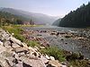
October 15, 1966 Parallel to U.S. Route 12 on the ridges of the Bitterroot Mountains from Lolo Pass to Weippe
46°38′06″N 114°34′47″W / 46.635111°N 114.579689°WBitterroot Mountains Extends into Clearwater County, Idaho 40 Lower Rattlesnake Historic District June 10, 1999 Roughly bounded by Vene St., Greenough Park, Elm St., and Pierce St.
46°52′18″N 113°58′37″W / 46.871667°N 113.976944°WMissoula 41 Lucy Building April 30, 1990 330 N. Higgins Ave.
46°52′23″N 113°59′32″W / 46.873056°N 113.992222°WMissoula 42 Marsh and Powell Funeral Home April 30, 1990 224 W. Spruce St.
46°52′30″N 113°59′39″W / 46.875°N 113.994167°WMissoula 43 Masonic Lodge 
April 30, 1990 120-136 E. Broadway Ave.
46°52′19″N 113°59′32″W / 46.871944°N 113.992222°WMissoula 44 McCormick Neighborhood Historic District May 19, 2004 Roughly bounded by River Rd., S. 6th, W., S. Orange St., and the Bitterroot Line of the railroad
46°51′58″N 114°00′24″W / 46.866111°N 114.006667°WMissoula 45 Milwaukee Depot April 30, 1982 250 Station Dr.
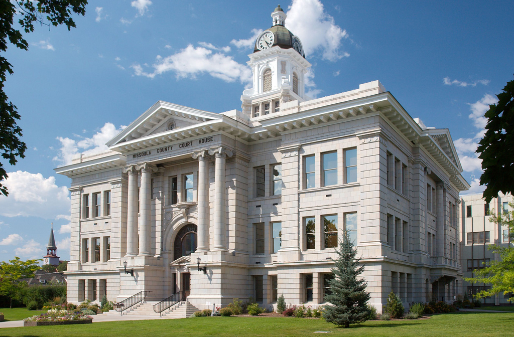
46°52′03″N 113°59′51″W / 46.8675°N 113.9975°WMissoula 46 Missoula County Courthouse 
September 1, 1976 220 W. Broadway
46°52′24″N 113°59′42″W / 46.873333°N 113.995°WMissoula 47 Missoula County Fairgrounds Historic District September 16, 2010 1101 South Ave., W.
46°50′55″N 114°00′53″W / 46.848611°N 114.014722°WMissoula 48 Missoula Downtown Historic District August 21, 2009 Roughly bounded by the former Northern Pacific railroad tracks, the Clark Fork River, Little McCormick Park, and Madison St.
46°52′12″N 113°59′13″W / 46.87°N 113.98694°W
Boundary increase/decrease (listed February 7, 2011): Higgins Ave. & Front St.
Boundary increase (listed April 8, 2011): Bounded by Montana Rail Link and BNSF railway, Toole-Railroad-Alder Sts.Missoula Missoula MPS 49 Missoula Laundry Company April 30, 1990 111 E. Spruce St.
46°52′26″N 113°59′29″W / 46.873889°N 113.991389°WMissoula 50 Missoula Mercantile April 30, 1990 114 N. Higgins Ave.
46°52′13″N 113°59′38″W / 46.870278°N 113.993889°WMissoula 51 Missoula Mercantile Warehouse 
April 6, 2004 221, 229, and 231 E. Front St.
46°52′10″N 113°59′32″W / 46.869444°N 113.992222°WMissoula 52 Missoula Southside Historic District March 22, 1991 Roughly bounded by the Clark Fork River, S. Higgins Ave., S. 6th St., W., and Orange St.
46°51′57″N 113°59′58″W / 46.865833°N 113.999444°WMissoula 53 Model Laundry and Apartments April 30, 1990 131 W. Alder St.
46°52′47″N 113°59′34″W / 46.879722°N 113.992778°WMissoula 54 Montgomery Ward 
April 30, 1990 201 N. Higgins Ave.
46°52′17″N 113°59′38″W / 46.871389°N 113.993889°WMissoula 55 Moon-Randolph Ranch March 1, 2010 1515 Spurlock Rd.
46°54′01″N 114°00′10″W / 46.900233°N 114.002647°WMissoula 56 Mrs. Lydia McCaffery's Furnished Rooms April 6, 2000 501 W. Alder
46°52′35″N 113°59′50″W / 46.876389°N 113.997222°WMissoula 57 Northern Pacific Railroad Depot March 28, 1985 Railroad and Higgins Ave.
46°52′32″N 113°59′25″W / 46.875556°N 113.990278°WMissoula 58 Northside Missoula Railroad Historic District May 4, 1995 Roughly bounded by Worden Ave., 6th St., Interstate 90, C St. and the former Northern Pacific railroad tracks
46°52′44″N 113°59′35″W / 46.878889°N 113.993056°WMissoula 59 Palace Hotel October 25, 1982 147 W. Broadway
46°52′20″N 113°59′40″W / 46.872222°N 113.994444°WMissoula 60 Edgar Paxson House November 6, 1986 611 Stephens Ave.
46°51′38″N 114°00′24″W / 46.860556°N 114.006667°WMissoula 61 Potomac School March 30, 1992 220 Potomac Rd.
46°52′54″N 113°34′43″W / 46.881667°N 113.578611°WPotomac 62 Clarence R. Prescott House September 26, 1985 University of Montana campus
46°51′42″N 113°58′49″W / 46.861667°N 113.980278°WMissoula 63 Reid House December 18, 2003 526 E. Front
46°52′09″N 113°59′13″W / 46.869167°N 113.986944°WMissoula 64 St. Francis Xavier Church April 28, 1982 420 W. Pine St.
46°52′29″N 113°59′48″W / 46.874722°N 113.996667°WMissoula 65 Saint John the Baptist Catholic Church March 27, 1986 Mullan Rd.
47°00′47″N 114°13′40″W / 47.013056°N 114.227778°WFrenchtown 66 Simons Block February 18, 2000 314 N. Higgins Ave.
46°52′23″N 113°59′32″W / 46.873056°N 113.992222°WMissoula 67 Stark School October 12, 1995 Ninemile Rd. in Ninemile Valley
47°07′07″N 114°29′28″W / 47.118611°N 114.491111°WHuson 68 Fred T. Sterling House July 7, 1983 1310 Gerald Ave.
46°51′32″N 113°59′40″W / 46.858889°N 113.994444°WMissoula 69 Studebaker Building April 17, 1997 216 W. Main St.
46°52′20″N 113°59′45″W / 46.872222°N 113.995833°WMissoula 70 Target Range Elementary School August 10, 2011 4095 South Ave. W
46°50′53″N 114°04′49″W / 46.848056°N 114.080278°WMissoula 71 John R. Toole House April 25, 1983 1005 Gerald Ave.
46°51′43″N 113°59′43″W / 46.861944°N 113.995278°WMissoula 72 Traveler's Rest 
October 15, 1966 1 mile south of Lolo near U.S. Route 93
46°44′24″N 114°04′06″W / 46.74°N 114.068333°WLolo 73 U.S. Forest Service Remount Depot April 10, 1980 2.4 miles southwest of Huson
47°4′4″N 114°23′56″W / 47.06778°N 114.39889°W[4]Huson 74 U.S. Post Office 
November 30, 1979 200 E. Broadway St.
46°52′20″N 113°59′26″W / 46.872222°N 113.990556°WMissoula 75 University Apartments March 28, 1985 400-422 Roosevelt Ave.
46°51′45″N 113°59′48″W / 46.8625°N 113.996667°WMissoula 76 University Area Historic District December 13, 2000 Roughly bounded by S. 4th St., E., Beckwith Ave., Arthur Ave., and Higgins Ave.
46°51′40″N 113°59′33″W / 46.861111°N 113.9925°WMissoula 77 University of Montana Historic District 
October 2, 1992 Roughly bounded by Arthur, Connell, and Beckwith Aves., and the ridge lines of Mt. Sentinel
46°51′25″N 113°58′35″W / 46.856944°N 113.976389°WMissoula 78 Wilma Theatre 
December 31, 1979 104 S. Higgins Ave.
46°52′08″N 113°59′43″W / 46.868889°N 113.995278°WMissoula 79 Zip Auto April 30, 1990 251 W. Main St.
46°52′19″N 113°59′47″W / 46.871944°N 113.996389°WMissoula See also
- List of National Historic Landmarks in Montana
- National Register of Historic Places listings in Montana
References
- ^ The latitude and longitude information provided in this table was derived originally from the National Register Information System, which has been found to be fairly accurate for about 99% of listings. For about 1% of NRIS original coordinates, experience has shown that one or both coordinates are typos or otherwise extremely far off; some corrections may have been made. A more subtle problem causes many locations to be off by up to 150 yards, depending on location in the country: most NRIS coordinates were derived from tracing out latitude and longitudes off of USGS topographical quadrant maps created under the North American Datum of 1927, which differs from the current, highly accurate WGS84 GPS system used by Google maps. Chicago is about right, but NRIS longitudes in Washington are higher by about 4.5 seconds, and are lower by about 2.0 seconds in Maine. Latitudes differ by about 1.0 second in Florida. Some locations in this table may have been corrected to current GPS standards.
- ^ "National Register of Historic Places: Weekly List Actions". National Park Service, United States Department of the Interior. Retrieved on November 10, 2011.
- ^ Numbers represent an ordering by significant words. Various colorings, defined here, differentiate National Historic Landmark sites and National Register of Historic Places Districts from other NRHP buildings, structures, sites or objects.
- ^ Location derived from Ninemile Remount Depot and Historic Ranger Station website
U.S. National Register of Historic Places Topics Lists by states Alabama • Alaska • Arizona • Arkansas • California • Colorado • Connecticut • Delaware • Florida • Georgia • Hawaii • Idaho • Illinois • Indiana • Iowa • Kansas • Kentucky • Louisiana • Maine • Maryland • Massachusetts • Michigan • Minnesota • Mississippi • Missouri • Montana • Nebraska • Nevada • New Hampshire • New Jersey • New Mexico • New York • North Carolina • North Dakota • Ohio • Oklahoma • Oregon • Pennsylvania • Rhode Island • South Carolina • South Dakota • Tennessee • Texas • Utah • Vermont • Virginia • Washington • West Virginia • Wisconsin • WyomingLists by territories Lists by associated states Other Municipalities and communities of Missoula County, Montana City 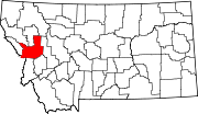
CDPs Bonner-West Riverside | Clinton | East Missoula | Evaro | Frenchtown | Lolo | Orchard Homes | Seeley Lake | Wye
Unincorporated
communitiesGhost town Hell Gate | Coloma
Indian reservation Footnotes ‡This populated place also has portions in an adjacent county or counties
Categories:- National Register of Historic Places in Montana by county
- Missoula County, Montana
-


Wikimedia Foundation. 2010.