- National Register of Historic Places listings in Lemhi County, Idaho
-
 Location of Lemhi County in Idaho
This is a list of the National Register of Historic Places listings in Lemhi County, Idaho.
This is intended to be a complete list of the properties and districts on the National Register of Historic Places in Lemhi County, Idaho, United States. Latitude and longitude coordinates are provided for many National Register properties and districts; these locations may be seen together in a Google map.[1]
There are 15 properties and districts listed on the National Register in the county, including 1 National Historic Landmark. More may be added; properties and districts nationwide are added to the Register weekly.[2]
-
- This National Park Service list is complete through NPS recent listings posted November 10, 2011.[3]
Current listings
[4] Landmark name [5] Image Date listed Location City or town Summary 1 Charcoal Kilns 
February 23, 1972 Off State Highway 28
44°18′40″N 113°10′44″W / 44.311111°N 113.178889°WLeadore 2 Episcopal Church of the Redeemer January 12, 1979 1st, N. and Fulton Sts.
45°10′44″N 113°54′02″W / 45.178889°N 113.900556°WSalmon 3 First Flag Unfurling Site, Lewis and Clark Trail August 22, 1975 5 miles north of Tendoy in the Bitterroot Mountains
45°01′21″N 113°34′27″W / 45.0225°N 113.574167°WTendoy 4 Fort Lemhi February 23, 1972 Address Restricted[6] Tendoy 5 Lars Geertson House April 3, 1980 Southeast of Salmon
45°07′44″N 113°46′42″W / 45.128889°N 113.778333°WSalmon 6 Leesburg 
April 4, 1975 West of Salmon at Napias Creek in the Salmon National Forest
45°13′32″N 114°06′44″W / 45.225556°N 114.112222°WSalmon 7 Lemhi Boarding School Girls Dormitory November 12, 1998 Hayden Creek Rd., 1/8 mile southeast of its junction with U.S. Route 93
44°51′43″N 113°37′48″W / 44.861944°N 113.63°WLemhi 8 Lemhi County Courthouse February 7, 1978 1st St., N. and Broadway
45°10′45″N 113°54′04″W / 45.179167°N 113.901111°WSalmon 9 Lemhi Pass 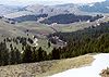
October 15, 1966 12 miles east of Tendoy off State Highway 28, in the Beaverhead and Salmon National Forests
44°58′04″N 113°27′23″W / 44.967778°N 113.456389°WTendoy 10 Socrates A. Myers House December 2, 1977 300 Hall St.
45°10′44″N 113°53′37″W / 45.178889°N 113.893611°WSalmon 11 Odd Fellows Hall February 7, 1978 516 Main St.
45°10′32″N 113°53′32″W / 45.175556°N 113.892222°WSalmon 12 Salmon City Hall and Library 
November 17, 1982 200 Main St.
45°10′32″N 113°53′32″W / 45.175556°N 113.892222°WSalmon 13 Salmon Odd Fellows Hall August 25, 1978 510-514 Main St.
45°10′32″N 113°53′32″W / 45.175556°N 113.892222°WSalmon 14 Shoup Building March 31, 1978 Center and Main Sts.
45°10′30″N 113°53′33″W / 45.175°N 113.8925°WSalmon 15 Shoup Rock Shelters November 8, 1974 Address Restricted[6] Cobalt See also
References
- ^ The latitude and longitude information provided in this table was derived originally from the National Register Information System, which has been found to be fairly accurate for about 99% of listings. For about 1% of NRIS original coordinates, experience has shown that one or both coordinates are typos or otherwise extremely far off; some corrections may have been made. A more subtle problem causes many locations to be off by up to 150 yards, depending on location in the country: most NRIS coordinates were derived from tracing out latitude and longitudes off of USGS topographical quadrant maps created under the North American Datum of 1927, which differs from the current, highly accurate WGS84 GPS system used by Google maps. Chicago is about right, but NRIS longitudes in Washington are higher by about 4.5 seconds, and are lower by about 2.0 seconds in Maine. Latitudes differ by about 1.0 second in Florida. Some locations in this table may have been corrected to current GPS standards.
- ^ "National Register of Historic Places: Weekly List Actions". National Park Service. http://www.cr.nps.gov/nr/nrlist.htm. Retrieved March 29, 2009.
- ^ "National Register of Historic Places: Weekly List Actions". National Park Service, United States Department of the Interior. Retrieved on November 10, 2011.
- ^ Numbers represent an ordering by significant words. Various colorings, defined here, differentiate National Historic Landmark sites and National Register of Historic Places Districts from other NRHP buildings, structures, sites or objects.
- ^ "National Register Information System". National Register of Historic Places. National Park Service. . http://nrhp.focus.nps.gov/natreg/docs/All_Data.html.
- ^ a b Some listings on the NRHP are highly sensitive sites and may be subject to looting or vandalism. The NRHP lists this site as "Address Restricted."
Properties on the National Register of Historic Places in Idaho  Ada • Adams • Bannock • Bear Lake • Benewah • Bingham • Blaine • Boise • Bonner • Bonneville • Boundary • Butte • Camas • Canyon • Caribou • Cassia • Clark • Clearwater • Custer • Elmore • Franklin • Fremont • Gem • Gooding • Idaho • Jefferson • Jerome • Kootenai • Latah • Lemhi • Lewis • Lincoln • Madison • Minidoka • Nez Perce • Oneida • Owyhee • Payette • Power • Shoshone • Teton • Twin Falls • Valley • Washington
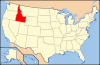
U.S. National Register of Historic Places Topics Lists by states Alabama • Alaska • Arizona • Arkansas • California • Colorado • Connecticut • Delaware • Florida • Georgia • Hawaii • Idaho • Illinois • Indiana • Iowa • Kansas • Kentucky • Louisiana • Maine • Maryland • Massachusetts • Michigan • Minnesota • Mississippi • Missouri • Montana • Nebraska • Nevada • New Hampshire • New Jersey • New Mexico • New York • North Carolina • North Dakota • Ohio • Oklahoma • Oregon • Pennsylvania • Rhode Island • South Carolina • South Dakota • Tennessee • Texas • Utah • Vermont • Virginia • Washington • West Virginia • Wisconsin • WyomingLists by territories Lists by associated states Other Municipalities and communities of Lemhi County, Idaho Cities 
Unincorporated
communitiesCarmen | Cobalt | Elk Bend | Gibbonsville | Leesburg | Lemhi | May | North Fork | Patterson | Shoup | Tendoy
Categories:- National Register of Historic Places in Idaho by county
- Lemhi County, Idaho
-


Wikimedia Foundation. 2010.