- National Register of Historic Places listings in Lee County, Mississippi
-
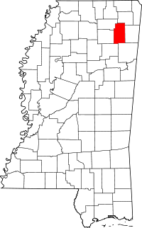 Location of Lee County in Mississippi
This is a list of the National Register of Historic Places listings in Lee County, Mississippi.
This is intended to be a complete list of the properties and districts on the National Register of Historic Places in Lee County, Mississippi, United States. Latitude and longitude coordinates are provided for many National Register properties and districts; these locations may be seen together in a Google map.[1]
There are 22 properties and districts listed on the National Register in the county.
-
- This National Park Service list is complete through NPS recent listings posted November 10, 2011.[2]
Current listings
[3] Landmark name [4] Image Date listed Location City or town Summary 1 Baldwyn Historic District July 20, 2011 Roughly along E. & W. Main Sts. & N. & S. 2nd Ave.
34°30′33″N 88°38′01″W / 34.509167°N 88.633611°WBaldwyn 2 Brices Cross Roads National Battlefield Site 
October 15, 1966 6 miles west of Baldwyn on Mississippi Highway 370
34°30′24″N 88°43′44″W / 34.50667°N 88.72889°WBaldwyn 3 Barlow Burrow House March 1, 1984 157 N. 2nd St.
34°22′45″N 88°40′53″W / 34.379167°N 88.681389°WSaltillo 4 Carnation Milk Factory August 20, 2009 520 Carnation St.
34°15′14″N 88°42′34″W / 34.253889°N 88.709444°WTupelo 5 R.C. Clark House November 5, 2010 215 N. Church St.
34°15′31″N 88°42′31″W / 34.258611°N 88.708611°WTupelo 6 First Methodist Church 
March 15, 1990 412 W. Main St.
34°15′28″N 88°42′27″W / 34.257778°N 88.7075°WTupelo 7 R.F. Goodlett House April 3, 1992 219 Broadway
34°15′31″N 88°42′20″W / 34.258611°N 88.705556°WTupelo 8 Highland Circle Historic District March 20, 2006 Highland Circle neighborhood, including parts of N. Madison St., Highland Circle, Oak Grove Rd., and W. Jackson St.
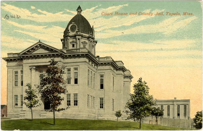
34°16′01″N 88°42′43″W / 34.266944°N 88.711944°WTupelo 9 Lee County Courthouse 
April 3, 1992 Court St. between Spring and Broadway
34°15′31″N 88°42′17″W / 34.258611°N 88.704722°WTupelo 10 Mill Village Historic District April 3, 1992 Roughly bounded by the Illinois Central and St. Louis – San Francisco railroad tracks and Chestnut and Green Sts.
34°15′08″N 88°42′19″W / 34.252222°N 88.705278°WTupelo 11 Mutt-Thomason Site August 31, 1978 Address Restricted Tupelo 12 North Broadway Historic District October 31, 1985 300 block of N. Broadway St.
34°15′37″N 88°42′20″W / 34.260278°N 88.705556°WTupelo 13 North Church Primary School April 3, 1992 Southwestern corner of the junction of Church and Jackson Sts.
34°15′48″N 88°42′33″W / 34.263333°N 88.709167°WTupelo 14 Old Superintendent's House, Tupelo Fish Hatchery July 14, 1992 111 Elizabeth St.
34°14′55″N 88°42′07″W / 34.248611°N 88.701944°WTupelo 15 Peoples Bank and Trust Company August 24, 1978 211 Main St.
34°15′26″N 88°42′17″W / 34.257222°N 88.704722°WTupelo 16 South Church Street Historic District April 3, 1992 602-713 S. Church St.
34°15′05″N 88°42′30″W / 34.251389°N 88.708333°WTupelo 17 Spain House March 21, 2011 553 W. Main St.
34°15′26″N 88°42′37″W / 34.257222°N 88.710278°WTupelo 18 F.L. Spight House April 3, 1992 363 N. Broadway
34°15′41″N 88°42′20″W / 34.261389°N 88.705556°WTupelo 19 Stewart-Anderson House June 24, 1994 433 N. Church St.
34°15′45″N 88°42′34″W / 34.2625°N 88.709444°WTupelo 20 Tombigbee State Park March 25, 1999 Mississippi Highway 2 off Mississippi Highway 78, southeast of Tupelo
34°13′51″N 88°37′24″W / 34.230833°N 88.623333°WTupelo 21 Tupelo Homesteads 
February 7, 1997 County Roads 657 and 665 and County Drive 647, south of its junction with the Natchez Trace Parkway
34°19′34″N 88°42′27″W / 34.326111°N 88.7075°WTupelo 22 Tupelo National Battlefield 
October 15, 1966 On Mississippi Highway 6 about 1 mile west of its junction with U.S. Route 45
34°15′19″N 88°44′14″W / 34.25528°N 88.73722°WTupelo See also
- List of National Historic Landmarks in Mississippi
- National Register of Historic Places listings in Mississippi
References
- ^ The latitude and longitude information provided in this table was derived originally from the National Register Information System, which has been found to be fairly accurate for about 99% of listings. For about 1% of NRIS original coordinates, experience has shown that one or both coordinates are typos or otherwise extremely far off; some corrections may have been made. A more subtle problem causes many locations to be off by up to 150 yards, depending on location in the country: most NRIS coordinates were derived from tracing out latitude and longitudes off of USGS topographical quadrant maps created under the North American Datum of 1927, which differs from the current, highly accurate WGS84 GPS system used by Google maps. Chicago is about right, but NRIS longitudes in Washington are higher by about 4.5 seconds, and are lower by about 2.0 seconds in Maine. Latitudes differ by about 1.0 second in Florida. Some locations in this table may have been corrected to current GPS standards.
- ^ "National Register of Historic Places: Weekly List Actions". National Park Service, United States Department of the Interior. Retrieved on November 10, 2011.
- ^ Numbers represent an ordering by significant words. Various colorings, defined here, differentiate National Historic Landmark sites and National Register of Historic Places Districts from other NRHP buildings, structures, sites or objects.
- ^ "National Register Information System". National Register of Historic Places. National Park Service. . http://nrhp.focus.nps.gov/natreg/docs/All_Data.html.
U.S. National Register of Historic Places Topics Lists by states Alabama • Alaska • Arizona • Arkansas • California • Colorado • Connecticut • Delaware • Florida • Georgia • Hawaii • Idaho • Illinois • Indiana • Iowa • Kansas • Kentucky • Louisiana • Maine • Maryland • Massachusetts • Michigan • Minnesota • Mississippi • Missouri • Montana • Nebraska • Nevada • New Hampshire • New Jersey • New Mexico • New York • North Carolina • North Dakota • Ohio • Oklahoma • Oregon • Pennsylvania • Rhode Island • South Carolina • South Dakota • Tennessee • Texas • Utah • Vermont • Virginia • Washington • West Virginia • Wisconsin • WyomingLists by territories Lists by associated states Other Municipalities and communities of Lee County, Mississippi Cities 
Towns Community Mooreville
Footnotes ‡This populated place also has portions in an adjacent county or counties
Categories:- Lee County, Mississippi
- National Register of Historic Places in Mississippi by county
- Buildings and structures in Lee County, Mississippi
-


Wikimedia Foundation. 2010.