- National Register of Historic Places listings in Lawrence County, Pennsylvania
-
 Location of Lawrence County in Pennsylvania
This is a list of the National Register of Historic Places listings in Lawrence County, Pennsylvania.
This is intended to be a complete list of the properties and districts on National Register of Historic Places in Lawrence County, Pennsylvania, United States. The locations of National Register properties and districts for which the latitude and longitude coordinates are included below, may be seen in a Google map.[1]
There are 9 properties and districts listed on the National Register in the county.
-
- This National Park Service list is complete through NPS recent listings posted November 10, 2011.[2]
Current listings
[3] Landmark name[4] Image Date listed Location City or Town Summary 1 Banks Covered Bridge 
June 27, 1980 Southeast of New Wilmington on Township 476
41°5′26″N 80°17′10″W / 41.09056°N 80.28611°WWilmington Township 2 Lawrence County Courthouse 
December 15, 1978 Court Street
40°59′54″N 80°20′22″W / 40.99833°N 80.33944°WNew Castle 3 McClelland Homestead 
May 17, 1989 McClelland Road northeast of Bessemer
40°59′37″N 80°27′3″W / 40.99361°N 80.45083°WNorth Beaver Township 4 McConnell's Mill Covered Bridge 
June 27, 1980 North of Portersville and south of Rose Point on Township 415
40°57′10″N 80°10′14″W / 40.95278°N 80.17056°WSlippery Rock Township 5 New Castle Armory 
May 9, 1991 820 Frank Avenue
40°58′45″N 80°19′30″W / 40.97917°N 80.325°WShenango Township 6 North Hill Historic District 
February 18, 2000 Roughly Delaware, Neshannock, Hill Crest and Fairmont Avenues, and Crescent, Falls, Beaver, Jefferson and Mercer Streets
41°0′43″N 80°20′28″W / 41.01194°N 80.34111°WNew Castle 7 Old Homestead 
August 22, 1980 Northwest of Enon Valley off Pennsylvania Route 351
40°52′28″N 80°28′17″W / 40.87444°N 80.47139°WLittle Beaver Township 8 S.R. Thompson House 
March 7, 1985 400 Market Street
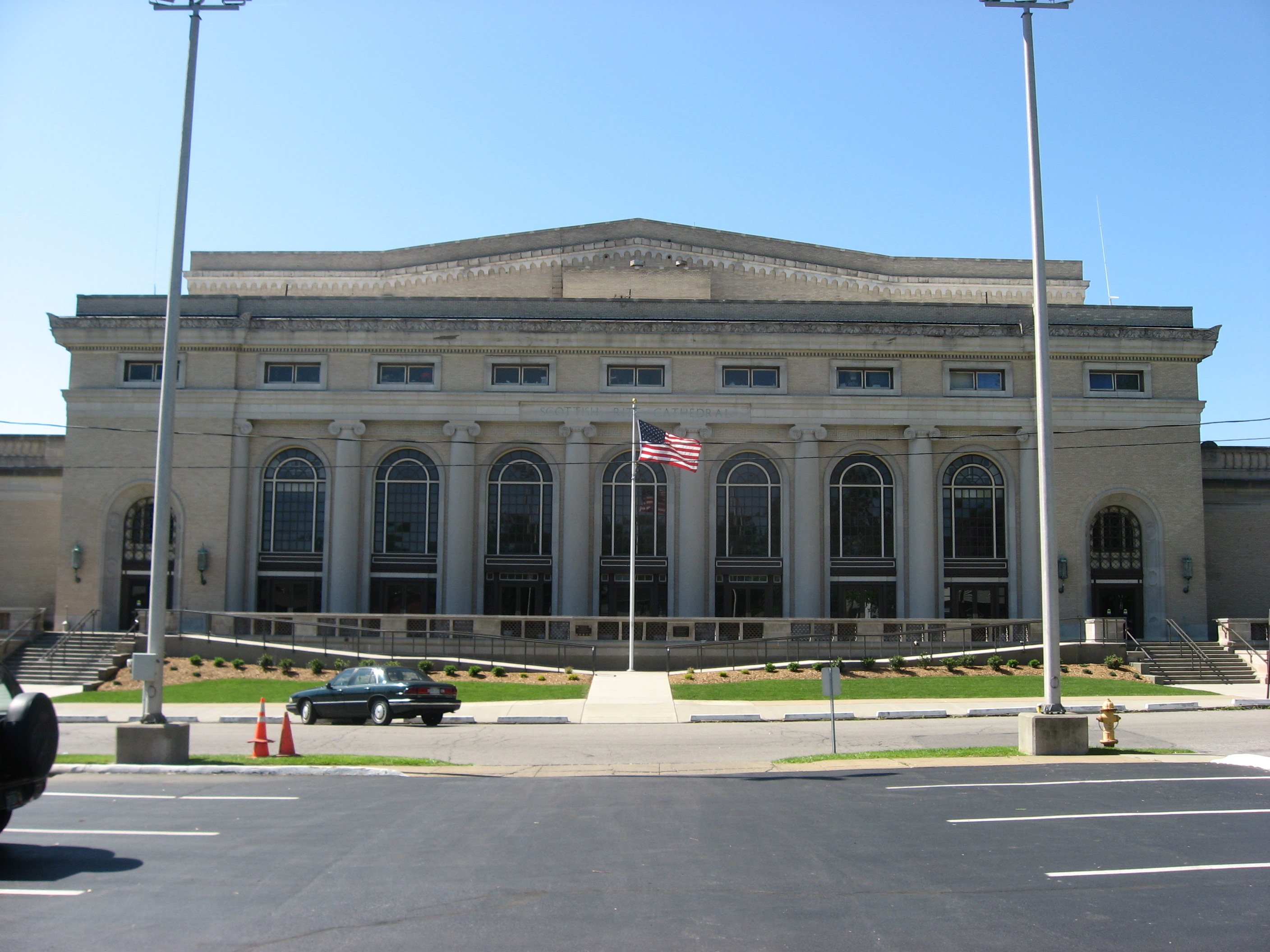
41°7′7″N 80°20′1″W / 41.11861°N 80.33361°WNew Wilmington 9 Scottish Rite Cathedral 
December 30, 2008 110 East Lincoln Avenue
41°0′19″N 80°20′41″W / 41.00528°N 80.34472°WNew Castle See also
- List of National Historic Landmarks in Pennsylvania
- National Register of Historic Places listings in Pennsylvania
- List of Pennsylvania state historical markers in Lawrence County
References
- ^ The latitude and longitude information provided in this table was derived originally from the National Register Information System, which has been found to be fairly accurate for about 99% of listings. For about 1% of NRIS original coordinates, experience has shown that one or both coordinates are typos or otherwise extremely far off; some corrections may have been made. A more subtle problem causes many locations to be off by up to 150 yards, depending on location in the country: most NRIS coordinates were derived from tracing out latitude and longitudes off of USGS topographical quadrant maps created under the North American Datum of 1927, which differs from the current, highly accurate WGS84 GPS system used by Google maps. Chicago is about right, but NRIS longitudes in Washington are higher by about 4.5 seconds, and are lower by about 2.0 seconds in Maine. Latitudes differ by about 1.0 second in Florida. Some locations in this table may have been corrected to current GPS standards.
- ^ "National Register of Historic Places: Weekly List Actions". National Park Service, United States Department of the Interior. Retrieved on November 10, 2011.
- ^ Numbers represent an ordering by significant words. Various colorings, defined here, differentiate National Historic Landmark sites and National Register of Historic Places Districts from other NRHP buildings, structures, sites or objects.
- ^ "NPS Focus". National Register of Historic Places. National Park Service. http://nrhp.focus.nps.gov. Retrieved November 20, 2009.
National Register of Historic Places in Lawrence County, Pennsylvania Historic district 
Other properties Banks Covered Bridge | Lawrence County Courthouse | McClelland Homestead | McConnell's Mill Covered Bridge | New Castle Armory | Old Homestead | S.R. Thompson House | Scottish Rite Cathedral
Owner objected to listing St. Mary's Roman Catholic Church | Wilroy Furnace
See also: National Register of Historic Places listings in Lawrence County, Pennsylvania and List of National Historic Landmarks in PennsylvaniaMunicipalities and communities of Lawrence County, Pennsylvania City 
Boroughs Bessemer | Ellport | Ellwood City‡ | Enon Valley | New Beaver | New Wilmington | S.N.P.J. | South New Castle | Volant | Wampum
Townships Hickory | Little Beaver | Mahoning | Neshannock | North Beaver | Perry | Plain Grove | Pulaski | Scott | Shenango | Slippery Rock | Taylor | Union | Washington | Wayne | Wilmington
CDPs Unincorporated
communitiesHarlansburg | Rose Point | West Pittsburg
Footnotes ‡This populated place also has portions in an adjacent county or counties
Categories:- Lawrence County, Pennsylvania
- National Register of Historic Places in Pennsylvania by county
-


Wikimedia Foundation. 2010.