- National Register of Historic Places listings in Laramie County, Wyoming
-
 Location of Laramie County in Wyoming
This is a list of the National Register of Historic Places listings in Laramie County, Wyoming. It is intended to be a complete list of the properties and districts on the National Register of Historic Places in Laramie County, Wyoming, United States. The locations of National Register properties and districts for which the latitude and longitude coordinates are included below, may be seen in a Google map.[1]
There are 52 properties and districts listed on the National Register in the county, 3 of which are National Historic Landmarks.
-
- This National Park Service list is complete through NPS recent listings posted November 10, 2011.[2]
Contents: Counties in Wyoming Albany - Big Horn - Campbell - Carbon - Converse - Crook - Fremont - Goshen - Hot Springs - Johnson - Laramie - Lincoln - Natrona - Niobrara - Park - Platte - Sheridan - Sublette - Sweetwater - Teton - Uinta - Washakie - Weston Current listings
[3] Landmark name Image Date listed Location City or town Summary 1 Atlas Theatre 
April 3, 1973 213 W. 16th St.
41°07′57″N 104°48′54″W / 41.1325°N 104.815°WCheyenne 2 Baxter Ranch Headquarters Buildings June 14, 1979 912-922 E. 18th St. and 1810-1920 Morris Ave.
41°08′20″N 104°48′19″W / 41.138889°N 104.805278°WCheyenne 3 Charles L. Beatty House June 28, 1990 2320 Capitol Ave.
41°08′21″N 104°49′10″W / 41.139167°N 104.819444°WCheyenne 4 Boeing/United Airlines Terminal Building, Hangar and Fountain 
February 7, 1985 200 E. 8th Ave.
41°09′13″N 104°49′13″W / 41.153611°N 104.820278°WCheyenne 5 Capitol North Historic District December 10, 1980 Roughly bounded by E. 29th and E. 25th Sts. and Warren and Pioneer Aves.
41°08′32″N 104°48′33″W / 41.142222°N 104.809167°WCheyenne 6 Castle on 19th Street July 10, 1979 1318 E. 19th St.
41°08′29″N 104°48′04″W / 41.141389°N 104.801111°WCheyenne 7 Cheyenne Flour Milling Company October 13, 2003 810-814 W. 23rd St.
41°08′11″N 104°49′35″W / 41.136389°N 104.826389°WCheyenne 8 Cheyenne High School 
August 22, 2005 2810 House Ave.
41°08′41″N 104°49′09″W / 41.144722°N 104.819167°WCheyenne 9 Cheyenne South Side Historic District October 11, 2006 Roughly bounded by Warren Ave., Russell Ave., E. 10th St., and E. 5th St.
41°07′38″N 104°48′13″W / 41.127222°N 104.803611°WCheyenne 10 Churchill Public School August 22, 2005 510 W. 29th St.
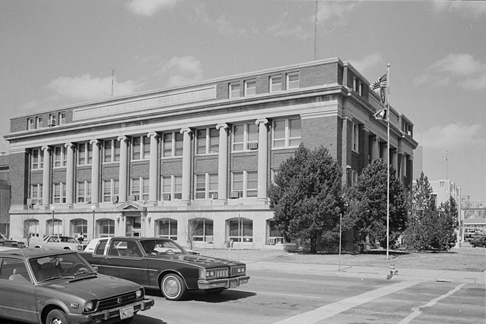
41°08′35″N 104°49′36″W / 41.143056°N 104.826667°WCheyenne 11 City and County Building 
November 30, 1978 19th St. and Carey Ave.
41°08′06″N 104°49′06″W / 41.135°N 104.818333°WCheyenne 12 Continental Oil Company 
October 13, 2003 801 W. 19th St.
41°07′57″N 104°49′24″W / 41.1325°N 104.823333°WCheyenne 13 Corlett School August 22, 2005 600 W. 22nd St.
41°08′12″N 104°49′25″W / 41.136667°N 104.823611°WCheyenne 14 Crook House July 10, 1979 314 E. 21st St.
41°08′20″N 104°48′50″W / 41.138889°N 104.813889°WCheyenne 15 Crow Creek-Cole Ranch Headquarters Historic District July 14, 2009 1065 Happy Jack Rd.
41°10′17″N 105°05′15″W / 41.171253°N 105.087411°WCheyenne 16 Deming School August 22, 2005 715 W. 5th Ave.
41°09′01″N 104°49′44″W / 41.150278°N 104.828889°WCheyenne 17 Dereemer Ranch Historic District November 25, 1983 East of Horse Creek
41°24′49″N 105°07′54″W / 41.413611°N 105.131667°WHorse Creek 18 Downtown Cheyenne Historic District 
December 22, 1978 Roughly bounded by 15th and 16th Sts. and Central and Pioneer Aves.; also roughly bounded by 17th and 18th Sts., Pioneer and Carey Aves., also along Central Ave. and 17th St.; also roughly bounded by 19th St., Capital Ave., 17th St., and Carey Ave.; also roughly bounded by 18th, Carey, 16th, and Warren Sts.
41°07′55″N 104°48′56″W / 41.131944°N 104.815556°WCheyenne Three boundary increases 19 Federal Office Building-Cheyenne October 12, 2000 308 W. 21st St.
41°08′13″N 104°49′09″W / 41.136944°N 104.819167°WCheyenne 20 Mabel Fincher School 
August 22, 2005 2201 Morrie Ave.
41°08′34″N 104°48′25″W / 41.142778°N 104.806944°WCheyenne 21 First United Methodist Church 
February 25, 1975 Northeastern corner of 18th St. and Central Ave.
41°08′07″N 104°48′53″W / 41.135278°N 104.814722°WCheyenne 22 Fort David A. Russell 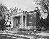
October 1, 1969 Western side of Cheyenne
41°09′10″N 104°51′27″W / 41.152778°N 104.8575°WCheyenne 23 Moreton Frewen House 
April 14, 1975 506 E. 23rd St.
41°08′29″N 104°48′46″W / 41.141389°N 104.812778°WCheyenne 24 Governor's Mansion 
September 30, 1969 300 E. 21st St.
41°08′13″N 104°48′53″W / 41.136944°N 104.814722°WCheyenne 25 Hebard Public School August 22, 2005 413 Seymour Ave.
41°07′32″N 104°47′59″W / 41.125556°N 104.799722°WCheyenne 26 Hynds Lodge March 23, 1984 Curt Gowdy State Park
41°11′46″N 105°15′21″W / 41.196111°N 105.255833°WCheyenne 27 Johnson Public School August 22, 2005 711 Warren Ave.
41°08′41″N 104°49′09″W / 41.144722°N 104.819167°WCheyenne 28 Keefe Row 
August 3, 1979 E. 22nd St. and Evans Ave
41°08′23″N 104°48′47″W / 41.139722°N 104.813056°WCheyenne 29 Ferdinand Lafrentz House July 17, 1979 2015 Warren Ave.
41°08′15″N 104°48′53″W / 41.1375°N 104.814722°WCheyenne 30 Lakeview Historic District 
August 5, 1996 Roughly bounded by 27th, Seymour, Maxwell, and Warren
41°08′31″N 104°48′52″W / 41.141944°N 104.814444°WCheyenne 31 Laramie County Milk Producers Cooperative Association October 13, 2003 1122 W. 23rd St.
41°08′13″N 104°49′31″W / 41.136944°N 104.825278°WCheyenne 32 Masonic Temple 
October 25, 1984 1820 Capitol Ave.
41°08′06″N 104°49′00″W / 41.135°N 104.816667°WCheyenne 33 McCord-Brady Company October 13, 2003 1506 Thomes Ave.
41°07′51″N 104°49′05″W / 41.130833°N 104.818056°WCheyenne 34 Lulu McCormick Junior High School August 22, 2005 2001 Capitol Ave.
41°08′13″N 104°49′01″W / 41.136944°N 104.816944°WCheyenne 35 McDonald Ranch May 14, 1987 14 miles southwest of Chugwater on the southern side of the Laramie County line
41°39′17″N 105°02′03″W / 41.654628°N 105.034256°WChugwater 36 Moore Haven Heights Historic District January 8, 2009 Between Bent Ave. on the west, the eastern side of Central Ave. on the east, W. 8th Ave. on the north, and W. Pershing Boulevard on the south
41°08′58″N 104°49′31″W / 41.14958°N 104.82532°WCheyenne 37 Nagle-Warren Mansion 
July 12, 1976 222 E. 17th St.
41°08′06″N 104°48′44″W / 41.135°N 104.812222°WCheyenne 38 Park Addition School August 22, 2005 1100 Richardson Court
41°08′34″N 104°49′59″W / 41.142778°N 104.833056°WCheyenne 39 Pine Bluffs High School March 21, 1996 Junction of 7th and Elm Sts.
41°10′41″N 104°03′56″W / 41.178056°N 104.065556°WPine Bluffs 40 Rainsford Historic District 
November 6, 1984 Roughly bounded by Morrie, 22nd, Warren, and 17th Sts.
41°08′20″N 104°48′38″W / 41.138889°N 104.810556°WCheyenne 41 Remount Ranch 
September 19, 1990 Remount Ranch Rd., 1 mile south of U.S. Route 80
41°05′24″N 105°14′30″W / 41.09°N 105.241667°WCheyenne 42 St. Mark's Episcopal Church 
February 26, 1970 1908 Central Ave.
41°08′09″N 104°48′57″W / 41.135833°N 104.815833°WCheyenne 43 St. Mary's Catholic Cathedral November 20, 1974 2107 Capitol Ave.
41°08′15″N 104°49′03″W / 41.1375°N 104.8175°WCheyenne 44 Storey Gymnasium August 22, 2005 2811 House Ave.
41°08′43″N 104°49′05″W / 41.145278°N 104.818056°WCheyenne 45 William Sturgis House November 8, 1982 821 E. 17th St.
41°08′14″N 104°48′20″W / 41.137222°N 104.805556°WCheyenne 46 Texas Oil Company October 13, 2003 1122 W. 23rd St.
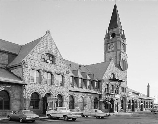
41°08′06″N 104°49′46″W / 41.135°N 104.829444°WCheyenne 47 Union Pacific Railroad Depot 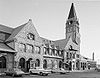
January 29, 1973 121 W. 15th St.
41°8′1″N 104°48′51″W / 41.13361°N 104.81417°WCheyenne 48 Union Pacific Roundhouse, Turntable and Machine Shop 
July 24, 1992 121 W. 15th St.
41°07′47″N 104°48′51″W / 41.129722°N 104.814167°WCheyenne 49 Van Tassell Carriage Barn September 13, 1978 1010 E. 16th St.
41°08′17″N 104°48′11″W / 41.138056°N 104.803056°WCheyenne 50 Whipple-Lacey House May 15, 1980 300 E. 17th St.
41°08′06″N 104°48′43″W / 41.135°N 104.811944°WCheyenne 51 Wyoming Fuel Company 
October 13, 2003 720 W. 18th St.
41°07′57″N 104°49′21″W / 41.1325°N 104.8225°WCheyenne 52 Wyoming State Capitol and Grounds 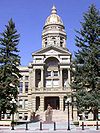
January 29, 1973 24th St. and Capitol Ave.
41°08′25″N 104°49′11″W / 41.140278°N 104.819722°WCheyenne See also
- List of National Historic Landmarks in Wyoming
- National Register of Historic Places listings in Wyoming
References
- ^ The latitude and longitude information provided in this table was derived originally from the National Register Information System, which has been found to be fairly accurate for about 99% of listings. For about 1% of NRIS original coordinates, experience has shown that one or both coordinates are typos or otherwise extremely far off; some corrections may have been made. A more subtle problem causes many locations to be off by up to 150 yards, depending on location in the country: most NRIS coordinates were derived from tracing out latitude and longitudes off of USGS topographical quadrant maps created under the North American Datum of 1927, which differs from the current, highly accurate WGS84 GPS system used by Google maps. Chicago is about right, but NRIS longitudes in Washington are higher by about 4.5 seconds, and are lower by about 2.0 seconds in Maine. Latitudes differ by about 1.0 second in Florida. Some locations in this table may have been corrected to current GPS standards.
- ^ "National Register of Historic Places: Weekly List Actions". National Park Service, United States Department of the Interior. Retrieved on November 10, 2011.
- ^ Numbers represent an ordering by significant words. Various colorings, defined here, differentiate National Historic Landmark sites and National Register of Historic Places Districts from other NRHP buildings, structures, sites or objects.
U.S. National Register of Historic Places Topics Lists by states Alabama • Alaska • Arizona • Arkansas • California • Colorado • Connecticut • Delaware • Florida • Georgia • Hawaii • Idaho • Illinois • Indiana • Iowa • Kansas • Kentucky • Louisiana • Maine • Maryland • Massachusetts • Michigan • Minnesota • Mississippi • Missouri • Montana • Nebraska • Nevada • New Hampshire • New Jersey • New Mexico • New York • North Carolina • North Dakota • Ohio • Oklahoma • Oregon • Pennsylvania • Rhode Island • South Carolina • South Dakota • Tennessee • Texas • Utah • Vermont • Virginia • Washington • West Virginia • Wisconsin • WyomingLists by territories Lists by associated states Other Municipalities and communities of Laramie County, Wyoming City 
Towns Albin | Burns | Pine Bluffs
CDPs Fox Farm-College | Ranchettes | South Greeley | Warren AFB
Unincorporated
communitiesCarpenter | Granite | Hillsdale | Horse Creek | Meriden
Categories:- National Register of Historic Places in Wyoming by county
- Laramie County, Wyoming
-


Wikimedia Foundation. 2010.