- National Register of Historic Places listings in Galveston County, Texas
-
List of Registered Historic Places in Galveston County, Texas
This is intended to be a complete list of properties and districts listed on the National Register of Historic Places in Galveston County, Texas. The locations of National Register properties and districts (at least for all showing latitude and longitude coordinates below) may be seen in a Google map by clicking on "Map of all coordinates".[1]
Greyed locations are places that have been removed from the Register.
-
- This National Park Service list is complete through NPS recent listings posted November 10, 2011.[2]
[3] Landmark name [4] Image Date listed Location City or town Summary 1 Ashbel Smith Building 
October 28, 1969 914-916 Ave. B
29°18′48″N 94°46′44″W / 29.313333°N 94.778889°WGalveston 2 Ashton Villa 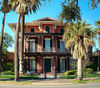
October 28, 1969 2328 Broadway
29°17′59″N 94°47′33″W / 29.299722°N 94.7925°WGalveston 3 Henry Beissner House April 3, 1978 2818 Ball Ave.
29°18′01″N 94°47′56″W / 29.300278°N 94.798889°WGalveston 4 Bishop's Palace 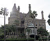
August 25, 1970 1402 Ave. J (Broadway)
29°18′17″N 94°46′55″W / 29.304722°N 94.781944°WGalveston 5 Building at 1921-1921 1/2 Avenue D August 14, 1984 1921-1921 1/2 Ave. D
29°18′21″N 94°47′23″W / 29.305833°N 94.789722°WGalveston 6 Building at 1925-1927 Market Street August 14, 1984 1925-1927 Market St.
29°18′25″N 94°47′29″W / 29.306944°N 94.791389°WGalveston 7 Cedar Lawn Historic District December 20, 2002 Bounded by 45th. St., 48th St., Ave. L, and Ave. N,
29°17′23″N 94°49′04″W / 29.289722°N 94.817778°WGalveston 8 City Hall 
August 14, 1984 823 25th St.
29°18′01″N 94°47′43″W / 29.300278°N 94.795278°WGalveston 9 City National Bank 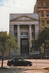
August 14, 1984 2219 Ave. D
29°18′18″N 94°47′36″W / 29.305°N 94.793333°WGalveston 10 Frank B. Davison House June 29, 1976 109 3rd Ave.
29°23′13″N 94°53′42″W / 29.386944°N 94.895°WTexas City 11 Denver Court Historic District January 14, 2002 Roughly bounded by Aves. S1/2 and U1/2, 43rd and 52nd Sts.
29°16′39″N 94°48′54″W / 29.2775°N 94.815°WGalveston 12 East End Historic District 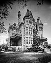
May 30, 1975 Irregular pattern including both sides of Broadway and Market Sts.
29°18′16″N 94°46′58″W / 29.304444°N 94.782778°WGalveston 13 Eiband's 
August 14, 1984 2001 Central Plaza
29°18′16″N 94°47′32″W / 29.304444°N 94.792222°WGalveston 14 Elissa 
March 21, 1978 Seawolf Park
29°20′05″N 94°46′39″W / 29.334722°N 94.7775°WGalveston 15 First Evangelical Lutheran Church August 14, 1984 2401 Ave. G
29°18′07″N 94°47′39″W / 29.301944°N 94.794167°WGalveston 16 First Presbyterian Church January 29, 1979 1903 Church St.
29°18′15″N 94°47′19″W / 29.304167°N 94.788611°WGalveston 17 Fort Travis March 30, 2005 TX 87 at Loop 108
29°21′53″N 94°45′29″W / 29.364722°N 94.758056°WPort Bolivar 18 Galveston Causeway 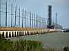
December 12, 1976 Spans Galveston Bay from Virginia Point to Galveston Island
29°17′51″N 94°53′12″W / 29.2975°N 94.886667°WGalveston 19 Galveston Orphans Home March 21, 1979 1315 21st St.
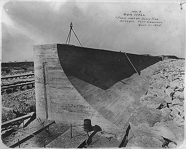
29°17′50″N 94°47′19″W / 29.297222°N 94.788611°WGalveston 20 Galveston Seawall 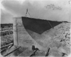
August 18, 1977 Seawall Blvd.
29°18′09″N 94°46′27″W / 29.3025°N 94.774167°WGalveston 21 Galveston US Post Office, Custom House and Courthouse 
April 25, 2001 25th St. and F Ave.
29°18′08″N 94°47′45″W / 29.302222°N 94.795833°WGalveston 22 Galvez Hotel 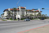
April 4, 1979 2024 Seawall Blvd.
29°17′32″N 94°47′08″W / 29.292222°N 94.785556°WGalveston 23 Garten Verein Pavilion July 20, 1977 27th St. and Avenue O (Kempner Park)
29°17′34″N 94°47′41″W / 29.292778°N 94.794722°WGalveston 24 Grace Episcopal Church 
April 3, 1975 1115 36th St.
29°17′39″N 94°48′23″W / 29.294167°N 94.806389°WGalveston 25 Grand Opera House 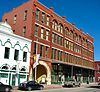
January 2, 1974 2012-2020 Ave. E
29°17′47″N 94°47′26″W / 29.296389°N 94.790556°WGalveston 26 John Hagemann House June 1, 1982 3301 Ave. L
29°17′40″N 94°48′47″W / 29.294444°N 94.813056°WGalveston 27 House at 2017-2023 Avenue I August 14, 1984 2017-2023 Ave. I
29°18′05″N 94°47′07″W / 29.301389°N 94.785278°WGalveston 28 House at 2528 Postoffice St. August 14, 1984 2528 Postoffice St.
29°18′13″N 94°47′49″W / 29.303611°N 94.796944°WGalveston 29 Sealy Hutchings House July 29, 1994 2805 Ave. O
29°17′31″N 94°47′44″W / 29.291944°N 94.795556°WGalveston 30 I.O.O.F. Lodge August 14, 1984 505 20th St.
29°18′18″N 94°47′24″W / 29.305°N 94.79°WGalveston 31 Illies Building-Justine Apartments August 22, 1995 503 21st St.
29°17′49″N 94°46′56″W / 29.296944°N 94.782222°WGalveston 32 Jean Lafitte Hotel August 14, 1984 2105 Ave. F
29°18′14″N 94°47′27″W / 29.303889°N 94.790833°WGalveston 33 Daniel Webster Kempner House March 30, 1979 2504 Ave. O
29°17′35″N 94°47′34″W / 29.293056°N 94.792778°WGalveston 34 Lasker Home for Homeless Children April 14, 1983 1019 16th St.
29°18′02″N 94°47′01″W / 29.300556°N 94.783611°WGalveston 35 E.S. Levy Building November 13, 2003 2221-2225 Market St.
29°18′17″N 94°47′36″W / 29.304722°N 94.793333°WGalveston 36 Marschner Building August 14, 1984 1914-1916 Mechanic St.
29°18′26″N 94°47′23″W / 29.307222°N 94.789722°WGalveston 37 McKinney-McDonald House May 4, 1976 926 Winnie St.
29°18′24″N 94°46′39″W / 29.306667°N 94.7775°WGalveston 38 Melrose Apartment Building October 14, 1998 2002 Post Office St.
29°18′19″N 94°47′26″W / 29.305278°N 94.790556°WGalveston 39 Michel B. Menard House December 12, 1976 1605 33rd St.
29°17′27″N 94°48′06″W / 29.290833°N 94.801667°WGalveston 40 Merimax Building January 24, 1985 521 22nd St.
29°18′47″N 94°46′56″W / 29.313056°N 94.782222°WGalveston 41 Model Laundry August 14, 1984 513-523 25th St.
29°18′10″N 94°47′45″W / 29.302778°N 94.795833°WGalveston 42 Col. Hugh B. and Helen Moore House October 28, 1994 8 Ninth Ave., N.
29°23′38″N 94°54′10″W / 29.393889°N 94.902778°WTexas City 43 Mosquito Fleet Berth, Pier 19 April 21, 1975 N end of 20th St., Pier 19
29°18′39″N 94°47′25″W / 29.310833°N 94.790278°WGalveston 44 Old Galveston Customhouse 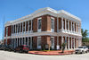
August 25, 1970 SE corner 20th and Post Office (Ave. E) Sts.
29°18′18″N 94°47′23″W / 29.305°N 94.789722°WGalveston 45 Pix Building August 14, 1984 2128 Postoffice St.
29°18′18″N 94°47′32″W / 29.305°N 94.792222°WGalveston 46 Point Bolivar Lighthouse 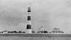
August 18, 1977 TX 87
29°22′00″N 94°46′00″W / 29.366667°N 94.766667°WPort Bolivar 47 Powhatan House October 6, 1975 3427 Ave. O
29°17′24″N 94°48′11″W / 29.29°N 94.803056°WGalveston 48 Reedy Chapel-AME Church September 14, 1984 2013 Broadway
29°18′00″N 94°47′19″W / 29.3°N 94.788611°WGalveston 49 Robinson Building August 14, 1984 2009-2011 Postoffice St.
29°18′17″N 94°47′26″W / 29.304722°N 94.790556°WGalveston 50 Rosenberg Library 
August 14, 1984 2310 Sealy St.
29°18′03″N 94°47′34″W / 29.300833°N 94.792778°WGalveston 51 Scottish Rite Cathedral August 14, 1984 2128 Church St.
29°18′14″N 94°47′30″W / 29.303889°N 94.791667°WGalveston 52 George Sealy House October 28, 1969 2424 Broadway
29°17′59″N 94°47′37″W / 29.299722°N 94.793611°WGalveston 53 The Settlement Historic District May 17, 2010 Centered on the intersection of N Bell Dr and the 100 block of S Bell Dr with cross-streets Carver Ave and Eunice St
29°22′58″N 94°58′38″W / 29.382778°N 94.977222°WTexas City 54 M. W. Shaw Building August 14, 1984 2427 Ave. D
29°18′16″N 94°47′45″W / 29.304444°N 94.795833°WGalveston 55 Silk Stocking Residential Historic District May 10, 1996 Roughly bounded by Ave. K, 23rd St., Ave. P, and 26th St.
29°17′42″N 94°47′30″W / 29.295°N 94.791667°WGalveston 56 SS Selma (steamship) January 5, 1994 Address Restricted Galveston 57 St. Joseph's Church 
December 12, 1976 2202 Ave. K
29°17′57″N 94°47′26″W / 29.299167°N 94.790556°WGalveston 58 St. Mary's Cathedral 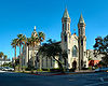
June 4, 1973 2011 Church Ave.
29°18′14″N 94°47′24″W / 29.303889°N 94.79°WGalveston 59 Star Drug Store August 14, 1984 510 23rd St.
29°18′14″N 94°47′35″W / 29.303889°N 94.793056°WGalveston 60 Steffens-Drewa House Complex December 1, 1988 2701, 2705, and 2709 Ave. O
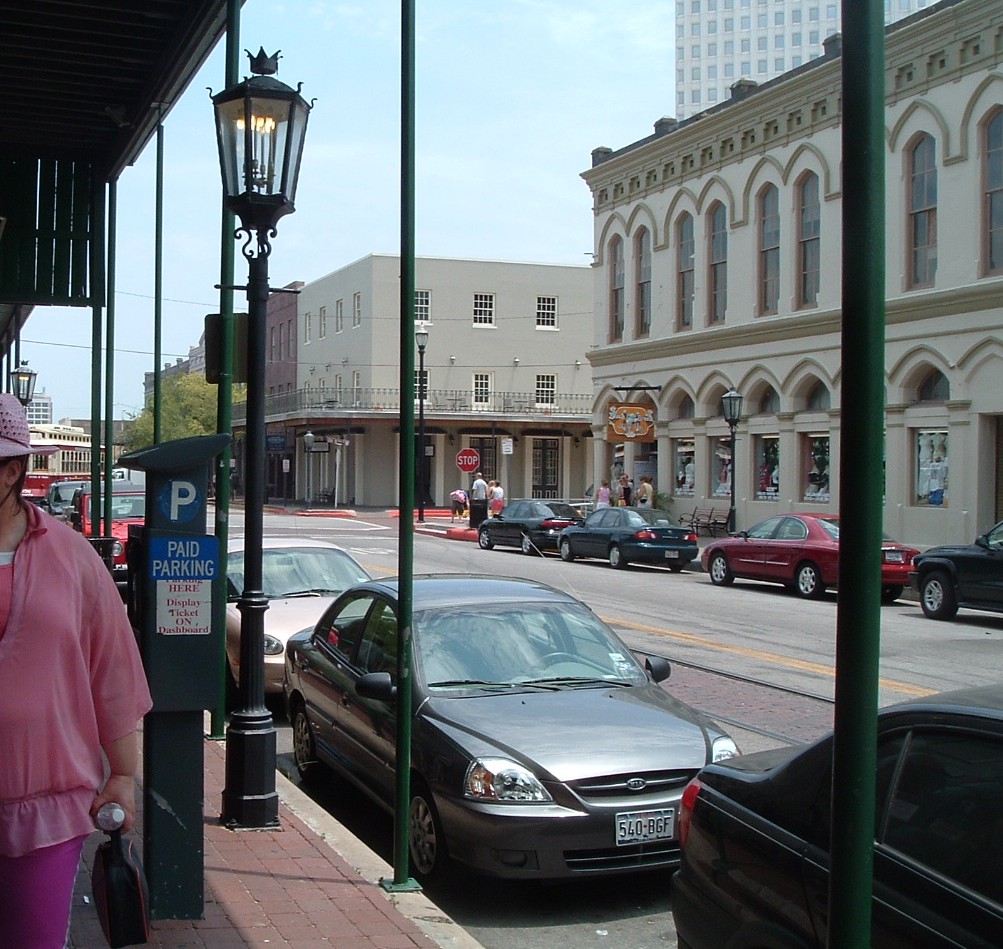
29°17′32″N 94°47′40″W / 29.292222°N 94.794444°WGalveston 61 The Strand Historic District 
January 26, 1970 Roughly bounded by Ave. A, 20th St., alley between Aves. C and D, and railroad depot
29°18′23″N 94°47′37″W / 29.306389°N 94.793611°WGalveston 62 Sweeney-Royston House September 1, 1978 2402 Ave. L
29°17′52″N 94°47′32″W / 29.297778°N 94.792222°WGalveston 63 Texas Building August 14, 1984 2200 Central Plaza
29°18′17″N 94°47′33″W / 29.304722°N 94.7925°WGalveston 64 Texas Heroes Monument August 14, 1984 25th and Broadway
29°17′57″N 94°47′39″W / 29.299167°N 94.794167°WGalveston 65 Trinity Protestant Episcopal Church September 4, 1979 22nd St. and Ave. G
29°18′08″N 94°47′31″W / 29.302222°N 94.791944°WGalveston 66 Trueheart-Adriance Building July 14, 1971 212 22nd St.
29°18′24″N 94°47′33″W / 29.306667°N 94.7925°WGalveston 67 U.S. National Bank 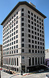
August 14, 1984 2201 Ave. D
29°18′19″N 94°47′34″W / 29.305278°N 94.792778°WGalveston 68 USS Cavalla (submarine) 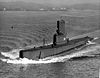
May 27, 2008 East End of Seawolf Park
29°20′09″N 94°46′46″W / 29.335833°N 94.779444°WGalveston 69 USS Hatteras (1861) January 28, 1977 Address Restricted Galveston 70 USS Stewart 
July 12, 2007 East End of Seawolf Park
29°20′09″N 94°46′46″W / 29.335833°N 94.779444°WGalveston 71 Samuel May Williams House July 14, 1971 361 Ave. P
29°17′16″N 94°48′15″W / 29.287778°N 94.804167°WGalveston 72 Willis-Moody Mansion May 13, 1994 2618 Broadway
29°17′57″N 94°47′46″W / 29.299167°N 94.796111°WGalveston Former listings
[3] Landmark name Image Date listed Location City or town Summary 1 Balinese Room 
January 8, 2009 2107 Seawall Blvd.
29°17′23″N 94°47′7″W / 29.28972°N 94.78528°WGalveston Originally listed April 2, 1997. Destroyed by Hurricane Ike September 13, 2008; removed from NRHP January 8, 2009[5] 2 The Breakers January 8, 2009 TX 87 W. of Gilchrist
29°29′47″N 94°31′44″W / 29.49639°N 94.52889°WCaplen Listed October 10, 1998. Destroyed by Hurricane Ike 9/13/2008[6]; removed from NRHP January 8, 2009[5] 3 Moser House January 8, 2009 509 19th St.
29°18′18″N 94°47′21″W / 29.305°N 94.78917°WGalveston Listed August 14, 1984. Removed from NRHP January 8, 2009[5] See also
- Registered Historic Places in Texas, Counties D-G
References
- ^ The latitude and longitude information provided in this table was derived originally from the National Register Information System, which has been found to be fairly accurate for about 99% of listings. For about 1% of NRIS original coordinates, experience has shown that one or both coordinates are typos or otherwise extremely far off; some corrections may have been made. A more subtle problem causes many locations to be off by up to 150 yards, depending on location in the country: most NRIS coordinates were derived from tracing out latitude and longitudes off of USGS topographical quadrant maps created under North American Datum of 1927, which differs from the current, highly accurate GPS system used by Google maps. Chicago is about right, but NRIS longitudes in Washington are higher by about 4.5 seconds, and are lower by about 2.0 seconds in Maine. Latitudes differ by about 1.0 second in Florida. Some locations in this table may have been corrected to current GPS standards.
- ^ "National Register of Historic Places: Weekly List Actions". National Park Service, United States Department of the Interior. Retrieved on November 10, 2011.
- ^ a b Numbers represent an ordering by significant words. Various colorings, defined here, differentiate National Historic Landmark sites and National Register of Historic Places Districts from other NRHP buildings, structures, sites or objects.
- ^ "National Register Information System". National Register of Historic Places. National Park Service. . http://nrhp.focus.nps.gov/natreg/docs/All_Data.html.
- ^ a b c "National Register of Historic Places Listings: January 16, 2009". U.S. National Park Service. http://www.nps.gov/nr/listings/20090116.HTM. Retrieved January 17, 2009.
- ^ http://beaumontenterprise.mycapture.com/mycapture/photos/FImage.aspx?ImageID=377033&EventID=561738&CategoryID=34376&CollectionID=0
U.S. National Register of Historic Places Topics Lists by states Alabama • Alaska • Arizona • Arkansas • California • Colorado • Connecticut • Delaware • Florida • Georgia • Hawaii • Idaho • Illinois • Indiana • Iowa • Kansas • Kentucky • Louisiana • Maine • Maryland • Massachusetts • Michigan • Minnesota • Mississippi • Missouri • Montana • Nebraska • Nevada • New Hampshire • New Jersey • New Mexico • New York • North Carolina • North Dakota • Ohio • Oklahoma • Oregon • Pennsylvania • Rhode Island • South Carolina • South Dakota • Tennessee • Texas • Utah • Vermont • Virginia • Washington • West Virginia • Wisconsin • WyomingLists by territories Lists by associated states Other  Category:National Register of Historic Places •
  Portal:National Register of Historic PlacesCategories:
- Galveston County, Texas
- National Register of Historic Places in Texas
- Buildings and structures in Galveston County, Texas
-


Wikimedia Foundation. 2010.