- National Register of Historic Places listings in DeKalb County, Indiana
-
 Location of DeKalb County in Indiana
This is a list of the National Register of Historic Places listings in De Kalb County, Indiana.
This is intended to be a complete list of the properties and districts on National Register of Historic Places in De Kalb County, Indiana, United States. Latitude and longitude coordinates are provided for many National Register properties and districts; these locations may be seen together in a Google map.[1]
There are 25 properties and districts listed on the National Register in the county, including 1 National Historic Landmark.
-
- This National Park Service list is complete through NPS recent listings posted November 10, 2011.[2]
Current listings
[3] Landmark name [4] Image Date listed Location City or town Summary 1 Auburn Cord Duesenberg Automobile Facility 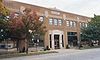
September 21, 1978 1600 S. Wayne St.
41°21′21″N 85°03′26″W / 41.355833°N 85.057222°WAuburn 2 Samuel Bevier House May 6, 1983 County Roads 11 and 52
41°20′13″N 85°08′15″W / 41.336944°N 85.1375°WGarrett 3 Joseph Bowman Farmhouse May 6, 1983 County Roads 19 and 40
41°22′52″N 85°05′55″W / 41.381111°N 85.098611°WGarrett 4 Breechbill-Davidson House May 6, 1983 State Road 8 and County Road 7
41°22′01″N 85°09′21″W / 41.366944°N 85.155833°WGarrett 5 Brethren in Christ Church May 6, 1983 County Road 7
41°22′12″N 85°09′18″W / 41.37°N 85.155°WGarrett 6 Orin Clark House May 6, 1983 County Roads 3 and 48
41°21′03″N 85°10′34″W / 41.350833°N 85.176111°WGarrett 7 William Cornell Homestead August 14, 1973 Southwest of Auburn off State Road 427
41°16′44″N 85°05′28″W / 41.278889°N 85.091111°WAuburn 8 DeKalb County Home and Barn May 6, 1983 County Road 40
41°22′50″N 85°04′59″W / 41.380556°N 85.083056°WGarrett 9 Downtown Auburn Historic District 
September 10, 1986 Roughly bounded by E. and W. 4th, N. and S. Cedar, E. 12th, and N. and S. Jackson Sts.
41°22′00″N 85°04′46″W / 41.366667°N 85.079444°WAuburn 10 Downtown Butler Historic District 
December 7, 2001 Roughly the 100 and 200 blocks of S. Broadway
41°25′11″N 84°52′29″W / 41.419722°N 84.874722°WButler 11 Eckhart Public Library and Park 
November 20, 1981 603 S. Jackson St.
41°21′50″N 85°03′27″W / 41.363889°N 85.0575°WAuburn 12 William Fountain House May 6, 1983 State Road 8
41°21′58″N 85°10′38″W / 41.366111°N 85.177222°WGarrett 13 Garrett Historic District May 6, 1983 Roughly bounded by Railroad, Britton, Warfield, and Hamsher Sts., and 3rd Ave.
41°20′43″N 85°08′06″W / 41.345278°N 85.135°WGarrett 14 Gump House May 6, 1983 State Road 8
41°21′58″N 85°11′23″W / 41.366111°N 85.189722°WGarrett 15 J.H. Haag House May 6, 1983 County Road 54
41°19′46″N 85°08′07″W / 41.329444°N 85.135278°WGarrett 16 Edward Kelham House May 6, 1983 County Road 48
41°21′07″N 85°11′20″W / 41.351944°N 85.188889°WGarrett 17 Keyser Township School 8 May 6, 1983 E. Quincy St.
41°21′06″N 85°07′03″W / 41.351667°N 85.1175°WGarrett 18 Charles Lehmback Farmstead May 6, 1983 County Road 15
41°20′36″N 85°07′01″W / 41.343333°N 85.116944°WGarrett 19 Mountz House September 11, 1979 507 E. Houston St.
41°20′53″N 85°07′49″W / 41.348056°N 85.130278°WGarrett 20 Henry Peters House May 6, 1983 201 N. 6th St.
41°21′06″N 85°07′11″W / 41.351667°N 85.119722°WGarrett 21 Rakestraw House May 6, 1983 County Road 19
41°22′11″N 85°05′54″W / 41.369722°N 85.098333°WGarrett 22 Henry Shull Farmhouse Inn May 6, 1983 County Road 11-A
41°19′36″N 85°05′23″W / 41.326667°N 85.089722°WGarrett 23 Spencerville Covered Bridge 
April 2, 1981 County Road 68
41°16′53″N 84°54′51″W / 41.281389°N 84.914167°WSpencerville 24 John Wilderson House May 6, 1983 1349 S. Cowen St.
41°20′04″N 85°08′12″W / 41.334444°N 85.136667°WGarrett 25 Maria and Franklin Wiltrout Polygonal Barn April 2, 1993 0209 County Road 16
41°28′03″N 85°11′02″W / 41.4675°N 85.183889°WCorunna See also
- List of National Historic Landmarks in Indiana
- National Register of Historic Places listings in Indiana
References
- ^ The latitude and longitude information provided in this table was derived originally from the National Register Information System, which has been found to be fairly accurate for about 99% of listings. For about 1% of NRIS original coordinates, experience has shown that one or both coordinates are typos or otherwise extremely far off; some corrections may have been made. A more subtle problem causes many locations to be off by up to 150 yards, depending on location in the country: most NRIS coordinates were derived from tracing out latitude and longitudes off of USGS topographical quadrant maps created under the North American Datum of 1927, which differs from the current, highly accurate WGS84 GPS system used by Google maps. Chicago is about right, but NRIS longitudes in Washington are higher by about 4.5 seconds, and are lower by about 2.0 seconds in Maine. Latitudes differ by about 1.0 second in Florida. Some locations in this table may have been corrected to current GPS standards.
- ^ "National Register of Historic Places: Weekly List Actions". National Park Service, United States Department of the Interior. Retrieved on November 10, 2011.
- ^ Numbers represent an ordering by significant words. Various colorings, defined here, differentiate National Historic Landmark sites and National Register of Historic Places Districts from other NRHP buildings, structures, sites or objects.
- ^ "National Register Information System". National Register of Historic Places. National Park Service. . http://nrhp.focus.nps.gov/natreg/docs/All_Data.html.
U.S. National Register of Historic Places Topics Lists by states Alabama • Alaska • Arizona • Arkansas • California • Colorado • Connecticut • Delaware • Florida • Georgia • Hawaii • Idaho • Illinois • Indiana • Iowa • Kansas • Kentucky • Louisiana • Maine • Maryland • Massachusetts • Michigan • Minnesota • Mississippi • Missouri • Montana • Nebraska • Nevada • New Hampshire • New Jersey • New Mexico • New York • North Carolina • North Dakota • Ohio • Oklahoma • Oregon • Pennsylvania • Rhode Island • South Carolina • South Dakota • Tennessee • Texas • Utah • Vermont • Virginia • Washington • West Virginia • Wisconsin • WyomingLists by territories Lists by associated states Other Municipalities and communities of DeKalb County, Indiana Cities 
Towns Townships Unincorporated
communitiesArtic | Auburn Junction | Butler Center | Cedar | Concord | Fairfield Center | Hopewell | Moore | New Era | Newville | Orangeville | Saint Johns | Sedan | Spencerville | Stafford Center | Summit | Taylor Corner
Footnotes ‡This populated place also has portions in an adjacent county or counties
Categories:- DeKalb County, Indiana
- National Register of Historic Places in Indiana by county
-


Wikimedia Foundation. 2010.