- National Register of Historic Places listings in Dallas County, Texas
-
List of Registered Historic Places in Dallas County, Texas
This is intended to be a complete list of properties and districts listed on the National Register of Historic Places in Dallas County, Texas. The locations of National Register properties and districts (at least for all showing latitude and longitude coordinates below) may be seen in a Google map by clicking on "Map of all coordinates".[1]
-
- This National Park Service list is complete through NPS recent listings posted November 10, 2011.[2]
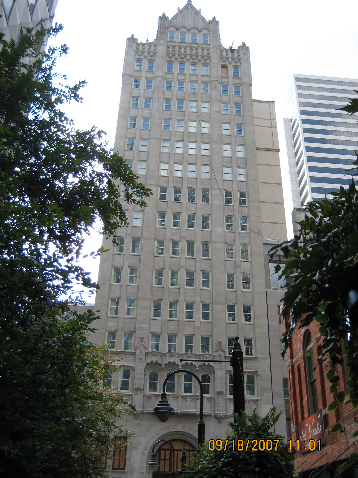
[3] Landmark name [4] Image Date listed Location City or town Summary 1 1926 Republic National Bank 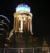
January 18, 2006 1309 Main St.
32°46′56″N 96°48′03″W / 32.782222°N 96.800833°WDallas 2 4928 Bryan Street Apartments March 23, 1995 4928 Bryan Street
32°48′16″N 96°46′20″W / 32.804444°N 96.772222°WDallas 3 W.H. Adamson High School 
June 8, 2011 201 E. 9th St.
32°44′52″N 96°49′19″W / 32.747778°N 96.821944°WDallas 4 Alcalde Street-Crockett School Historic District March 23, 1995 200-500 Alcalde, 421-421A N. Carroll and 4315 Victor
32°47′33″N 96°46′12″W / 32.7925°N 96.77°WDallas 5 D. M. Angle House March 27, 1985 800 Beltline
32°35′22″N 96°57′30″W / 32.589444°N 96.958333°WCedar Hill 6 Alfred Horatio Belo House 
October 29, 1975 2115 Ross Ave.
32°47′17″N 96°47′52″W / 32.788056°N 96.797778°WDallas 7 Didaco and Ida Bianchi House March 23, 1995 4503 Reiger Ave.
32°47′35″N 96°46′07″W / 32.793056°N 96.768611°WDallas 8 Bluitt Sanitarium July 26, 2006 2036 Commerce St.
32°46′58″N 96°47′33″W / 32.782778°N 96.7925°WDallas 9 Building at 3525 Turtle Creek Boulevard May 29, 2008 3525 Turtle Creek Boulevard
32°48′40″N 96°48′11″W / 32.811111°N 96.803056°WDallas 10 Bryan-Peak Commercial Historic District March 23, 1995 4214-4311 Bryan Ave. and 1325-1408 N. Peak
32°47′51″N 96°46′45″W / 32.7975°N 96.779167°WDallas 11 William Bryant Jr. House March 27, 1985 S. Broad and Cooper
32°35′09″N 96°57′25″W / 32.585833°N 96.956944°WCedar Hill 12 Busch Building 
July 4, 1980 1501-1509 Main St.
32°46′49″N 96°47′56″W / 32.780278°N 96.798889°WDallas Boundary increase (listed September 12, 1996): Busch-Kirby Building 13 Cedar Springs Place December 30, 1991 2531 Lucas Dr.
32°48′50″N 96°49′14″W / 32.813889°N 96.820556°WDallas 14 Central Congregational Church March 23, 1995 1530 N. Carroll
32°48′07″N 96°46′43″W / 32.801944°N 96.778611°WDallas 15 Chevrolet Motor Company Building April 18, 2003 3221 Commerce
32°47′04″N 96°46′36″W / 32.784444°N 96.776667°WDallas 16 Claremont Apartments March 23, 1995 4636 Ross Ave.
32°48′17″N 96°46′37″W / 32.804722°N 96.776944°WDallas 17 Clements Hall September 27, 1980 3200 Dyer St.
32°50′36″N 96°47′03″W / 32.843333°N 96.784167°WDallas 18 Colonial Hill Historic District March 23, 1995 Bounded by Pennsylvania Ave., I-45, US 75 and Hatcher
32°45′04″N 96°45′58″W / 32.751111°N 96.766111°WDallas 19 Continental Gin Company February 14, 1983 3301-3333 Elm St., 212 and 232 Trunk Ave.
32°47′10″N 96°46′37″W / 32.786111°N 96.776944°WDallas 20 Dallas County Courthouse 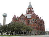
December 12, 1976 Houston and Commerce Sts.
32°46′45″N 96°48′25″W / 32.779167°N 96.806944°WDallas Also known as "Old Red Courthouse". Now Old Red Museum. 21 Dallas Downtown Historic District 
August 11, 2006 Roughly bounded by Federal, N. St. Paul, Pacific, Harwood, S. Pearl, Commerce, S Ervay, Akard, Commerce and Field
32°46′57″N 96°47′51″W / 32.782608°N 96.7975°WDallas Boundary increase (listed January 9, 2009): Bounded by Jackson, North Hardwood Commerice, N.-S. line between S. Pearl Exwy., and S. Hardwood Canton 22 Dallas Fire Station No. 16 April 17, 1997 5501 Columbia Ave.
32°47′56″N 96°45′18″W / 32.798889°N 96.755°WDallas 23 Dallas Hall November 17, 1978 Southern Methodist University campus
32°50′42″N 96°47′05″W / 32.845°N 96.784722°WDallas 24 Dallas High School Historic District February 20, 1996 2218 Bryan St.
32°47′10″N 96°47′36″W / 32.786111°N 96.793333°WDallas 25 Dallas National Bank 
May 10, 2005 1530 Main and 1511 Commerce St.
32°46′56″N 96°47′54″W / 32.782222°N 96.798333°WDallas 26 Dallas Scottish Rite Temple March 26, 1980 Harwood and Young Sts.
32°46′43″N 96°47′31″W / 32.778611°N 96.791944°WDallas 27 Dallas Tent and Awning Building October 28, 1999 3401 Commerce St.
32°47′06″N 96°46′28″W / 32.785°N 96.774444°WDallas 28 Dallas Times Herald Pasadena Perfect Home September 13, 2006 6938 Wildgrove Ave.
32°49′08″N 96°44′15″W / 32.818889°N 96.7375°WDallas 29 Dallas Union Terminal 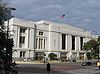
May 29, 1975 400 S. Houston St.
32°46′32″N 96°48′27″W / 32.775556°N 96.8075°WDallas 30 Dealey Plaza Historic District 
April 19, 1993 Roughly bounded by Pacific Ave., Market St., Jackson St. and right of way of Dallas Right of Way Management Company
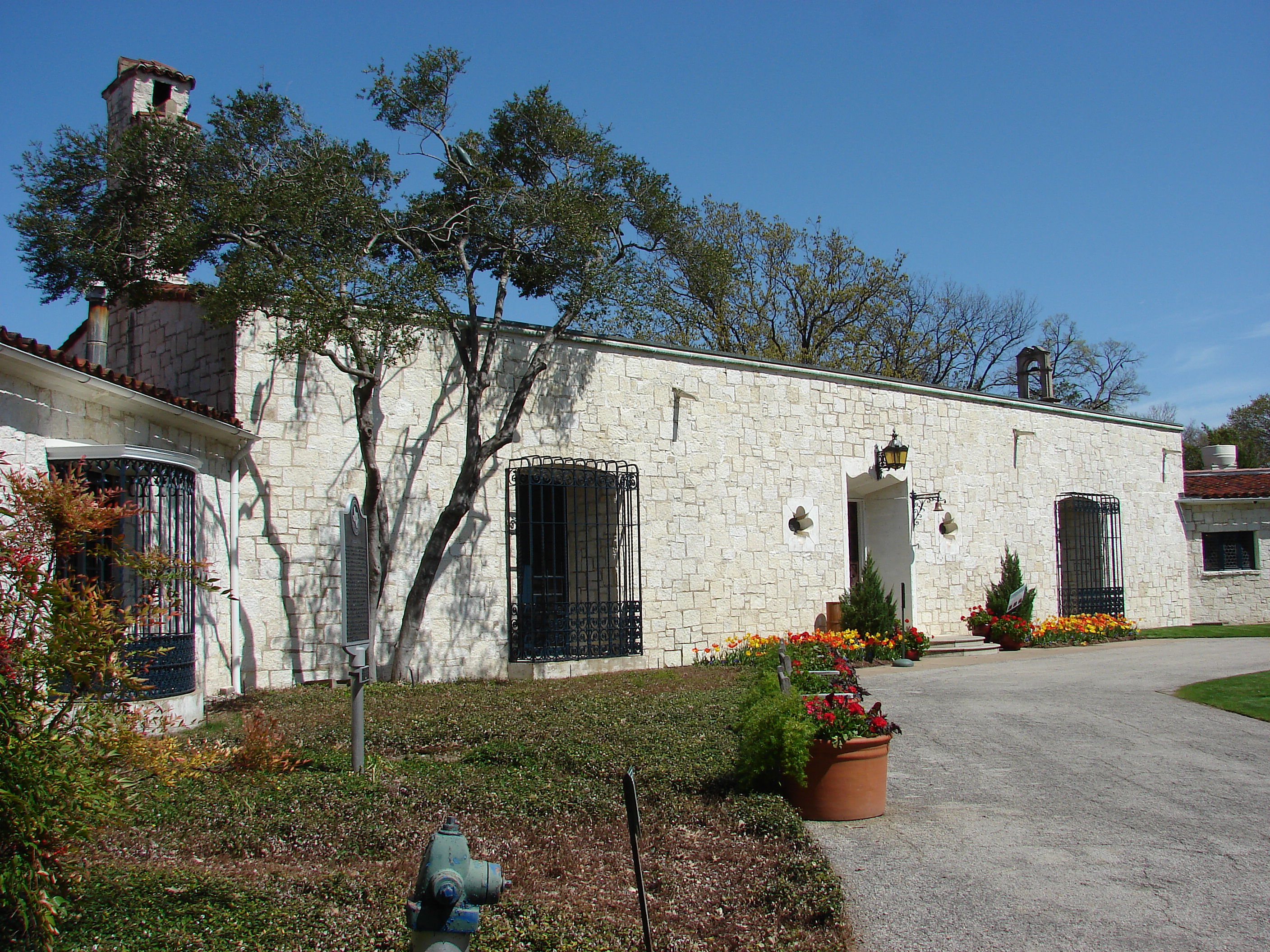
32°46′42″N 96°48′26″W / 32.778333°N 96.807222°WDallas 31 DeGolyer Estate 
December 28, 1978 8525 Garland Rd.
32°49′17″N 96°43′03″W / 32.821389°N 96.7175°WDallas 32 Dixon-Moore House March 23, 1995 2716 Peabody
32°48′07″N 96°46′43″W / 32.801944°N 96.778611°WDallas 33 James H. and Molly Ellis House March 23, 1995 2426 Pine
32°45′17″N 96°45′42″W / 32.754722°N 96.761667°WDallas 34 Emmanuel Lutheran Church (Dallas, Texas) March 23, 1995 4301 San Jacinto
32°48′02″N 96°46′51″W / 32.800556°N 96.780833°WDallas 35 James W. Fannin Elementary School March 23, 1995 4800 Ross Ave.
32°48′19″N 96°46′32″W / 32.805278°N 96.775556°WDallas 36 Fidelity Union Life Insurance Building 
September 29, 2009 1511 Bryan and 1507 Pacific Ave.
32°46′57″N 96°47′59″W / 32.7825°N 96.799722°WDallas 37 Fred Florence Hall September 27, 1980 3330 University Blvd.
32°50′43″N 96°47′10″W / 32.845278°N 96.786111°WDallas 38 Old Forest Avenue High School March 23, 1995 3000 Martin Luther King, Jr., Blvd.
32°46′16″N 96°45′53″W / 32.771111°N 96.764722°WDallas 39 G & J Manufacturing September 14, 2002 3912 Willow St.
32°47′08″N 96°46′13″W / 32.785556°N 96.770278°WDallas 40 Samuel and Julia Gilbert House November 10, 1988 2540 Farmers Branch Ln.
32°55′05″N 96°53′26″W / 32.918056°N 96.890556°WFarmers Branch 41 Goodyear Tire and Rubber Company Building and B.F. Goodrich Building February 19, 2002 2809 Parry Ave. and 4136-40 Commerce St.
32°46′29″N 96°45′56″W / 32.774722°N 96.765556°WDallas 42 Grace Methodist Episcopal Church November 4, 1982 4105 Junius St.
32°47′36″N 96°46′32″W / 32.793333°N 96.775556°WDallas 43 Greenway Parks Historic District January 10, 2008 Bounded by W. Mockingbird Ln., W. University Blvd., Inwood & N. Dallas Tollway. Dallas 44 George C. Greer House January 9, 1997 5439 Swiss Ave.
32°48′23″N 96°45′53″W / 32.806389°N 96.764722°WDallas 45 Gulf Oil Distribution Facility March 31, 2010 501 S. 2nd St.
32°46′56″N 96°46′22″W / 32.782222°N 96.772778°WDallas 46 Harlan Building February 26, 2004 2018 Cadiz St.
32°46′49″N 96°47′28″W / 32.780278°N 96.791111°WDallas 47 Z. T. (Tip) Hawkes House March 27, 1985 132 N. Potter St.
32°35′28″N 96°57′33″W / 32.591111°N 96.959167°WCedar Hill 48 Highland Park Shopping Village 
November 17, 1997 Jct. of Preston Rd. and Mockingbird Ln.
32°50′08″N 96°48′18″W / 32.835556°N 96.805°WHighland Park 49 Hilton Hotel 
December 5, 1985 1933 Main St.
32°46′54″N 96°47′39″W / 32.781667°N 96.794167°WDallas 50 Hotel Adolphus 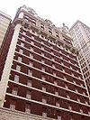
July 14, 1983 1315 Commerce St.
32°46′47″N 96°47′57″W / 32.779722°N 96.799167°WDallas 51 Houston Street Viaduct 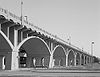
August 9, 1984 Houston St. roughly between Arlington St. and Lancaster Ave.
32°46′12″N 96°48′31″W / 32.77°N 96.808611°WDallas 52 Hyer Hall September 27, 1980 6424 Hill Lane
32°50′41″N 96°47′02″W / 32.844722°N 96.783889°WDallas 53 Interstate Forwarding Company Warehouse February 14, 1992 3200 Main St.
32°47′05″N 96°46′37″W / 32.784722°N 96.776944°WDallas 54 Kessler Park Historic District June 17, 1994 Roughly bounded by Kidd Springs, Stewart, Oak Cliff, Plymouth, I-30, Turner, Colorado and Sylvan
32°45′25″N 96°50′39″W / 32.756944°N 96.844167°WDallas Boundary increase (listed September 7, 1995): Bounded by Turner, Colorado, Sylvan and Salmon 55 King's Highway Historic District June 17, 1994 900-1500 Blocks of King's Highway between W. Davis St. and Montclair Ave.
32°45′07″N 96°50′32″W / 32.751944°N 96.842222°WDallas 56 Lake Cliff Historic District June 17, 1994 Roughly bounded by E. 6th St., Beckley Ave., Zangs Blvd. and Marsalis Ave.
32°45′23″N 96°49′06″W / 32.756389°N 96.818333°WDallas 57 Lancaster Avenue Commercial Historic District June 17, 1994 Roughly bounded by E. Jefferson Blvd., S. Marsalis, E. 10th St., E. 9th St. and N. Lancaster Ave.
32°44′54″N 96°48′53″W / 32.748333°N 96.814722°WDallas 58 Stephen Decatur Lawrence Farmstead September 9, 1999 701 E. Kearney St.
32°46′13″N 96°35′20″W / 32.770278°N 96.588889°WMesquite 59 Mark and Maybelle Lemmon House June 15, 2006 3211 Mockingbird Ln.
32°50′17″N 96°47′04″W / 32.838056°N 96.784444°WHighland Park 60 Levi-Moses House March 23, 1995 2433 Martin Luther King, Jr., Blvd.
32°45′56″N 96°46′20″W / 32.765556°N 96.772222°WDallas 61 Levi-Topletz House March 23, 1995 2603 Martin Luther King, Jr., Blvd.
32°46′02″N 96°46′13″W / 32.767222°N 96.770278°WDallas 62 Lincoln Paint and Color Company Building July 11, 2002 3210 Main
32°47′06″N 96°46′36″W / 32.785°N 96.776667°WDallas 63 Magnolia Building 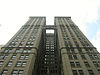
January 30, 1978 108 S. Akard St.
32°46′48″N 96°47′56″W / 32.78°N 96.798889°WDallas 64 Magnolia Petroleum Company City Sales and Warehouse December 23, 1994 1607 Lyte St.
32°47′33″N 96°48′37″W / 32.7925°N 96.810278°WDallas 65 Majestic Theatre 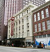
November 14, 1977 1925 Elm St.
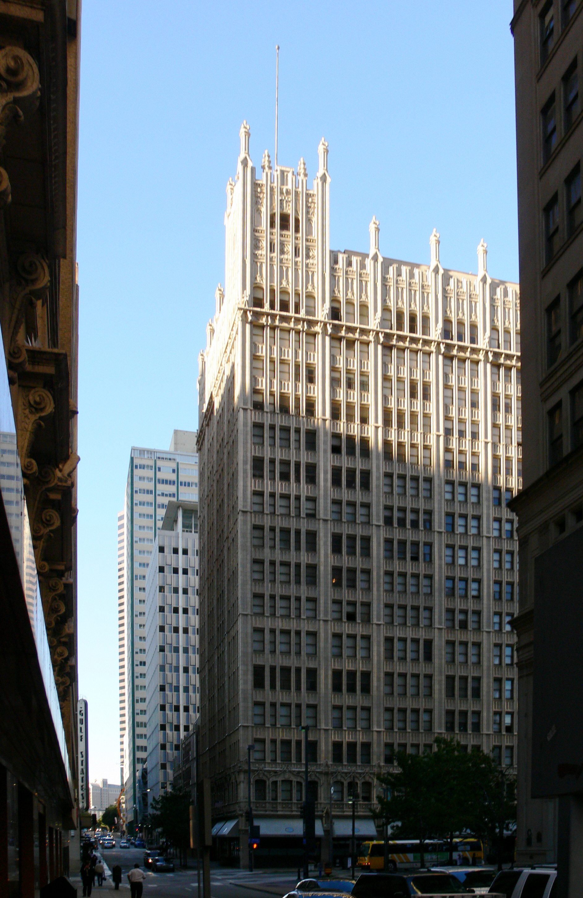
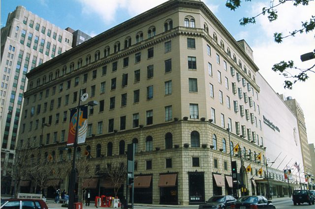
32°47′01″N 96°47′40″W / 32.783611°N 96.794444°WDallas 66 Mary Apartments March 23, 1995 4524 Live Oak
32°47′58″N 96°46′30″W / 32.799444°N 96.775°WDallas 67 McFarlin Memorial Auditorium 
September 27, 1980 6405 Hillcrest Rd.
32°50′38″N 96°47′10″W / 32.843889°N 96.786111°WDallas 68 Roger D. McIntosh House April 7, 1983 1518 Abrams Rd.
32°48′25″N 96°45′13″W / 32.806944°N 96.753611°WDallas 69 Medical Dental Building December 13, 2000 300 Blk. of West Jefferson Blvd.
32°44′36″N 96°49′37″W / 32.743333°N 96.826944°WDallas 70 Miller and Stemmons Historic District June 17, 1994 Roughly bounded by W. Davis St., Woodlawn Ave., Neches and Elsbeth
32°45′09″N 96°49′39″W / 32.7525°N 96.8275°WDallas 71 John Hickman Miller House May 23, 1980 3506 Cedar Springs
32°48′24″N 96°48′20″W / 32.806667°N 96.805556°WDallas 72 John E. Mitchell Company Plant March 4, 1991 3800 Commerce St.
32°47′05″N 96°46′16″W / 32.784722°N 96.771111°WDallas 73 Monroe Shops March 7, 2007 2111 S. Corinth St.
32°43′27″N 96°48′15″W / 32.724167°N 96.804167°WDallas 74 Mrs. Baird's Bread Company Building March 23, 1995 1401 N. Carroll
32°48′01″N 96°46′36″W / 32.800278°N 96.776667°WDallas 75 Munger Place Historic District September 13, 1978 Roughly bounded by Henderson, Junius, Prairie, and Reiger Sts.
32°47′58″N 96°45′51″W / 32.799444°N 96.764167°WDallas 76 North Bishop Avenue Commercial Historic District June 17, 1994 Roughly bounded by 9th St., Davis St., Adams and Madison
32°44′50″N 96°49′42″W / 32.747222°N 96.828333°WDallas 77 Number 4 Hook and Ladder Company May 4, 1981 Cedar Springs Rd. and Reagan St.
32°48′35″N 96°48′32″W / 32.809722°N 96.808889°WDallas 78 Oak Lawn Methodist Episcopal Church, South March 16, 1988 3014 Oak Lawn Ave.
32°48′33″N 96°48′29″W / 32.809167°N 96.808056°WDallas 79 Parkland Hospital October 25, 2011 3819 Maple Avenue
32°48′15″N 96°48′56″W / 32.804236°N 96.815417°WDallas Original Parkland Hospital building 80 Stanley Patterson Hall September 27, 1980 3128 Dyer St.
32°50′36″N 96°46′56″W / 32.843333°N 96.782222°WDallas 81 Peak's Suburban Addition Historic District March 23, 1995 Roughly bounded by Sycamore, Peak, Worth and Fitzhugh
32°47′44″N 96°46′24″W / 32.795556°N 96.773333°WDallas 82 Perkins Hall of Administration September 27, 1980 6425 Hillcrest Rd.
32°50′41″N 96°47′09″W / 32.844722°N 96.785833°WDallas 83 Purvin-Hexter Building January 18, 2006 2038 Commerce St.
32°46′58″N 96°47′35″W / 32.782778°N 96.793056°WDallas 84 Queen City Heights Historic District March 23, 1995 Roughly bounded by Eugene, Cooper, Latimer, Kynard and Dildock
32°45′36″N 96°45′47″W / 32.76°N 96.763056°WDallas 85 Randlett House August 11, 1978 401 S. Centre St.
32°35′26″N 96°45′20″W / 32.590556°N 96.755556°WLancaster 86 Capt. R. A. Rawlins House November 15, 1978 2219 Dowling St.
32°34′49″N 96°45′22″W / 32.580278°N 96.756111°WLancaster 87 Republic National Bank March 31, 2005 300 N. Ervay/325 N. St. Paul St.
32°47′06″N 96°47′51″W / 32.785°N 96.7975°WDallas 88 Dr. Rufus A. Roberts House March 27, 1985 210 S. Broad St.
32°35′17″N 96°57′26″W / 32.588056°N 96.957222°WCedar Hill 89 Romine Avenue Historic District March 23, 1995 2300-2400 blocks of Romine Ave., N side
32°45′32″N 96°45′54″W / 32.758889°N 96.765°WDallas 90 Rosemont Crest Historic District June 17, 1994 Roughly bounded by 10th St., Oak Cliff Blvd., W. Davis St., N. Brighton Ave., W. 8th St. and Rosemont Ave.
32°44′48″N 96°51′02″W / 32.746667°N 96.850556°WDallas 91 Rush-Crabb House March 23, 1995 2718 Pennsylvania
32°45′57″N 96°46′01″W / 32.765833°N 96.766944°WDallas 92 Sanger Brothers Complex April 8, 1975 Block 32, bounded by Elm, Lamar, Main and Austin Sts.
32°46′47″N 96°48′15″W / 32.779722°N 96.804167°WDallas 93 Santa Fe Terminal Buildings No. 1 and No. 2 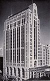
May 23, 1997 1114 Commerce St. and 1118 Jackson St.
32°47′48″N 96°48′03″W / 32.796667°N 96.800833°WDallas 94 Santa Fe Terminal Building No. 4 
June 8, 2011 1033 Young St.
32°46′37″N 96°48′04″W / 32.776944°N 96.801111°WDallas 95 Seagoville School August 10, 2005 306 N. Kaufman St.
32°38′26″N 96°32′25″W / 32.640556°N 96.540278°WSeagoville 96 Thomas Shiels House March 23, 1995 4602 Reiger Ave.
32°47′37″N 96°46′02″W / 32.793611°N 96.767222°WDallas 97 Ascher Silberstein School March 23, 1995 2425 Pine St.
32°45′21″N 96°45′40″W / 32.755833°N 96.761111°WDallas 98 Snider Hall September 27, 1980 3305 Dyer St.
32°50′33″N 96°47′09″W / 32.8425°N 96.785833°WDallas 99 South Boulevard-Park Row Historic District February 5, 1979 South Blvd. and Park Row from Central
32°46′05″N 96°46′20″W / 32.768056°N 96.772222°WDallas 100 Jacob and Eliza Spake House November 21, 1985 2600 State St.
32°47′43″N 96°47′58″W / 32.795278°N 96.799444°WDallas 101 Stanard-Tilton Flour Mill October 6, 1997 2400 S. Ervay St.
32°46′00″N 96°46′55″W / 32.766667°N 96.781944°WDallas 102 Stoneleigh Court Hotel September 18, 2007 2927 Maple Ave.
32°47′51″N 96°48′25″W / 32.7975°N 96.806944°WDallas 103 W. A. Strain House November 29, 1978 400 E. Pecan St.
32°35′16″N 96°44′58″W / 32.587778°N 96.749444°WLancaster Boundary increase (listed September 17, 2001): Strain Farm-W.A. Strain House, 400 Lancaster-Hutchins Rd. 104 Straus House July 12, 1985 400 Cedar
32°35′18″N 96°57′15″W / 32.588333°N 96.954167°WCedar Hill 105 Swiss Avenue Historic District March 28, 1974 Swiss Ave. between Fitzhugh and LaVista
32°48′25″N 96°45′49″W / 32.806944°N 96.763611°WDallas 106 Tenth Street Historic District June 17, 1994 Roughly bounded by E. Clarendon Dr., S. Fleming Ave., I-35E, E. 8th St. and the E end of Church, E. 9th and Plum Sts.
32°44′52″N 96°48′23″W / 32.747778°N 96.806389°WDallas 107 Texas Centennial Exposition Buildings (1936-1937) 
September 24, 1986 Bounded by Texas and Pacific RR, Pennsylvania, Second, and Parry Aves.
32°46′46″N 96°45′35″W / 32.779444°N 96.759722°WDallas 108 Texas Farm and Ranch Building December 9, 1999 3300 Main St.
32°47′07″N 96°46′31″W / 32.785278°N 96.775278°WDallas 109 Texas Theatre 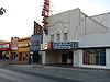
April 1, 2003 231 W. Jefferson Blvd.
32°44′36″N 96°49′32″W / 32.743333°N 96.825556°WDallas 110 Titche-Goettinger Building 
May 24, 1996 1901 Main St.
32°47′26″N 96°47′42″W / 32.790556°N 96.795°WDallas 111 Trinity English Lutheran Church March 23, 1995 3100 Martin Luther King, Jr., Blvd.
32°46′19″N 96°45′52″W / 32.771944°N 96.764444°WDallas 112 Turtle Creek Pump Station February 9, 2001 3630 Harry Hines Blvd.
32°46′06″N 96°48′09″W / 32.768333°N 96.8025°WDallas 113 Viola Courts Apartments January 19, 1984 4845 Swiss Ave.
32°48′04″N 96°46′15″W / 32.801111°N 96.770833°WDallas 114 Virginia Hall September 27, 1980 3325 Dyer St.
32°50′34″N 96°47′11″W / 32.842778°N 96.786389°WDallas 115 Waples-Platter Buildings March 24, 1978 2200-2211 N. Lamar St.
32°47′04″N 96°48′30″W / 32.784444°N 96.808333°WDallas 116 Westend Historic District 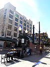
November 14, 1978 Bounded by Lamar, Griffin, Wood, Market, and Commerce Sts.
32°46′44″N 96°48′21″W / 32.778889°N 96.805833°WDallas 117 Wheatley Place Historic District March 23, 1995 Bounded by Warren, Atlanta, McDermott, Meadow, Oakland and Dathe
32°45′54″N 96°45′43″W / 32.765°N 96.761944°WDallas 118 Wilson Block December 15, 1978 2902, 2906, 2910 and 2922 Swiss Ave.
32°47′18″N 96°47′05″W / 32.788333°N 96.784722°WDallas 119 Wilson Building 
July 24, 1979 1621-1623 Main St.
32°46′53″N 96°47′49″W / 32.781389°N 96.796944°WDallas 120 Winnetka Heights Historic District November 3, 1983 Roughly bounded by Davis and 12th Sts., and Rosemont and Willomet Aves.
32°44′39″N 96°50′41″W / 32.744167°N 96.844722°WDallas See also
- Registered Historic Places in Texas, Counties D-G
References
- ^ The latitude and longitude information provided in this table was derived originally from the National Register Information System, which has been found to be fairly accurate for about 99% of listings. For about 1% of NRIS original coordinates, experience has shown that one or both coordinates are typos or otherwise extremely far off; some corrections may have been made. A more subtle problem causes many locations to be off by up to 150 yards, depending on location in the country: most NRIS coordinates were derived from tracing out latitude and longitudes off of USGS topographical quadrant maps created under North American Datum of 1927, which differs from the current, highly accurate GPS system used by Google maps. Chicago is about right, but NRIS longitudes in Washington are higher by about 4.5 seconds, and are lower by about 2.0 seconds in Maine. Latitudes differ by about 1.0 second in Florida. Some locations in this table may have been corrected to current GPS standards.
- ^ "National Register of Historic Places: Weekly List Actions". National Park Service, United States Department of the Interior. Retrieved on November 10, 2011.
- ^ Numbers represent an ordering by significant words. Various colorings, defined here, differentiate National Historic Landmark sites and National Register of Historic Places Districts from other NRHP buildings, structures, sites or objects.
- ^ "National Register Information System". National Register of Historic Places. National Park Service. . http://nrhp.focus.nps.gov/natreg/docs/All_Data.html.
U.S. National Register of Historic Places Topics Lists by states Alabama • Alaska • Arizona • Arkansas • California • Colorado • Connecticut • Delaware • Florida • Georgia • Hawaii • Idaho • Illinois • Indiana • Iowa • Kansas • Kentucky • Louisiana • Maine • Maryland • Massachusetts • Michigan • Minnesota • Mississippi • Missouri • Montana • Nebraska • Nevada • New Hampshire • New Jersey • New Mexico • New York • North Carolina • North Dakota • Ohio • Oklahoma • Oregon • Pennsylvania • Rhode Island • South Carolina • South Dakota • Tennessee • Texas • Utah • Vermont • Virginia • Washington • West Virginia • Wisconsin • WyomingLists by territories Lists by associated states Other Categories:- Dallas County, Texas
- National Register of Historic Places in Texas
- Buildings and structures in Dallas County, Texas
-


Wikimedia Foundation. 2010.