- National Register of Historic Places listings in Colfax County, New Mexico
-
 Location of Colfax County in New Mexico
This is a list of the National Register of Historic Places listings in Colfax County, New Mexico.
This is intended to be a complete list of the properties and districts on the National Register of Historic Places in Colfax County, New Mexico, United States. Latitude and longitude coordinates are provided for many National Register properties and districts; these locations may be seen together in a Google map.[1]
There are 26 properties and districts listed on the National Register in the county, including 2 National Historic Landmarks.
-
- This National Park Service list is complete through NPS recent listings posted November 10, 2011.[2]
Contents: Counties in New Mexico Bernalillo – Catron – Chaves – Cibola – Colfax – Curry – De Baca – Doña Ana – Eddy – Grant – Guadalupe – Harding – Hidalgo – Lea – Lincoln – Los Alamos – Luna – McKinley – Mora – Otero – Quay – Rio Arriba – Roosevelt – San Juan – San Miguel – Sandoval – Santa Fe – Sierra – Socorro – Taos – Torrance – Union – Valencia Current listings
[3] Landmark name [4] Image Date listed Location City or town Summary 1 Catskill Charcoal Ovens January 30, 1978 35 miles (56 km) west of Raton
36°56′07″N 104°46′36″W / 36.935278°N 104.776667°WRaton 2 Cimarron Historic District 
April 3, 1973 Southern edge of city along State Road 21
36°30′16″N 104°55′17″W / 36.504444°N 104.921389°WCimarron 3 Clifton House Site 
April 7, 1995 Address Restricted Raton 4 Colfax County Courthouse 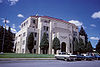
June 18, 1987 3rd and Savage
36°54′15″N 104°26′26″W / 36.904167°N 104.440556°WRaton 5 Colfax County Courthouse in Springer 
December 7, 1987 614 Maxwell Ave.
36°29′53″N 104°35′27″W / 36.498056°N 104.590833°WSpringer 6 Columbian School March 15, 1996 700 N. 2nd St.
36°54′36″N 104°26′13″W / 36.91°N 104.436944°WRaton 7 R.H. Cowan Livery Stable August 3, 1979 220 Maxwell Ave.
36°21′34″N 104°35′41″W / 36.359444°N 104.594722°WSpringer 8 Dawson Cemetery April 9, 1992 Approximately 4 miles northwest of the junction of U.S. Route 64 and the Dawson Rd.
36°39′19″N 104°46′02″W / 36.655278°N 104.767222°WDawson 9 Dorsey Mansion September 4, 1970 About 12 miles northeast of Abbott off U.S. Route 56
36°29′12″N 104°11′28″W / 36.486667°N 104.191111°WAbbott 10 Eagle Nest Dam 
April 18, 1979 3 miles southeast of Eagle Nest off U.S. Route 64
36°31′54″N 105°13′44″W / 36.531667°N 105.228889°WEagle Nest 11 El Raton Theater January 17, 2007 115 N. 2nd St.
36°54′15″N 104°26′21″W / 36.904167°N 104.439167°WRaton 12 El Vado de las Piedras and the Santa Fe Trail-Colfax County Trail Segments April 21, 1994 1.5 miles south of U.S. Route 56 at the Canadian River
36°18′10″N 104°29′21″W / 36.302778°N 104.489167°WSpringer 13 Folsom Site 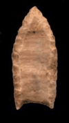
October 15, 1966 Address Restricted Folsom 14 Kearny School March 15, 1996 800 S. 3rd St.
36°53′42″N 104°26′32″W / 36.895°N 104.442222°WRaton 15 Longfellow School March 15, 1996 700 E. 4th St.
36°53′53″N 104°26′04″W / 36.898056°N 104.434444°WRaton 16 Maxwell-Abreu and North (Martinez) Houses June 23, 1993 Northwestern corner of the junction of State Road 121 and Rayado Creek
36°22′04″N 104°55′49″W / 36.367778°N 104.930278°WCimarron 17 Mills House October 6, 1970 509 1st St.
36°21′26″N 104°35′30″W / 36.357222°N 104.591667°WSpringer 18 Original Townsite Historic District March 27, 2008 Roughly bounded by Clark and Cimmaron Aves. and S. 2nd and S. 7th Sts.
36°53′58″N 104°26′37″W / 36.89939°N 104.44359°WRaton 19 Point of Rocks Historic District April 21, 1994 Jones Well Rd., 1.5 miles east of Point of Rocks Rd.
36°25′19″N 104°09′32″W / 36.421944°N 104.158889°WSpringer 20 Raton Armory March 15, 1996 901 S. 3rd St.
36°53′33″N 104°26′33″W / 36.8925°N 104.4425°WRaton 21 Raton Downtown Historic District 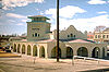
October 21, 1977 Roughly bounded by Rio Grande, Clark, 1st and 3rd Sts.
36°53′58″N 104°26′21″W / 36.899444°N 104.439167°WRaton 22 Raton Junior-Senior High School March 15, 1996 500 S. 3rd St.
36°53′51″N 104°26′31″W / 36.8975°N 104.441944°WRaton 23 Raton Pass 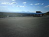
October 15, 1966 U.S. Routes 85/87 on the Colorado/New Mexico border
36°59′19″N 104°29′11″W / 36.988611°N 104.486389°WRaton 24 The Ring Place July 19, 1988 Questa Ranger District in the Carson National Forest, Forest Rds. 1950 and 1918A
36°46′21″N 105°07′16″W / 36.7725°N 105.121111°WCimarron 25 St. John's Methodist Episcopal Church January 18, 1978 17 miles (27 km) east of Raton on State Road 72
36°54′52″N 104°12′18″W / 36.914444°N 104.205°WRaton 26 Villa Philmonte Historic District 
August 18, 1995 Philmont Scout Ranch
36°27′33″N 104°56′56″W / 36.459167°N 104.948889°WCimarron See also
- List of National Historic Landmarks in New Mexico
- National Register of Historic Places listings in New Mexico
References
- ^ The latitude and longitude information provided in this table was derived originally from the National Register Information System, which has been found to be fairly accurate for about 99% of listings. For about 1% of NRIS original coordinates, experience has shown that one or both coordinates are typos or otherwise extremely far off; some corrections may have been made. A more subtle problem causes many locations to be off by up to 150 yards, depending on location in the country: most NRIS coordinates were derived from tracing out latitude and longitudes off of USGS topographical quadrant maps created under the North American Datum of 1927, which differs from the current, highly accurate WGS84 GPS system used by Google maps. Chicago is about right, but NRIS longitudes in Washington are higher by about 4.5 seconds, and are lower by about 2.0 seconds in Maine. Latitudes differ by about 1.0 second in Florida. Some locations in this table may have been corrected to current GPS standards.
- ^ "National Register of Historic Places: Weekly List Actions". National Park Service, United States Department of the Interior. Retrieved on November 10, 2011.
- ^ Numbers represent an ordering by significant words. Various colorings, defined here, differentiate National Historic Landmark sites and National Register of Historic Places Districts from other NRHP buildings, structures, sites or objects.
- ^ "National Register Information System". National Register of Historic Places. National Park Service. . http://nrhp.focus.nps.gov/natreg/docs/All_Data.html.
U.S. National Register of Historic Places Topics Lists by states Alabama • Alaska • Arizona • Arkansas • California • Colorado • Connecticut • Delaware • Florida • Georgia • Hawaii • Idaho • Illinois • Indiana • Iowa • Kansas • Kentucky • Louisiana • Maine • Maryland • Massachusetts • Michigan • Minnesota • Mississippi • Missouri • Montana • Nebraska • Nevada • New Hampshire • New Jersey • New Mexico • New York • North Carolina • North Dakota • Ohio • Oklahoma • Oregon • Pennsylvania • Rhode Island • South Carolina • South Dakota • Tennessee • Texas • Utah • Vermont • Virginia • Washington • West Virginia • Wisconsin • WyomingLists by territories Lists by associated states Other Municipalities and communities of Colfax County, New Mexico City 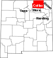
Town Villages Angel Fire | Cimarron | Eagle Nest | Maxwell
Unincorporated
communitiesMiami | Rayado | Sunny Side | Ute Park
Ghost towns Categories:- National Register of Historic Places in New Mexico by county
- Colfax County, New Mexico
- History of Colfax County, New Mexico
-


Wikimedia Foundation. 2010.