- National Register of Historic Places listings in Cocke County, Tennessee
-
 Location of Cocke County in Tennessee
This is a list of the National Register of Historic Places listings in Cocke County, Tennessee.
This is intended to be a complete list of the properties and districts on the National Register of Historic Places in Cocke County, Tennessee, United States. Latitude and longitude coordinates are provided for many National Register properties and districts; these locations may be seen together in a Google map.[1]
There are 12 properties and districts listed on the National Register in the county. Conway Bridge is listed in the NRHP NRIS database in both Cocke and Greene County.[2]
Contents: Counties in Tennessee Anderson – Bedford – Benton – Bledsoe – Blount – Bradley – Campbell – Cannon – Carroll – Carter – Cheatham – Chester – Claiborne – Clay – Cocke – Coffee – Crockett – Cumberland – Davidson – Decatur – DeKalb – Dickson – Dyer – Fayette – Fentress – Franklin – Gibson – Giles – Grainger – Greene – Grundy – Hamblen – Hamilton – Hancock – Hardeman – Hardin – Hawkins – Haywood – Henderson – Henry – Hickman – Houston – Humphreys – Jackson – Jefferson – Johnson – Knox – Lake – Lauderdale – Lawrence – Lewis – Lincoln – Loudon – Macon – Madison – Marion – Marshall – Maury – McMinn – McNairy – Meigs – Monroe – Montgomery – Moore – Morgan – Obion – Overton – Perry – Pickett – Polk – Putnam – Rhea – Roane – Robertson – Rutherford – Scott – Sequatchie – Sevier – Shelby – Smith – Stewart – Sullivan – Sumner – Tipton – Trousdale – Unicoi – Union – Van Buren – Warren – Washington – Wayne – Weakley – White – Williamson – Wilson -
- This National Park Service list is complete through NPS recent listings posted November 10, 2011.[3]
Current listings
[4] Landmark name [5] Image Date listed Location City or town Summary 1 Beechwood Hall May 29, 1975 North of Newport on Rankin Rd.
35°59′27″N 83°10′59″W / 35.990833°N 83.183056°WNewport 2 Cocke County Courthouse 
May 4, 1995 111 Court Ave.
35°58′00″N 83°11′05″W / 35.966667°N 83.184722°WNewport 3 Cocke County Memorial Building 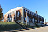
September 11, 1997 103 N. Cosby Highway
35°58′03″N 83°11′36″W / 35.9675°N 83.193333°WNewport 4 Conway Bridge November 20, 2009 Briar Thicket Rd./Knob Creek Rd. over the Nolichucky River
36°07′21″N 83°07′31″W / 36.1225°N 83.125278°WBriar Thicket Extends into Greene County[2] 5 Walter C. Cureton House November 29, 2001 202 Lincoln Ave.
35°57′44″N 83°10′44″W / 35.962222°N 83.178889°WNewport 6 Elm Hill 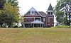
May 29, 1975 206 W. Riverview St.
35°57′56″N 83°11′27″W / 35.965556°N 83.190833°WNewport 7 Neas Farm March 10, 2004 3301 Sable Rd.
36°01′56″N 83°00′46″W / 36.032222°N 83.012778°WParrottsville 8 O'Dell House 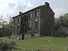
April 1, 1975 Northeast of Newport on the Greeneville Highway
35°58′55″N 83°09′46″W / 35.981944°N 83.162778°WNewport 9 Rhea-Mims Hotel 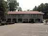
July 1, 1998 335 East Broadway
35°57′57″N 83°11′01″W / 35.965833°N 83.183611°WNewport 10 Swaggerty Blockhouse 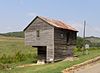
June 18, 1973 East of Parrottsville on U.S. Route 411
36°00′47″N 83°04′17″W / 36.013056°N 83.071389°WParrottsville 11 Vinson House May 29, 1975 4.5 miles south of Newport off Hartford Rd.
35°53′21″N 83°11′06″W / 35.889167°N 83.185°WNewport 12 Yett-Ellison House April 16, 1975 Main St. (Greeneville Highway)
36°00′29″N 83°05′19″W / 36.008056°N 83.088611°WParrottsville See also
- List of National Historic Landmarks in Tennessee
- National Register of Historic Places listings in Tennessee
References
- ^ The latitude and longitude information provided in this table was derived originally from the National Register Information System, which has been found to be fairly accurate for about 99% of listings. For about 1% of NRIS original coordinates, experience has shown that one or both coordinates are typos or otherwise extremely far off; some corrections may have been made. A more subtle problem causes many locations to be off by up to 150 yards, depending on location in the country: most NRIS coordinates were derived from tracing out latitude and longitudes off of USGS topographical quadrant maps created under the North American Datum of 1927, which differs from the current, highly accurate WGS84 GPS system used by Google maps. Chicago is about right, but NRIS longitudes in Washington are higher by about 4.5 seconds, and are lower by about 2.0 seconds in Maine. Latitudes differ by about 1.0 second in Florida. Some locations in this table may have been corrected to current GPS standards.
- ^ a b "National Register Information System". National Register of Historic Places. National Park Service. . http://nrhp.focus.nps.gov/natreg/docs/All_Data.html.
- ^ "National Register of Historic Places: Weekly List Actions". National Park Service, United States Department of the Interior. Retrieved on November 10, 2011.
- ^ Numbers represent an ordering by significant words. Various colorings, defined here, differentiate National Historic Landmark sites and National Register of Historic Places Districts from other NRHP buildings, structures, sites or objects.
- ^ "National Register Information System". National Register of Historic Places. National Park Service. . http://nrhp.focus.nps.gov/natreg/docs/All_Data.html.
U.S. National Register of Historic Places Topics Lists by states Alabama • Alaska • Arizona • Arkansas • California • Colorado • Connecticut • Delaware • Florida • Georgia • Hawaii • Idaho • Illinois • Indiana • Iowa • Kansas • Kentucky • Louisiana • Maine • Maryland • Massachusetts • Michigan • Minnesota • Mississippi • Missouri • Montana • Nebraska • Nevada • New Hampshire • New Jersey • New Mexico • New York • North Carolina • North Dakota • Ohio • Oklahoma • Oregon • Pennsylvania • Rhode Island • South Carolina • South Dakota • Tennessee • Texas • Utah • Vermont • Virginia • Washington • West Virginia • Wisconsin • WyomingLists by territories Lists by associated states Other Municipalities and communities of Cocke County, Tennessee City 
Town Unincorporated
communitiesCategories:- National Register of Historic Places in Tennessee by county
- Cocke County, Tennessee
- Buildings and structures in Cocke County, Tennessee
-


Wikimedia Foundation. 2010.