- National Register of Historic Places listings in Coahoma County, Mississippi
-
 Location of Coahoma County in Mississippi
This is a list of the National Register of Historic Places listings in Coahoma County, Mississippi.
This is intended to be a complete list of the properties and districts on the National Register of Historic Places in Coahoma County, Mississippi, United States. Latitude and longitude coordinates are provided for many National Register properties and districts; these locations may be seen together in a Google map.[1]
There are 21 properties and districts listed on the National Register in the county.
-
- This National Park Service list is complete through NPS recent listings posted November 10, 2011.[2]
Current listings
[3] Landmark name [4] Image Date listed Location City or town Summary 1 Barner Site (22CO542) March 8, 1984 Address Restricted Clarksdale 2 Bobo Senior High School Building March 19, 2008 131 School St.
34°11′57″N 90°34′43″W / 34.199167°N 90.578611°WClarksdale 3 Carson Mounds April 19, 1979 Address Restricted Clarksdale 4 John Clark House July 5, 2003 211 Clark St.
34°12′23″N 90°34′28″W / 34.206389°N 90.574444°WClarksdale 5 Clarksdale Historic District September 4, 2009 Roughly bounded by the Sunflower River, 10th St., DeSoto Ave., and Clark St.
34°11′55″N 90°34′10″W / 34.198564°N 90.569381°WClarksdale 6 Rufus Davis Site June 15, 1978 Address Restricted Clarksdale 7 Dickerson Site (22CO502) September 11, 1986 Address Restricted Friars Point 8 Friars Point Historic District 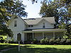
January 28, 1999 Along 2nd St.
34°22′20″N 90°38′14″W / 34.372222°N 90.637222°WFriars Point 9 Humber Site May 12, 1975 Address Restricted Farrel 10 New Alcazar Hotel 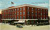
June 24, 1994 127 3rd St.
34°12′05″N 90°34′25″W / 34.201389°N 90.573611°WClarksdale 11 Oliver Site December 30, 1974 Address Restricted Clarksdale 12 Parchman Place Site May 17, 1973 Address Restricted Coahoma 13 Prairie Plantation House November 10, 1994 1545 Old River Rd.
34°18′22″N 90°39′12″W / 34.306111°N 90.653333°WClarksdale 14 Salomon (Salmon) Site March 8, 1984 Address Restricted Coahoma 15 Spendthrift Site (22CO520) September 11, 1986 Address Restricted Mattson 16 Sunflower Landing October 2, 1991 Address Restricted Rena Lara 17 Wilsford December 30, 1974 Address Restricted Lula 18 Woolworth Building None 207 Yazoo Ave.
34°12′10″N 90°34′25″W / 34.202794°N 90.573708°WClarksdale 19 WROX Building August 9, 2002 257 Delta Ave.
34°12′05″N 90°34′29″W / 34.201389°N 90.574722°WClarksdale 20 Yazoo and Mississippi Valley Passenger Depot 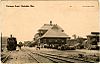
October 31, 1995 1 Blues Alley
34°12′03″N 90°34′15″W / 34.200833°N 90.570833°WClarksdale Later the Illinois Central 21 Yazoo Pass Levee June 19, 1973 Near Moon Lake on Mississippi Highway 1
34°26′57″N 90°33′02″W / 34.449167°N 90.550556°WMoon Lake See also
- List of National Historic Landmarks in Mississippi
- National Register of Historic Places listings in Mississippi
References
- ^ The latitude and longitude information provided in this table was derived originally from the National Register Information System, which has been found to be fairly accurate for about 99% of listings. For about 1% of NRIS original coordinates, experience has shown that one or both coordinates are typos or otherwise extremely far off; some corrections may have been made. A more subtle problem causes many locations to be off by up to 150 yards, depending on location in the country: most NRIS coordinates were derived from tracing out latitude and longitudes off of USGS topographical quadrant maps created under the North American Datum of 1927, which differs from the current, highly accurate WGS84 GPS system used by Google maps. Chicago is about right, but NRIS longitudes in Washington are higher by about 4.5 seconds, and are lower by about 2.0 seconds in Maine. Latitudes differ by about 1.0 second in Florida. Some locations in this table may have been corrected to current GPS standards.
- ^ "National Register of Historic Places: Weekly List Actions". National Park Service, United States Department of the Interior. Retrieved on November 10, 2011.
- ^ Numbers represent an ordering by significant words. Various colorings, defined here, differentiate National Historic Landmark sites and National Register of Historic Places Districts from other NRHP buildings, structures, sites or objects.
- ^ "National Register Information System". National Register of Historic Places. National Park Service. . http://nrhp.focus.nps.gov/natreg/docs/All_Data.html.
U.S. National Register of Historic Places Topics Lists by states Alabama • Alaska • Arizona • Arkansas • California • Colorado • Connecticut • Delaware • Florida • Georgia • Hawaii • Idaho • Illinois • Indiana • Iowa • Kansas • Kentucky • Louisiana • Maine • Maryland • Massachusetts • Michigan • Minnesota • Mississippi • Missouri • Montana • Nebraska • Nevada • New Hampshire • New Jersey • New Mexico • New York • North Carolina • North Dakota • Ohio • Oklahoma • Oregon • Pennsylvania • Rhode Island • South Carolina • South Dakota • Tennessee • Texas • Utah • Vermont • Virginia • Washington • West Virginia • Wisconsin • WyomingLists by territories Lists by associated states Other Municipalities and communities of Coahoma County, Mississippi City 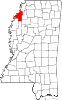
Towns Coahoma | Friars Point | Jonestown | Lula | Lyon
Unincorporated
communitiesBobo | Cagles Crossing | Claremont | Clover Hill | Dublin | Eagles Nest | Farrell | Hillhouse | Lurand | Mattson | Moon Lake | Rena Lara | Rich | Roundaway | Rudyard | Sherard | Stovall
Ghost town Ingram‡
Footnotes ‡This populated place also has portions in an adjacent county or counties
Categories:- Coahoma County, Mississippi
- National Register of Historic Places in Mississippi by county
- Buildings and structures in Coahoma County, Mississippi
-


Wikimedia Foundation. 2010.