- National Register of Historic Places listings in Charles City County, Virginia
-
This list includes properties and districts listed on the National Register of Historic Places in Charles City County, Virginia. Click the "Map of all coordinates" link to the right to view a Google map of all properties and districts with latitude and longitude coordinates in the table below.[1]
-
- This National Park Service list is complete through NPS recent listings posted November 10, 2011.[2]
Contents
Current listings
[3] Landmark name [4] Image Date listed Location City or town Summary 1 Belle Air July 18, 1974 N of VA 5
37°20′49″N 77°03′40″W / 37.346944°N 77.061111°WCharles City 2 Berkeley 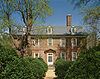
November 11, 1971 8 mi. W of Charles City
37°19′18″N 77°10′54″W / 37.321667°N 77.181667°WCharles City 3 Lott Cary Birth Site July 30, 1980 NW of Charles City on VA 602
37°23′03″N 77°04′53″W / 37.384167°N 77.081389°WCharles City 4 Charles City County Courthouse 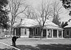
November 12, 1969 VA 5
37°20′29″N 77°04′21″W / 37.341389°N 77.0725°WCharles City 5 Dogham, Doggams September 24, 1999 1601 Dogham Ln.
37°21′43″N 77°14′01″W / 37.361944°N 77.233611°WCharles City 6 Edgewood February 10, 1983 W of Charles City on VA 5
37°19′49″N 77°11′12″W / 37.330278°N 77.186667°WCharles City 7 Eppes Island November 12, 1969 Address Restricted Hopewell 8 Evelynton August 17, 1989 VA 5 E of VA 609
37°19′48″N 77°09′16″W / 37.33°N 77.154444°WCharles City 9 Fort Pocahontas July 27, 1999 Address Restricted Charles City 10 Glebe of Westover Parish June 5, 1975 SW of Ruthville off VA 615
37°21′43″N 77°03′13″W / 37.361944°N 77.053611°WRuthville 11 Greenway 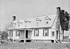
November 12, 1969 On VA 5
37°20′19″N 77°05′20″W / 37.338611°N 77.088889°WCharles City 12 Hardens February 10, 1983 W of Lamptie Hill on VA 5
37°22′16″N 77°14′12″W / 37.371111°N 77.236667°WLamptie Hill 13 Aaron Hilton Site February 21, 1997 Address Restricted Charles City 14 Kittiewan December 28, 1979 2.5 mi. SE of New Hope
37°18′05″N 77°02′51″W / 37.301389°N 77.0475°WNew Hope 15 Margots August 17, 1973 NE of Tettington off VA 621
37°18′35″N 76°53′19″W / 37.309722°N 76.888611°WTettington 16 Mount Stirling February 4, 1993 VA 155 E side, 3200 ft. NNE of jct. with VA 614
37°25′32″N 77°02′14″W / 37.425556°N 77.037222°WProvidence Forge 17 Nance-Major House and Store August 16, 2006 10811 Courthouse Rd.
37°20′39″N 77°04′25″W / 37.344167°N 77.073611°WCharles City 18 North Bend August 21, 1989 VA 619
37°18′42″N 77°03′21″W / 37.311667°N 77.055833°WWeyanoke 19 Piney Grove November 26, 1985 VA 615
37°22′24″N 76°58′42″W / 37.373333°N 76.978333°WHoldcroft 20 Poplar Springs August 30, 1994 17300 The Glebe Ln.
37°22′40″N 76°58′15″W / 37.377778°N 76.970833°WCharles City 21 Shirley 
October 1, 1969 5 mi. N of Hopewell off VA 608
37°21′21″N 77°14′39″W / 37.355833°N 77.244167°WHopewell 22 John Tyler House 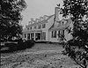
October 15, 1966 4 mi. E of Charles City on VA 5
37°19′29″N 77°01′14″W / 37.324722°N 77.020556°WCharles City 23 Upper Shirley October 29, 1982 W of Charles City on SR 608
37°20′50″N 77°15′24″W / 37.347222°N 77.256667°WCharles City 24 Upper Weyanoke December 9, 1980 S. of Charles City on VA 619
37°17′54″N 77°04′25″W / 37.298333°N 77.073611°WCharles City 25 Westover 
October 15, 1966 7 mi. W of Charles City on VA 5
37°19′12″N 77°09′21″W / 37.32°N 77.155833°WCharles City 26 Westover Church 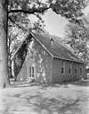
December 5, 1972 5 mi. W of Charles City off VA 5
37°19′56″N 77°09′33″W / 37.332222°N 77.159167°WCharles City 27 Weyanoke March 10, 1980 Address Restricted Charles City 28 Woodburn December 12, 1978 NW of Charles on VA 618
37°21′20″N 77°06′39″W / 37.355556°N 77.110833°WCharles City Delisted resources
[3] Landmark name Image Date listed Location City or town Summary 1 The Rowe March 28, 1980 3 mi. SW of Rustic
37°15′17″N 76°57′43″W / 37.254722°N 76.961944°WRustic Delisted June 4, 2008 See also
- National Register of Historic Places listings in Virginia
- National Register of Historic Places listings in Hopewell, Virginia
- List of National Historic Landmarks in Virginia
References
- ^ The latitude and longitude information provided in this table was derived originally from the National Register Information System, which has been found to be fairly accurate for about 99% of listings. For about 1% of NRIS original coordinates, experience has shown that one or both coordinates are typos or otherwise extremely far off; some corrections may have been made. A more subtle problem causes many locations to be off by up to 150 yards, depending on location in the country: most NRIS coordinates were derived from tracing out latitude and longitudes off of USGS topographical quadrant maps created under the North American Datum of 1927, which differs from the current, highly accurate WGS84 GPS system used by Google maps. Chicago is about right, but NRIS longitudes in Washington are higher by about 4.5 seconds, and are lower by about 2.0 seconds in Maine. Latitudes differ by about 1.0 second in Florida. Some locations in this table may have been corrected to current GPS standards.
- ^ "National Register of Historic Places: Weekly List Actions". National Park Service, United States Department of the Interior. Retrieved on November 10, 2011.
- ^ a b Numbers represent an ordering by significant words. Various colorings, defined here, differentiate National Historic Landmark sites and National Register of Historic Places Districts from other NRHP buildings, structures, sites or objects.
- ^ "National Register Information System". National Register of Historic Places. National Park Service. . http://nrhp.focus.nps.gov/natreg/docs/All_Data.html.
U.S. National Register of Historic Places Topics Lists by states Alabama • Alaska • Arizona • Arkansas • California • Colorado • Connecticut • Delaware • Florida • Georgia • Hawaii • Idaho • Illinois • Indiana • Iowa • Kansas • Kentucky • Louisiana • Maine • Maryland • Massachusetts • Michigan • Minnesota • Mississippi • Missouri • Montana • Nebraska • Nevada • New Hampshire • New Jersey • New Mexico • New York • North Carolina • North Dakota • Ohio • Oklahoma • Oregon • Pennsylvania • Rhode Island • South Carolina • South Dakota • Tennessee • Texas • Utah • Vermont • Virginia • Washington • West Virginia • Wisconsin • WyomingLists by territories Lists by associated states Other Municipalities and communities of Charles City County, Virginia CDP 
Unincorporated
communitiesBarnetts | Berkeley | Binns Hall | Blanks Store | Ednas Mill | Granville | Greenway | Harrisons Landing | Holdcroft | Kennon | Kimages | Milton | Montpelier | Mount Airy | Nance | New Hope | Roaches Corner | Rolands Mill | The Row | Roxbury | Rustic | Ruthville | Sandybottom | Sherwood Forest | Shirley | Tettington | Wayside | Westover | Weyanoke
Categories:- Charles City County, Virginia
- National Register of Historic Places in Virginia
- Virginia-related lists
-


Wikimedia Foundation. 2010.