- National Register of Historic Places listings in Cass County, Nebraska
-
 Location of Cass County in Nebraska
This is a list of the National Register of Historic Places listings in Cass County, Nebraska. It is intended to be a complete list of the properties and districts on the National Register of Historic Places in Cass County, Nebraska, United States. The locations of National Register properties and districts for which the latitude and longitude coordinates are included below, may be seen in a Google map.[1]
There are 24 properties and districts listed on the National Register in the county, including 1 National Historic Landmark.
-
- This National Park Service list is complete through NPS recent listings posted November 10, 2011.[2]
Listings county-wide
[3] Landmark name [4] Image Date listed Location City or town Summary 1 Ashland Archeological Site February 10, 1975 Address Restricted Ashland 2 Bridge June 29, 1992 County road over an unnamed stream, 4.7 miles southeast of Louisville
40°58′22″N 96°04′55″W / 40.972778°N 96.081944°WLouisville 3 Cass County Courthouse 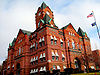
January 10, 1990 Main St. between 3rd and 4th Sts.
41°00′42″N 95°52′59″W / 41.011667°N 95.883056°WPlattsmouth 4 Theodore Davis Site May 19, 1972 Address Restricted Weeping Water 5 Paul Fitzgerald House March 2, 2006 513 E. 2nd St.
41°00′04″N 96°09′22″W / 41.001111°N 96.156111°WLouisville 6 Paul Gering House July 12, 2006 423 N. 6th St.
41°00′54″N 95°53′08″W / 41.015°N 95.885556°WPlattsmouth 7 Gibson House March 20, 1986 107 Clinton
40°52′15″N 96°08′39″W / 40.870833°N 96.144167°WWeeping Water 8 Walker Gilmore Site (22CC28) October 15, 1966 Address Restricted Murray 9 James and Margaret Greer Farmstead March 21, 2011 6135 202nd St.
40°53′18″N 96°26′49″W / 40.888333°N 96.446944°WAlvo vicinity 10 Kehlbeck Farmstead September 26, 1985 Address Restricted Avoca 11 Manley School December 30, 2004 115 Cherry St.
40°55′13″N 96°10′03″W / 40.920278°N 96.1675°WManley 12 McLaughlin-Waugh-Dovey House October 14, 1980 414 B Ave.
41°00′49″N 95°53′04″W / 41.013611°N 95.884444°WPlattsmouth 13 Naomi Institute March 24, 1977 3 miles east of Murray
40°55′45″N 95°51′09″W / 40.929167°N 95.8525°WMurray 14 Nehawka Flint Quarries January 26, 1970 Address Restricted Nehawka 15 Nehawka Public Library December 5, 2002 Junction of Elm and Master Sts.
40°49′44″N 95°59′18″W / 40.828889°N 95.988333°WNehawka 16 Capt. John O'Rourke House March 2, 2006 424 N. 6th St.
41°00′54″N 95°53′10″W / 41.015°N 95.886111°WPlattsmouth 17 Glenn and Addie Perry Farmhouse November 8, 2006 Address Restricted Plattsmouth 18 Plattsmouth Bridge 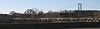
April 15, 1993 U.S. Route 34 over the Missouri River
41°00′02″N 95°51′58″W / 41.000556°N 95.866111°WPlattsmouth Extends into Mills County, Iowa 19 Plattsmouth Main Street Historic District 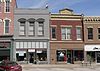
September 26, 1985 Main St. bounded by Avenue A, S. and N. 3rd St., 1st Ave. and S. and N. 7th St.
41°00′41″N 95°53′04″W / 41.011389°N 95.884444°WPlattsmouth 20 Snoke Farmstead March 5, 1998 23416 O St., U.S. Highway 34
40°48′50″N 96°23′39″W / 40.813889°N 96.394167°WEagle 21 The Elms March 24, 1977 Off Nebraska Highway 1
40°50′39″N 96°17′30″W / 40.844167°N 96.291667°WElmwood 22 Union Jail July 12, 2006 1st and Rock St.
40°48′45″N 95°55′18″W / 40.8125°N 95.921667°WUnion 23 Weeping Water Historic District December 8, 1972 Randolph and H Sts.
40°52′16″N 96°08′32″W / 40.871111°N 96.142222°WWeeping Water 24 Young Cemetery Cabin December 30, 2004 Young Ln. E400
40°56′26″N 95°54′16″W / 40.940556°N 95.904444°WPlattsmouth See also
- List of National Historic Landmarks in Nebraska
- National Register of Historic Places listings in Nebraska
References
- ^ The latitude and longitude information provided in this table was derived originally from the National Register Information System, which has been found to be fairly accurate for about 99% of listings. For about 1% of NRIS original coordinates, experience has shown that one or both coordinates are typos or otherwise extremely far off; some corrections may have been made. A more subtle problem causes many locations to be off by up to 150 yards, depending on location in the country: most NRIS coordinates were derived from tracing out latitude and longitudes off of USGS topographical quadrant maps created under North American Datum of 1927, which differs from the current, highly accurate GPS system used by Google maps. Chicago is about right, but NRIS longitudes in Washington are higher by about 4.5 seconds, and are lower by about 2.0 seconds in Maine. Latitudes differ by about 1.0 second in Florida. Some locations in this table may have been corrected to current GPS standards.
- ^ "National Register of Historic Places: Weekly List Actions". National Park Service, United States Department of the Interior. Retrieved on November 10, 2011.
- ^ Numbers represent an ordering by significant words. Various colorings, defined here, differentiate National Historic Landmark sites and National Register of Historic Places Districts from other NRHP buildings, structures, sites or objects.
- ^ "National Register Information System". National Register of Historic Places. National Park Service. . http://nrhp.focus.nps.gov/natreg/docs/All_Data.html.
U.S. National Register of Historic Places Topics Lists by states Alabama • Alaska • Arizona • Arkansas • California • Colorado • Connecticut • Delaware • Florida • Georgia • Hawaii • Idaho • Illinois • Indiana • Iowa • Kansas • Kentucky • Louisiana • Maine • Maryland • Massachusetts • Michigan • Minnesota • Mississippi • Missouri • Montana • Nebraska • Nevada • New Hampshire • New Jersey • New Mexico • New York • North Carolina • North Dakota • Ohio • Oklahoma • Oregon • Pennsylvania • Rhode Island • South Carolina • South Dakota • Tennessee • Texas • Utah • Vermont • Virginia • Washington • West Virginia • Wisconsin • WyomingLists by territories Lists by associated states Other  Category:National Register of Historic Places •
  Portal:National Register of Historic Places
Municipalities and communities of Cass County, Nebraska County seat: Plattsmouth Cities 
Villages Ghost towns Categories:- National Register of Historic Places in Nebraska by county
- Cass County, Nebraska
- Buildings and structures in Cass County, Nebraska
-


Wikimedia Foundation. 2010.