- National Register of Historic Places listings in Canyonlands National Park
-
This is a list of the National Register of Historic Places listings in Canyonlands National Park.
This is intended to be a complete list of the properties and districts on the National Register of Historic Places in Canyonlands National Park, Utah, United States. The locations of National Register properties and districts for which the latitude and longitude coordinates are included below, may be seen in a Google map.[1]
There are 12 properties and districts listed on the National Register in the park.
-
- This National Park Service list is complete through NPS recent listings posted November 10, 2011.[2]
Current listings
[3] Landmark name[4] Image Date listed Location City or Town Summary 1 Cave Springs Cowboy Camp 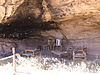
October 7, 1988 Cave Springs vicinity
38°9′34″N 109°45′12″W / 38.15944°N 109.75333°WMoab In the Needles district of Canyonlands National Park 2 D.C.C. & P. Inscription "B" October 7, 1988 Confluence vicinity
38°11′17″N 109°53′12″W / 38.18806°N 109.88667°WMoab 3 Harvest Scene Pictograph 
April 1, 1975 Address Restricted[5] Green River 4 Horseshoe (Barrier) Canyon Pictograph Panels 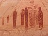
February 23, 1972 Address Restricted Green River 5 Denis Julien Inscription (Grand County, Utah) May 23, 1991 Mouth of Hell Roaring Canyon, Green River Canyon
38°33′49″N 109°59′2″W / 38.56361°N 109.98389°WMoab 6 Denis Julien Inscription (San Juan County, Utah) October 7, 1988 Lower Red Lake vicinity
38°9′16″N 109°55′32″W / 38.15444°N 109.92556°WMoab 7 Kirk's Cabin Complex 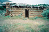
October 7, 1988 Upper Salt Walsh
37°59′16″N 109°44′27″W / 37.98778°N 109.74083°WMoab 8 Kolb Brothers "Cat Camp" Inscription October 7, 1988 Big Drop #2 vicinity
38°4′57″N 110°2′32″W / 38.0825°N 110.04222°WMoab 9 Lost Canyon Cowboy Camp 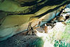
October 7, 1988 Lost Canyon vicinity
38°8′13″N 109°45′32″W / 38.13694°N 109.75889°WMoab 10 Murphy Trail and Bridge October 7, 1988 Murphy Point vicinity
38°20′37″N 109°52′15″W / 38.34361°N 109.87083°WMoab 11 Neck and Cabin Springs Grazing Area December 18, 2009 Grand View Point Rd.
38°25′9.04″N 109°50′4.46″W / 38.4191778°N 109.8345722°WMoab 12 Salt Creek Archeological District March 31, 1975 Address Restricted[5] Monticello See also
- National Register of Historic Places listings in Grand County, Utah
- National Register of Historic Places listings in Wayne County, Utah
- National Register of Historic Places listings in San Juan County, Utah
- National Register of Historic Places listings in Garfield County, Utah
- National Register of Historic Places listings in Utah
References
- National Register of Historic Places Registration Form: Canyonlands National Park Multiple Resource. National Park Service 1988 [1]
- ^ The latitude and longitude information provided in this table was derived originally from the National Register Information System, which has been found to be fairly accurate for about 99% of listings. For about 1% of NRIS original coordinates, experience has shown that one or both coordinates are typos or otherwise extremely far off; some corrections may have been made. A more subtle problem causes many locations to be off by up to 150 yards, depending on location in the country: most NRIS coordinates were derived from tracing out latitude and longitudes off of USGS topographical quadrant maps created under the North American Datum of 1927, which differs from the current, highly accurate WGS84 GPS system used by Google maps. Chicago is about right, but NRIS longitudes in Washington are higher by about 4.5 seconds, and are lower by about 2.0 seconds in Maine. Latitudes differ by about 1.0 second in Florida. Some locations in this table may have been corrected to current GPS standards.
- ^ "National Register of Historic Places: Weekly List Actions". National Park Service, United States Department of the Interior. Retrieved on November 10, 2011.
- ^ Numbers represent an ordering by significant words. Various colorings, defined here, differentiate National Historic Landmark sites and National Register of Historic Places Districts from other NRHP buildings, structures, sites or objects.
- ^ "National Register Information System". National Register of Historic Places. National Park Service. 2008-04-24. http://nrhp.focus.nps.gov/natreg/docs/All_Data.html.
- ^ a b Some listings on the NRHP are highly sensitive sites and may be subject to looting or vandalism. The NRHP lists this site as "Address Restricted."
National Register of Historic Places in Canyonlands National Park Historic districts Kirk's Cabin Complex | Murphy Trail and Bridge | Neck and Cabin Springs Grazing Area | Salt Creek Archeological District
Properties Cave Springs Cowboy Camp | D.C.C. & P. Inscription "B" | Harvest Scene Pictograph | Horseshoe (Barrier) Canyon Pictograph Panels | Denis Julien Inscription (Grand County, Utah) | Denis Julien Inscription (San Juan County, Utah) | Kolb Brothers "Cat Camp" Inscription | Lost Canyon Cowboy Camp
See also: National Register of Historic Places listings in Canyonlands National ParkU.S. National Register of Historic Places Topics Lists by states Alabama • Alaska • Arizona • Arkansas • California • Colorado • Connecticut • Delaware • Florida • Georgia • Hawaii • Idaho • Illinois • Indiana • Iowa • Kansas • Kentucky • Louisiana • Maine • Maryland • Massachusetts • Michigan • Minnesota • Mississippi • Missouri • Montana • Nebraska • Nevada • New Hampshire • New Jersey • New Mexico • New York • North Carolina • North Dakota • Ohio • Oklahoma • Oregon • Pennsylvania • Rhode Island • South Carolina • South Dakota • Tennessee • Texas • Utah • Vermont • Virginia • Washington • West Virginia • Wisconsin • WyomingLists by territories Lists by associated states Other Categories:- Canyonlands National Park
- National Register of Historic Places lists in the National Park Service
-


Wikimedia Foundation. 2010.