- National Register of Historic Places listings in Buchanan County, Iowa
-
 Location of Buchanan County in Iowa
This is a list of the National Register of Historic Places listings in Buchanan County, Iowa.
This is intended to be a complete list of the properties and districts on the National Register of Historic Places in Buchanan County, Iowa, United States. Latitude and longitude coordinates are provided for many National Register properties and districts; these locations may be seen together in a Google map.[1]
There are 19 properties and districts listed on the National Register in the county.
-
- This National Park Service list is complete through NPS recent listings posted November 10, 2011.[2]
Contents
Current listings
[3] Landmark name [4] Image Date listed Location City or town Summary 1 280th Street Bridge June 25, 1998 280th St. over an unnamed stream
42°23′06″N 91°56′34″W / 42.385°N 91.942778°WIndependence 2 Buchanan County Court House August 28, 2003 216 5th Ave.
42°28′14″N 91°53′21″W / 42.470556°N 91.889167°WIndependence PWA Moderne-style courthouse built in 1940. 3 Fisher-Plane Commercial Building March 8, 1997 119 and 121 1st St., E.
42°28′07″N 91°53′35″W / 42.468611°N 91.893056°WIndependence 4 Mathias C. and Eva B. Crowell Fuhrman Farm May 1, 1998 1780 185th St.
42°30′47″N 91°55′44″W / 42.513056°N 91.928889°WIndependence 5 Captain Daniel S. and Fannie L. (Brooks) Lee House January 7, 2010 803 1st St. East
42°28′08″N 91°53′06″W / 42.468797°N 91.88505°WIndependence 6 Maas Commercial Building August 14, 1998 209 1st St., E.
42°28′01″N 91°53′35″W / 42.466944°N 91.893056°WIndependence 7 Malek Theatre May 21, 2009 116 2nd Ave. NE Independence 8 Erza McKenzie Round Barn June 30, 1986 Off Iowa Highway 150
42°36′26″N 91°56′07″W / 42.607222°N 91.935278°WHazleton 9 Munson Building November 21, 1976 210 2nd St., NE.
42°28′14″N 91°53′44″W / 42.470556°N 91.895556°WIndependence 10 Robert R. and Julia L. Plane House August 27, 1999 301 3rd Ave., SE.
42°27′58″N 91°53′31″W / 42.466111°N 91.891944°WIndependence 11 Eliphalet W. and Catherine E. Jaquish Purdy House March 7, 1996 215 3rd Ave., SW.
42°28′01″N 91°53′48″W / 42.466944°N 91.896667°WIndependence 12 Richardson-Jakway House June 27, 1985 Rural Route #1
42°35′04″N 91°43′26″W / 42.584444°N 91.723889°WAurora 13 Dr. Judd C. and Margaret S. Clarke Shellito House January 16, 1997 310 5th Ave., SE.
42°27′58″N 91°53′20″W / 42.466111°N 91.888889°WIndependence 14 State Savings Bank August 27, 1999 103 N. Water St.
42°23′40″N 91°45′41″W / 42.394444°N 91.761389°WQuasqueton 15 Taylor's Ford Bridge June 25, 1998 Nolen Ave. over the Wapsipinicon River
42°23′58″N 91°48′46″W / 42.399444°N 91.812778°WIndependence 16 Lowell E. Walter House 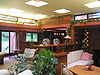
March 2, 1983 Off Quasqueton Diagonal Boulevard northwest of Quasqueton
42°24′31″N 91°46′11″W / 42.408611°N 91.769722°WQuasqueton 17 Wapsipinicon Mill 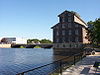
April 21, 1975 100 1st St., W.
42°28′08″N 91°53′53″W / 42.468889°N 91.898056°WIndependence 18 Wapsipinicon River Bridge 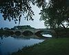
June 25, 1998 Iowa Highway 150 over the Wapsipinicon River
42°27′31″N 91°53′27″W / 42.458611°N 91.890833°WIndependence 19 Weins Commercial Building January 16, 1997 129-131 2nd Ave., NE.
42°28′11″N 91°53′37″W / 42.469722°N 91.893611°WIndependence Formerly listed
[5] Landmark name[4] Image Dates Location City or Town Summary 1 Otter Creek Bridge June 22, 2004 (delisted) Hazelton Pratt pony truss bridge built in 1870 See also
References
- ^ The latitude and longitude information provided in this table was derived originally from the National Register Information System, which has been found to be fairly accurate for about 99% of listings. For about 1% of NRIS original coordinates, experience has shown that one or both coordinates are typos or otherwise extremely far off; some corrections may have been made. A more subtle problem causes many locations to be off by up to 150 yards, depending on location in the country: most NRIS coordinates were derived from tracing out latitude and longitudes off of USGS topographical quadrant maps created under North American Datum of 1927, which differs from the current, highly accurate GPS system used by Google maps. Chicago is about right, but NRIS longitudes in Washington are higher by about 4.5 seconds, and are lower by about 2.0 seconds in Maine. Latitudes differ by about 1.0 second in Florida. Some locations in this table may have been corrected to current GPS standards.
- ^ "National Register of Historic Places: Weekly List Actions". National Park Service, United States Department of the Interior. Retrieved on November 10, 2011.
- ^ Numbers represent an ordering by significant words. Various colorings, defined here, differentiate National Historic Landmark sites and National Register of Historic Places Districts from other NRHP buildings, structures, sites or objects.
- ^ a b "National Register Information System". National Register of Historic Places. National Park Service. . http://nrhp.focus.nps.gov/natreg/docs/All_Data.html.
- ^ Numbers represent an ordering by significant words. Various colorings, defined here, differentiate National Historic Landmark sites and National Register of Historic Places Districts from other NRHP buildings, structures, sites or objects.
U.S. National Register of Historic Places Topics Lists by states Alabama • Alaska • Arizona • Arkansas • California • Colorado • Connecticut • Delaware • Florida • Georgia • Hawaii • Idaho • Illinois • Indiana • Iowa • Kansas • Kentucky • Louisiana • Maine • Maryland • Massachusetts • Michigan • Minnesota • Mississippi • Missouri • Montana • Nebraska • Nevada • New Hampshire • New Jersey • New Mexico • New York • North Carolina • North Dakota • Ohio • Oklahoma • Oregon • Pennsylvania • Rhode Island • South Carolina • South Dakota • Tennessee • Texas • Utah • Vermont • Virginia • Washington • West Virginia • Wisconsin • WyomingLists by territories Lists by associated states Other  Category:National Register of Historic Places •
  Portal:National Register of Historic Places
Municipalities and communities of Buchanan County, Iowa County seat: Independence Cities 
Townships Unincorporated
communitiesBryantsburg | Doris | Littleton | Monti | Otterville | Shady Grove
Footnotes ‡This populated place also has portions in an adjacent county or counties
Categories:- National Register of Historic Places in Iowa by county
- Buchanan County, Iowa
- Buildings and structures in Buchanan County, Iowa
-


Wikimedia Foundation. 2010.