- National Register of Historic Places listings in Box Elder County, Utah
-
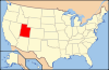
 Location of Box Elder County in Utah
This is a list of the National Register of Historic Places listings in Box Elder County, Utah.
This is intended to be a complete list of the properties and districts on the National Register of Historic Places in Box Elder County, Utah, United States. Latitude and longitude coordinates are provided for many National Register properties and districts; these locations may be seen together in a Google map.[1]
There are 44 properties and districts listed on the National Register in the county.
-
- This National Park Service list is complete through NPS recent listings posted November 10, 2011.[2]
Contents
Current listings
[3] Landmark name [4] Image Date listed Location City or town Summary 1 Martin Anderson House 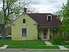
January 23, 2003 105 N. 300 West
41°30′48″N 112°01′12″W / 41.513333°N 112.02°WBrigham City 2 Bear River High School Science Building April 1, 1985 1450 S. Main St.
41°43′33″N 112°09′43″W / 41.725833°N 112.161944°WGarland 3 Box Elder County Courthouse 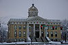
April 7, 1988 1 N. Main St.
41°30′38″N 112°00′51″W / 41.510556°N 112.014167°WBrigham City 4 Box Elder Flouring Mill 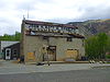
January 24, 1990 327 E. 200 North
41°30′55″N 112°00′32″W / 41.515278°N 112.008889°WBrigham City 5 Box Elder High School Gymnasium 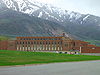
April 1, 1985 18 N. 400 East
41°30′39″N 112°00′29″W / 41.510833°N 112.008056°WBrigham City 6 Box Elder Stake Tabernacle 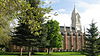
May 14, 1971 Main St. between 2nd and 3rd South Sts.
41°30′20″N 112°00′51″W / 41.505556°N 112.014167°WBrigham City 7 Brigham City Carnegie Library 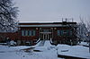
October 25, 1984 26 E. Forest St.
41°30′39″N 112°00′51″W / 41.510833°N 112.014167°WBrigham City 8 Brigham City Fire Station/City Hall 
April 7, 1988 6 N. Main St.
41°30′39″N 112°00′53″W / 41.510833°N 112.014722°WBrigham City 9 Brigham City Mercantile and Manufacturing Association Mercantile Store 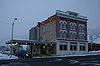
January 24, 1990 5 N. Main St.
41°30′39″N 112°00′56″W / 41.510833°N 112.015556°WBrigham City 10 Central Pacific Railroad Grade Historic District 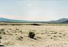
May 15, 1987 87 mile segment between the Umbria junction 9 miles east of the Nevada border, around the northern end of Great Salt Lake, to the Golden Spike National Historic Site
41°16′31″N 113°20′40″W / 41.275278°N 113.344444°WPark Valley 11 Alma Compton House 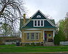
April 7, 1988 142 S. 100 East
41°30′25″N 112°00′49″W / 41.506944°N 112.013611°WBrigham City 12 Corinne Methodist Episcopal Church 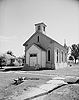
May 14, 1971 Corner of Colorado St. and 4000 West
41°32′51″N 112°06′40″W / 41.5475°N 112.111111°WCorinne 13 Cutler Hydroelectric Power Plant Historic District April 20, 1989 Off State Route 30 at the Bear River
41°50′06″N 112°03′08″W / 41.835°N 112.052222°WBeaver Dam 14 Elberta Theatre 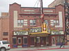
October 17, 1991 53 S. Main St.
41°30′33″N 112°00′52″W / 41.509167°N 112.014444°WBrigham City 15 Alfred and Marie Fawson House 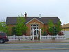
January 27, 2003 66 S. 100 West
41°30′33″N 112°01′02″W / 41.509167°N 112.017222°WBrigham City 16 Peter and Anna Christena Forsgren House 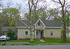
January 23, 2003 59 S. 100 East
41°30′33″N 112°00′47″W / 41.509167°N 112.013056°WBrigham City 17 Fryer Hotel April 7, 1988 3274 W. 11300 North
41°42′56″N 112°05′46″W / 41.715556°N 112.096111°WDeweyville 18 Garland Carnegie Library 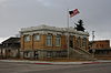
October 25, 1984 86 W. Factory St.
41°44′29″N 112°09′46″W / 41.741389°N 112.162778°WGarland 19 William and Nettie Glover House 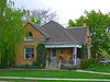
December 28, 2000 106 W. 100 North
41°30′48″N 112°01′01″W / 41.513333°N 112.016944°WBrigham City 20 Golden Spike National Historic Site 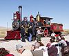
October 15, 1966 Northeast of the Great Salt Lake
41°36′31″N 112°33′20″W / 41.608611°N 112.555556°WPromontory 21 Granary of the Relief Society 
January 24, 1990 100 N. 400 East
41°30′46″N 112°00′29″W / 41.512778°N 112.008056°WBrigham City 22 Hampton's Ford Stage Stop and Barn 
August 12, 1971 Northwest of Collinston on State Route 154 at the Bear River
41°47′14″N 112°06′18″W / 41.787222°N 112.105°WCollinston 23 Hogup Cave (42BO36) 
May 8, 1986 Address Restricted[5] Park Valley 24 Holmgren Farmstead 
April 5, 2001 460 N. 300 East
41°42′59″N 112°09′31″W / 41.716389°N 112.158611°WTremonton 25 Christian and Annie Holst House 
January 27, 2003 495 S. 200 East
41°30′04″N 112°00′42″W / 41.501111°N 112.011667°WBrigham City 26 Hotel Brigham 
October 17, 1991 13 and 17 W. Forest St.
41°30′37″N 112°00′55″W / 41.510278°N 112.015278°WBrigham City 27 Howard Hotel 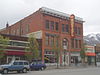
October 7, 1994 35 S. Main St.
41°30′35″N 112°00′53″W / 41.509722°N 112.014722°WBrigham City 28 Nels and Minnie Jenson House 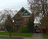
December 28, 2000 136 E. 100 South
41°30′28″N 112°00′45″W / 41.507778°N 112.0125°WBrigham City 29 Jeppson-Reeder House 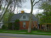
February 27, 2003 631 N. Main
41°31′25″N 112°00′55″W / 41.523611°N 112.015278°WBrigham City 30 Knudson Brothers Building 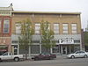
July 16, 1992 63 S. Main St.
41°30′34″N 112°00′52″W / 41.509444°N 112.014444°WBrigham City 31 Jonathan and Jennie Knudson House 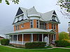
December 28, 2000 48 S. 100 East
41°30′32″N 112°00′49″W / 41.508889°N 112.013611°WBrigham City 32 Lower Bear River Archeological Discontiguous District February 13, 1986 Address Restricted[5] Brigham City 33 Mountain States Telephone and Telegraph Building 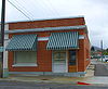
December 27, 1996 20 E. 100 South St.
41°30′28″N 112°00′52″W / 41.507778°N 112.014444°WBrigham City 34 Oregon Short Line Depot 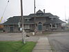
July 16, 1992 800 West and Forest St.
41°30′37″N 112°01′43″W / 41.510278°N 112.028611°WBrigham City 35 Planing Mill of Brigham City Mercantile and Manufacturing Association 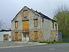
January 24, 1990 547 E. Forest St.
41°30′39″N 112°00′21″W / 41.510833°N 112.005833°WBrigham City 36 Plymouth School April 9, 1986 135 S. Main St.
41°52′31″N 112°08′45″W / 41.875278°N 112.145833°WPlymouth 37 Southern Pacific Railroad: Ogden-Lucin Cut-Off Trestle 
April 14, 1972 30 miles west of Ogden at the northern arm of the Great Salt Lake Ogden 38 A.N. Tanner House February 11, 1982 Grouse Creek
41°42′10″N 113°53′27″W / 41.702778°N 113.890833°WGrouse Creek 39 Thompson-Hansen House 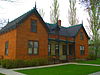
December 23, 1994 120 N. Main St.
41°30′54″N 112°00′51″W / 41.515°N 112.014167°WBrigham City 40 Transcontinental Railroad Grade December 8, 1994 Roughly from 6 miles west of Corinne running approximately 13 miles along State Route 83
41°36′55″N 112°20′40″W / 41.615278°N 112.344444°WCorinne 41 Union Block 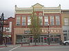
October 17, 1991 57 S. Main St.
41°30′32″N 112°00′52″W / 41.508889°N 112.014444°WBrigham City 42 Washakie LDS Ward Chapel 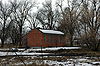
June 3, 1998 Along Samaria Lake Canal
41°56′38″N 112°13′06″W / 41.943889°N 112.218333°WWashakie 43 William L. and Mary Watkins House 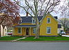
May 2, 2001 74 N. 100 East
41°30′44″N 112°00′47″W / 41.512222°N 112.013056°WBrigham City 44 Willard Historic District 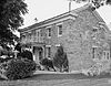
June 25, 1974 Roughly bounded by 200 West, 200 North, 100 East, and 200 South Sts.
41°24′33″N 112°02′09″W / 41.409167°N 112.035833°WWillard See also
References
- ^ The latitude and longitude information provided in this table was derived originally from the National Register Information System, which has been found to be fairly accurate for about 99% of listings. For about 1% of NRIS original coordinates, experience has shown that one or both coordinates are typos or otherwise extremely far off; some corrections may have been made. A more subtle problem causes many locations to be off by up to 150 yards, depending on location in the country: most NRIS coordinates were derived from tracing out latitude and longitudes off of USGS topographical quadrant maps created under North American Datum of 1927, which differs from the current, highly accurate GPS system used by Google maps. Chicago is about right, but NRIS longitudes in Washington are higher by about 4.5 seconds, and are lower by about 2.0 seconds in Maine. Latitudes differ by about 1.0 second in Florida. Some locations in this table may have been corrected to current GPS standards.
- ^ "National Register of Historic Places: Weekly List Actions". National Park Service, United States Department of the Interior. Retrieved on November 10, 2011.
- ^ Numbers represent an ordering by significant words. Various colorings, defined here, differentiate National Historic Landmark sites and National Register of Historic Places Districts from other NRHP buildings, structures, sites or objects.
- ^ "National Register Information System". National Register of Historic Places. National Park Service. . http://nrhp.focus.nps.gov/natreg/docs/All_Data.html.
- ^ a b Some listings on the NRHP are highly sensitive sites and may be subject to looting or vandalism. The NRHP lists this site as "Address Restricted."
External links
 Media related to National Register of Historic Places in Box Elder County, Utah at Wikimedia Commons
Properties on the National Register of Historic Places in Utah 
U.S. National Register of Historic Places Topics Lists by states Alabama • Alaska • Arizona • Arkansas • California • Colorado • Connecticut • Delaware • Florida • Georgia • Hawaii • Idaho • Illinois • Indiana • Iowa • Kansas • Kentucky • Louisiana • Maine • Maryland • Massachusetts • Michigan • Minnesota • Mississippi • Missouri • Montana • Nebraska • Nevada • New Hampshire • New Jersey • New Mexico • New York • North Carolina • North Dakota • Ohio • Oklahoma • Oregon • Pennsylvania • Rhode Island • South Carolina • South Dakota • Tennessee • Texas • Utah • Vermont • Virginia • Washington • West Virginia • Wisconsin • WyomingLists by territories Lists by associated states Other  Category:National Register of Historic Places •
  Portal:National Register of Historic Places
Municipalities and communities of Box Elder County, Utah County seat: Brigham City Cities Bear River City | Brigham City | Corinne | Garland | Honeyville | Perry | Tremonton | Willard

Towns CDPs Riverside | South Willard | Thatcher
Unincorporated
areasBothwell | Collinston | Etna | Grouse Creek | Park Valley | Penrose | Promontory | Rosette | Standrod | Yost
Ghost towns Categories:- Box Elder County, Utah
- National Register of Historic Places in Utah by county
-


Wikimedia Foundation. 2010.