- National Register of Historic Places listings in Blair County, Pennsylvania
-
 Location of Blair County in Pennsylvania
This is a list of the National Register of Historic Places listings in Blair County, Pennsylvania.
This is intended to be a complete list of the properties and districts on the National Register of Historic Places in Blair County, Pennsylvania, United States. The locations of National Register properties and districts for which the latitude and longitude coordinates are included below, may be seen in a Google map.[1]
There are 27 properties and districts listed on the National Register in the county. Two sites are further designated as National Historic Landmarks and another is designated a National Historic Site.
-
- This National Park Service list is complete through NPS recent listings posted November 10, 2011.[2]
Current listings
[3] Landmark name Image Date listed Location City or town Summary 1 Allegheny Furnace 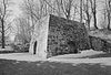
September 6, 1991 3400 Crescent Road
40°29′32″N 78°24′26″W / 40.492222°N 78.407222°WAltoona 2 Allegheny Portage Railroad National Historic Site 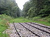
October 15, 1966 U.S. Route 22
40°27′15″N 78°32′25″W / 40.45417°N 78.54028°WAllegheny Township Extends into Conemaugh and Cresson Townships in Cambria County 3 Altoona Armory May 9, 1991 327 Frankstown Road
40°28′53″N 78°23′50″W / 40.481389°N 78.397222°WLogan Township 4 Baker Mansion June 5, 1975 3500 Baker Boulevard
40°29′26″N 78°24′30″W / 40.490556°N 78.408333°WAltoona 5 Birmingham Bridge 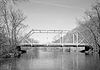
March 20, 1990 Over the Juniata River, north of Birmingham off Pennsylvania Route 350
40°38′56″N 78°11′57″W / 40.648889°N 78.199167°WTyrone Township Extends into Warriors Mark Township in Huntingdon County 6 Blair County Courthouse 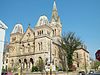
June 17, 1976 423 Allegheny Street
40°25′49″N 78°23′33″W / 40.430278°N 78.3925°WHollidaysburg 7 Broad Avenue Historic District July 25, 2002 Roughly along Broad Avenue, from 23rd to 31st Streets
40°30′08″N 78°24′46″W / 40.502222°N 78.412778°WAltoona 8 Central Trust Company Buildings 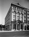
November 1, 1984 1210–1218 11th Avenue
40°30′55″N 78°24′06″W / 40.5152°N 78.401656°WAltoona 9 Downtown Altoona Historic District 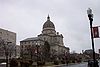
None Roughly bounded by 11th Avenue, 11th Street, 15th Avenue and 13th Street, also 700–1000 Lexington and 900–1000 Howard Avenues
40°31′08″N 78°24′04″W / 40.518889°N 78.401111°WAltoona 10 Etna Furnace 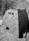
None North of Williamsburg: roughly the area south and east of the bend of the Frankstown Branch Juniata River at Mount Etna
40°31′34″N 78°11′11″W / 40.526111°N 78.186389°WCatharine Township Specific boundaries represent a boundary increase of September 6, 1991 11 Fort Roberdeau 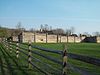
May 29, 1974 West of Culp off U.S. Route 220
40°34′57″N 78°16′26″W / 40.5825°N 78.273889°WTyrone Township 12 Highland Hall 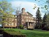
September 13, 1978 517 Walnut Street
40°25′55″N 78°23′32″W / 40.431944°N 78.392222°WHollidaysburg 13 Hollidaysburg Historic District 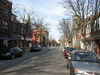
December 26, 1985 Roughly bounded by Spruce, Bella, Blair, and Juniata Streets
40°25′48″N 78°23′29″W / 40.43°N 78.391389°WHollidaysburg 14 Horseshoe Curve 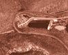
November 13, 1966 5 miles (8.0 km) west of Altoona on Pennsylvania Route 193
40°29′51″N 78°28′54″W / 40.4975°N 78.481667°WLogan Township 15 Jacob Isett House and Store March 28, 1997 Legislative Route 1013, 0.3 miles (0.5 km) south of junction with Legislative Route 1015
40°36′16″N 78°12′25″W / 40.604444°N 78.206944°WTyrone Township 16 Knickerbocker Historic District 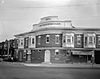
February 20, 2002 4th, 5th and 6th Avenues, Burgoon Road, 40th and 41st Streets
40°29′11″N 78°24′50″W / 40.486389°N 78.413889°WAltoona 17 Leap-the-Dips 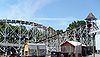
March 15, 1991 700 Park Avenue
40°28′15″N 78°23′48″W / 40.470833°N 78.396667°WLogan Township 18 Llyswen Historic District 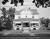
July 25, 2002 Coleridge, Logan, Aldrich bounded by Mill Run and Ward
40°28′59″N 78°24′25″W / 40.483056°N 78.406944°WAltoona 19 Mishler Theatre 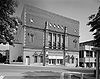
April 11, 1973 1208 12th Avenue
40°32′02″N 78°24′04″W / 40.533889°N 78.401111°WAltoona 20 J.L. Noble School July 11, 1996 209 12th Avenue, Juniata
40°32′16″N 78°23′35″W / 40.537778°N 78.393056°WAltoona 21 Penn Alto Hotel 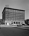
May 5, 1989 12th Street and 13th Avenue
40°31′01″N 78°24′09″W / 40.516944°N 78.4025°WAltoona 22 Roaring Spring Historic District 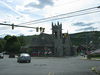
March 3, 1995 Roughly bounded by Barley, Lower, Walnut, Roosevelt, California, Hickory, Fairview, Sugar and North Main Streets
40°20′05″N 78°23′56″W / 40.334722°N 78.398889°WRoaring Spring 23 Daniel Royer House November 3, 1975 5 miles (8.0 km) southwest of Williamsburg on Pennsylvania Route 866
40°25′25″N 78°16′13″W / 40.423611°N 78.270278°WWoodbury Township 24 St. John's Evangelical Lutheran Church September 18, 1978 Sinking Valley on Old Water Street Road Northeast of Culp
40°35′39″N 78°15′01″W / 40.594167°N 78.250278°WTyrone Township 25 Tyrone Armory 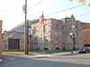
December 22, 1989 956 South Logan Avenue
40°40′11″N 78°14′25″W / 40.669722°N 78.240278°WTyrone 26 Tyrone Borough Historic District 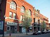
January 21, 1993 Roughly bounded by West 14th Street, Logan Avenue, Bald Eagle Avenue, the Little Juniata River, West 8th Street and Jefferson Avenue
40°40′19″N 78°14′26″W / 40.671944°N 78.240556°WTyrone 27 Williamsburg Historic District May 12, 1995 Approximately 30 square blocks centered around Second and High Streets
40°27′39″N 78°12′14″W / 40.460833°N 78.203889°WWilliamsburg See also
- List of National Historic Landmarks in Pennsylvania
- National Register of Historic Places listings in Pennsylvania
- List of Pennsylvania state historical markers in Blair County
References
- ^ The latitude and longitude information provided in this table was derived originally from the National Register Information System, which has been found to be fairly accurate for about 99% of listings. For about 1% of NRIS original coordinates, experience has shown that one or both coordinates are typos or otherwise extremely far off; some corrections may have been made. A more subtle problem causes many locations to be off by up to 150 yards, depending on location in the country: most NRIS coordinates were derived from tracing out latitude and longitudes off of USGS topographical quadrant maps created under the North American Datum of 1927, which differs from the current, highly accurate WGS84 GPS system used by Google maps. Chicago is about right, but NRIS longitudes in Washington are higher by about 4.5 seconds, and are lower by about 2.0 seconds in Maine. Latitudes differ by about 1.0 second in Florida. Some locations in this table may have been corrected to current GPS standards.
- ^ "National Register of Historic Places: Weekly List Actions". National Park Service, United States Department of the Interior. Retrieved on November 10, 2011.
- ^ Numbers represent an ordering by significant words. Various colorings, defined here, differentiate National Historic Landmark sites and National Register of Historic Places Districts from other NRHP buildings, structures, sites or objects.
Municipalities and communities of Blair County, Pennsylvania City 
Boroughs Bellwood | Duncansville | Hollidaysburg | Martinsburg | Newry | Roaring Spring | Tunnelhill‡ | Tyrone | Williamsburg
Townships CDPs Unincorporated
communityFootnotes ‡This populated place also has portions in an adjacent county or counties
Categories:- National Register of Historic Places in Pennsylvania by county
- Blair County, Pennsylvania
-


Wikimedia Foundation. 2010.