- National Register of Historic Places listings in Big Stone County, Minnesota
-
 Location of Big Stone County in Minnesota
This is a list of the National Register of Historic Places listings in Big Stone County, Minnesota. It is intended to be a complete list of the properties and districts on the National Register of Historic Places in Beltrami County, Minnesota, United States. The locations of National Register properties and districts for which the latitude and longitude coordinates are included below, may be seen in a Google map.[1]
There are 9 properties and districts listed on the National Register in the county.
-
- This National Park Service list is complete through NPS recent listings posted November 10, 2011.[2]
Listings county-wide
[3] Landmark name Image Date listed Location City or town Summary 1 Big Stone County Courthouse August 15, 1985 20 2nd St., SE.
45°18′16″N 96°26′38″W / 45.304444°N 96.443889°WOrtonville 2 Chicago, Milwaukee, St. Paul and Pacific Depot July 31, 1986 Main and Center Sts.
45°27′35″N 96°26′14″W / 45.459722°N 96.437222°WClinton 3 Columbian Hotel August 15, 1985 305 2nd St., NW.
45°18′26″N 96°26′52″W / 45.307222°N 96.447778°WOrtonville 4 District No. 13 School 
August 15, 1985 County Road 25
45°20′55″N 96°09′30″W / 45.348611°N 96.158333°WCorrell 5 Graceville Historical Marker December 15, 2004 Minnesota Highway 15
45°34′05″N 96°27′00″W / 45.568056°N 96.45°WGraceville 6 Odessa Jail July 24, 1986 Main and 2nd Sts.
45°15′36″N 96°19′44″W / 45.26°N 96.328889°WOdessa 7 Ortonville Commercial Historic District August 15, 1985 2nd St., Madison and Monroe Aves., between Jefferson and Jackson Aves.
45°18′21″N 96°26′45″W / 45.305833°N 96.445833°WOrtonville 8 Ortonville Free Library August 15, 1985 412 2nd St., NW.
45°18′31″N 96°26′52″W / 45.308611°N 96.447778°WOrtonville 9 St. Pauli Norwegian Evangelical Lutheran Church 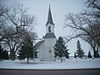
August 26, 2010 33022 U.S. Route 75
45°25′35″N 96°25′51″W / 45.426389°N 96.430833°WAlmond Township vicinity See also
- List of National Historic Landmarks in Minnesota
- National Register of Historic Places listings in Minnesota
References
- ^ The latitude and longitude information provided in this table was derived originally from the National Register Information System, which has been found to be fairly accurate for about 99% of listings. For about 1% of NRIS original coordinates, experience has shown that one or both coordinates are typos or otherwise extremely far off; some corrections may have been made. A more subtle problem causes many locations to be off by up to 150 yards, depending on location in the country: most NRIS coordinates were derived from tracing out latitude and longitudes off of USGS topographical quadrant maps created under the North American Datum of 1927, which differs from the current, highly accurate WGS84 GPS system used by Google maps. Chicago is about right, but NRIS longitudes in Washington are higher by about 4.5 seconds, and are lower by about 2.0 seconds in Maine. Latitudes differ by about 1.0 second in Florida. Some locations in this table may have been corrected to current GPS standards.
- ^ "National Register of Historic Places: Weekly List Actions". National Park Service, United States Department of the Interior. Retrieved on November 10, 2011.
- ^ Numbers represent an ordering by significant words. Various colorings, defined here, differentiate National Historic Landmark sites and National Register of Historic Places Districts from other NRHP buildings, structures, sites or objects.
U.S. National Register of Historic Places Topics Lists by states Alabama • Alaska • Arizona • Arkansas • California • Colorado • Connecticut • Delaware • Florida • Georgia • Hawaii • Idaho • Illinois • Indiana • Iowa • Kansas • Kentucky • Louisiana • Maine • Maryland • Massachusetts • Michigan • Minnesota • Mississippi • Missouri • Montana • Nebraska • Nevada • New Hampshire • New Jersey • New Mexico • New York • North Carolina • North Dakota • Ohio • Oklahoma • Oregon • Pennsylvania • Rhode Island • South Carolina • South Dakota • Tennessee • Texas • Utah • Vermont • Virginia • Washington • West Virginia • Wisconsin • WyomingLists by territories Lists by associated states Other Municipalities and communities of Big Stone County, Minnesota Cities Barry | Beardsley | Clinton | Correll | Graceville | Johnson | Odessa | Ortonville‡

Townships Akron | Almond | Artichoke | Big Stone | Browns Valley | Foster | Graceville | Malta | Moonshine | Odessa | Ortonville | Otrey | Prior | Toqua
Footnotes ‡This populated place also has portions in an adjacent county or counties
Categories:- National Register of Historic Places in Minnesota by county
- Big Stone County, Minnesota
- Buildings and structures in Big Stone County, Minnesota
-


Wikimedia Foundation. 2010.