- National Register of Historic Places listings in Allen County, Ohio
-
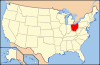
 Location of Allen County in Ohio
This is a list of the National Register of Historic Places listings in Allen County, Ohio.
This is intended to be a complete list of the properties and districts on the National Register of Historic Places in Allen County, Ohio, United States. The locations of National Register properties and districts for which the latitude and longitude coordinates are included below, may be seen in a Google map.[1]
There are 30 properties and districts listed on the National Register in the county, including 1 National Historic Landmark. Another 2 properties were once listed but have been removed.
-
- This National Park Service list is complete through NPS recent listings posted November 10, 2011.[2]
Current listings
[3] Landmark name [4] Image Date listed Location City or town Summary 1 Adgate Block 
October 7, 1982 300-306 S. Main St.
40°44′13″N 84°06′20″W / 40.736944°N 84.105556°WLima Demolished and replaced with a YMCA 2 Allen County Courthouse 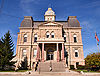
July 24, 1974 Courthouse Sq.
40°44′34″N 84°06′20″W / 40.742778°N 84.105556°WLima 3 Armory-Latisona Building 
October 7, 1982 440 S. Main St.
40°44′06″N 84°06′19″W / 40.735°N 84.105278°WLima 4 Barr Hotel 
May 15, 1986 201-209 E. High and 200-218 N. Union Sts.
40°44′16″N 84°06′11″W / 40.737778°N 84.103056°WLima 5 Griffith Breese Farm 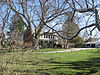
January 11, 1983 2875 Fort Amanda Rd., southwest of Lima
40°42′18″N 84°09′20″W / 40.704889°N 84.155556°WShawnee Township 6 Beck and R.C. Cahill Buildings 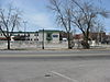
October 7, 1982 200-206 S. Main St.
40°44′19″N 84°06′19″W / 40.738611°N 84.105278°WLima Demolished and replaced with a parking lot 7 Dorsey Building 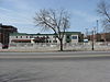
October 7, 1982 208 S. Main St.
40°44′16″N 84°06′20″W / 40.737778°N 84.105556°WLima Demolished and replaced with a parking lot 8 Elks Lodge 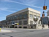
October 7, 1982 138 W. North St.
40°44′35″N 84°06′23″W / 40.743056°N 84.106389°WLima 9 First National Bank and Trust Building 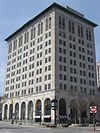
October 7, 1982 43-53 Public Sq.
40°44′24″N 84°06′20″W / 40.74°N 84.105556°WLima 10 Hotel Argonne 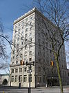
October 7, 1982 201 N. Elizabeth St.
40°44′29″N 84°06′25″W / 40.741389°N 84.106944°WLima 11 Klaus Block 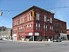
October 7, 1982 401-405 N. Main St.
40°44′39″N 84°06′19″W / 40.744167°N 84.105278°WLima 12 Lima Cleaning and Pressing Company 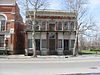
October 7, 1982 436-438 S. Main St.
40°44′07″N 84°06′19″W / 40.735278°N 84.105278°WLima 13 Lima Memorial Hall 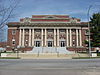
May 7, 1979 W. Elm and S. Elizabeth Sts.
40°44′15″N 84°06′23″W / 40.7375°N 84.106389°WLima 14 Lima Pennsylvania Railroad Passenger Depot 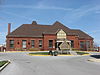
August 21, 2003 424 N. Central Ave.
40°44′42″N 84°06′07″W / 40.745°N 84.101944°WLima 15 Lima Stadium 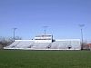
March 21, 2002 100 S. Calument Ave. and E. Market St.
40°44′23″N 84°05′32″W / 40.739722°N 84.092222°WLima 16 Linneman Building 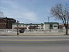
October 7, 1982 210-212 S. Main St.
40°44′15″N 84°06′20″W / 40.7375°N 84.105556°WLima Demolished and replaced with a parking lot 17 MacDonell House 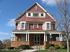
September 20, 1978 632 W. Market St.
40°44′25″N 84°06′58″W / 40.740278°N 84.116111°WLima 18 Marks-Family House 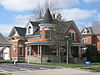
April 1, 1982 233 N. Franklin St.
40°50′39″N 84°20′14″W / 40.844167°N 84.337222°WDelphos 19 Martin Block and Kibby Block 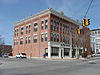
October 7, 1982 140-146 S. Main St.
40°44′19″N 84°06′19″W / 40.738611°N 84.105278°WLima 20 Metropolitan Block 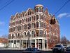
November 29, 1979 300 N. Main St.
40°44′34″N 84°06′16″W / 40.742778°N 84.104444°WLima 21 Miami and Erie Canal Deep Cut 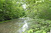
October 15, 1966 2 mi (3.2 km) south of Spencerville on State Route 66
40°41′06″N 84°21′57″W / 40.68497°N 84.36575°WSpencer Township Extends into Salem Township in Auglaize County 22 Neal Clothing 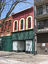
October 7, 1982 74 Public Sq.
40°44′26″N 84°06′17″W / 40.740556°N 84.104722°WLima 23 Neely-Sieber House 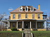
December 12, 1976 620 W. Spring St.
40°44′19″N 84°06′52″W / 40.738611°N 84.114444°WLima 24 Ohio Theatre 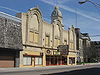
October 7, 1982 122 W. North St.
40°44′34″N 84°06′22″W / 40.742778°N 84.106111°WLima 25 Renz Block 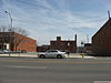
October 7, 1982 320 N. Main St.
40°44′36″N 84°06′18″W / 40.743333°N 84.105°WLima Demolished and replaced with a parking lot 26 Round Barn 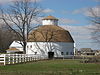
April 17, 1980 Along East Rd., south of Elida
40°46′26″N 84°11′25.38″W / 40.77389°N 84.1903833°W[5]American Township 27 St. John Catholic Church 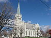
January 3, 1980 110 N. Franklin St.
40°50′35″N 84°20′10″W / 40.843056°N 84.336111°WDelphos 28 U.S. Post Office 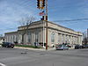
October 7, 1982 326 W. High St.
40°44′29″N 84°06′32″W / 40.741389°N 84.108889°WLima 29 Union Block 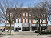
October 7, 1982 28-38 Public Sq.
40°44′23″N 84°06′17″W / 40.739722°N 84.104722°WLima 30 West Market Street Boulevard Historic District 
October 27, 2004 1410-1529 W. Market St.
40°44′24″N 84°08′04″W / 40.74°N 84.134417°WLima Former listings
[3] Landmark name Image Date listed Location City or town Summary 1 Round Barn May 5, 1983 Along U.S. Route 30, east of Delphos Delphos 2 Wheeler Building 
July 12, 1985 131-135 W. Market St.
40°44′23.2″N 84°6′22.8″W / 40.739778°N 84.106333°WLima See also
References
- ^ The latitude and longitude information provided in this table was derived originally from the National Register Information System, which has been found to be fairly accurate for about 99% of listings. For about 1% of NRIS original coordinates, experience has shown that one or both coordinates are typos or otherwise extremely far off; some corrections may have been made. A more subtle problem causes many locations to be off by up to 150 yards, depending on location in the country: most NRIS coordinates were derived from tracing out latitude and longitudes off of USGS topographical quadrant maps created under the North American Datum of 1927, which differs from the current, highly accurate WGS84 GPS system used by Google maps. Chicago is about right, but NRIS longitudes in Washington are higher by about 4.5 seconds, and are lower by about 2.0 seconds in Maine. Latitudes differ by about 1.0 second in Florida. Some locations in this table may have been corrected to current GPS standards.
- ^ "National Register of Historic Places: Weekly List Actions". National Park Service, United States Department of the Interior. Retrieved on November 10, 2011.
- ^ a b Numbers represent an ordering by significant words. Various colorings, defined here, differentiate National Historic Landmark sites and National Register of Historic Places Districts from other NRHP buildings, structures, sites or objects.
- ^ "National Register Information System". National Register of Historic Places. National Park Service. . http://nrhp.focus.nps.gov/natreg/docs/All_Data.html.
- ^ Location derived from its Multiple Property Submission; the NRIS lists its specific location as "Address Restricted"
National Register of Historic Places in Ohio Lists by county Adams • Allen • Ashland • Ashtabula • Athens • Auglaize • Belmont • Brown • Butler • Carroll • Champaign • Clark • Clermont • Clinton • Columbiana • Coshocton • Crawford • Cuyahoga • Darke • Defiance • Delaware • Erie • Fairfield • Fayette • Franklin • Fulton • Gallia • Geauga • Greene • Guernsey • Hamilton • Hancock • Hardin • Harrison • Henry • Highland • Hocking • Holmes • Huron • Jackson • Jefferson • Knox • Lake • Lawrence • Licking • Logan • Lorain • Lucas • Madison • Mahoning • Marion • Medina • Meigs • Mercer • Miami • Monroe • Montgomery • Morgan • Morrow • Muskingum • Noble • Ottawa • Paulding • Perry • Pickaway • Pike • Portage • Preble • Putnam • Richland • Ross • Sandusky • Scioto • Seneca • Shelby • Stark • Summit • Trumbull • Tuscarawas • Union • Van Wert • Vinton • Warren • Washington • Wayne • Williams • Wood • Wyandot
Lists by city Other lists Municipalities and communities of Allen County, Ohio Cities 
Villages Beaverdam | Bluffton‡ | Cairo | Elida | Ft. Shawnee | Harrod | Lafayette | Spencerville
Townships Unincorporated
communitiesFootnotes ‡This populated place also has portions in an adjacent county or counties
Categories:- National Register of Historic Places in Ohio by county
- Allen County, Ohio
-


Wikimedia Foundation. 2010.