- National Register of Historic Places listings in Allamakee County, Iowa
-
 Location of Allamakee County in Iowa
This is a list of the National Register of Historic Places listings in Allamakee County, Iowa.
This is intended to be a complete list of the properties and districts on the National Register of Historic Places in Allamakee County, Iowa, United States. Latitude and longitude coordinates are provided for many National Register properties and districts; these locations may be seen together in a Google map.[1]
There are 19 properties and districts listed on the National Register in the county.
-
- This National Park Service list is complete through NPS recent listings posted November 10, 2011.[2]
[3] Landmark name [4] Image Date listed Location City or town Summary 1 Allamakee County Court House 
August 28, 2003 110 Allamakee St.
43°16′13″N 91°28′32″W / 43.270278°N 91.475556°WWaukon 2 Allamakee County Courthouse 
April 11, 1977 107 Allamakee St.
43°16′15″N 91°28′31″W / 43.270833°N 91.475278°WWaukon 3 Effigy Mounds National Monument 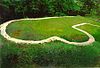
October 15, 1966 3 miles north of Marquette on Iowa Highway 76
43°05′33″N 91°11′46″W / 43.09237°N 91.19614°WMarquette Extends into Clayton County 4 Fish Farm Mound Group July 25, 1988 Address Restricted New Albin 5 Otto J. Hager House June 27, 1985 402 Allamakee St.
43°16′22″N 91°28′20″W / 43.272778°N 91.472222°WWaukon 6 Iron Post September 29, 1976 Northern end of Main St.
43°30′03″N 91°16′59″W / 43.500833°N 91.283056°WNew Albin 7 G. Kerndt and Brothers Elevator and Warehouses, No. 11, No.12 and No. 13 October 18, 1979 Front St.
43°21′33″N 91°13′20″W / 43.359167°N 91.222222°WLansing 8 G. Kerndt & Brothers Office Block November 10, 1982 4th and Main Sts.
43°21′36″N 91°13′09″W / 43.36°N 91.219167°WLansing 9 Lansing Fisheries Building December 23, 1991 Between County Highway X-52 and the Mississippi River in southern Lansing
43°21′38″N 91°12′48″W / 43.360556°N 91.213333°WLansing 10 Lansing Stone School December 18, 1973 Southwestern corner of Center and 5th Sts.
43°21′38″N 91°13′16″W / 43.360556°N 91.221111°WLansing 11 Fred W. Meier Round Barn 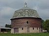
June 30, 1986 Off Iowa Highway 9
43°14′03″N 91°28′34″W / 43.234167°N 91.476111°WLudlow 12 Monsrud Bridge June 25, 1998 Swebakken Rd. over Paint Creek
43°13′09″N 91°19′36″W / 43.219167°N 91.326667°WWaterville 13 Old Allamakee County Courthouse February 24, 1983 2nd St.
43°21′35″N 91°13′05″W / 43.359722°N 91.218056°WLansing 14 Old East Paint Creek Lutheran Church July 7, 1983 North of Waterville on County Road A-52
43°15′52″N 91°16′11″W / 43.264444°N 91.269722°WWaterville 15 Thomas Reburn Polygonal Barn June 30, 1986 Off Iowa Highway 26
43°29′32″N 91°18′11″W / 43.492222°N 91.303056°WNew Albin 16 Red Bridge 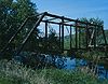
June 25, 1998 Fuel Hollow Rd. over the Yellow River
43°07′51″N 91°25′28″W / 43.130833°N 91.424444°WPostville 17 Slinde Mound Group November 1, 1989 Address Restricted Hanover Township 18 Turner Hall 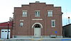
December 11, 2000 119 East Greene Street
43°05′05″N 91°34′30″W / 43.084722°N 91.575°WPostville 19 Upper Iowa River Bridge June 25, 1998 Mays Prairie Rd. over the Upper Iowa River
43°25′57″N 91°24′43″W / 43.4325°N 91.411944°WDorchester See also
References
- ^ The latitude and longitude information provided in this table was derived originally from the National Register Information System, which has been found to be fairly accurate for about 99% of listings. For about 1% of NRIS original coordinates, experience has shown that one or both coordinates are typos or otherwise extremely far off; some corrections may have been made. A more subtle problem causes many locations to be off by up to 150 yards, depending on location in the country: most NRIS coordinates were derived from tracing out latitude and longitudes off of USGS topographical quadrant maps created under the North American Datum of 1927, which differs from the current, highly accurate WGS84 GPS system used by Google maps. Chicago is about right, but NRIS longitudes in Washington are higher by about 4.5 seconds, and are lower by about 2.0 seconds in Maine. Latitudes differ by about 1.0 second in Florida. Some locations in this table may have been corrected to current GPS standards.
- ^ "National Register of Historic Places: Weekly List Actions". National Park Service, United States Department of the Interior. Retrieved on November 10, 2011.
- ^ Numbers represent an ordering by significant words. Various colorings, defined here, differentiate National Historic Landmark sites and National Register of Historic Places Districts from other NRHP buildings, structures, sites or objects.
- ^ "National Register Information System". National Register of Historic Places. National Park Service. . http://nrhp.focus.nps.gov/natreg/docs/All_Data.html.
U.S. National Register of Historic Places Topics Lists by states Alabama • Alaska • Arizona • Arkansas • California • Colorado • Connecticut • Delaware • Florida • Georgia • Hawaii • Idaho • Illinois • Indiana • Iowa • Kansas • Kentucky • Louisiana • Maine • Maryland • Massachusetts • Michigan • Minnesota • Mississippi • Missouri • Montana • Nebraska • Nevada • New Hampshire • New Jersey • New Mexico • New York • North Carolina • North Dakota • Ohio • Oklahoma • Oregon • Pennsylvania • Rhode Island • South Carolina • South Dakota • Tennessee • Texas • Utah • Vermont • Virginia • Washington • West Virginia • Wisconsin • WyomingLists by territories Lists by associated states Other Municipalities and communities of Allamakee County, Iowa Cities Harpers Ferry | Lansing | New Albin | Postville‡ | Waterville | Waukon

Townships Center | Fairview | Franklin | French Creek | Hanover | Iowa | Jefferson | Lafayette | Lansing | Linton | Ludlow | Makee | Paint Creek | Post | Taylor | Union City | Union Prairie | Waterloo
Unincorporated
communityFootnotes ‡This populated place also has portions in an adjacent county or counties
Categories:- National Register of Historic Places in Iowa by county
- Allamakee County, Iowa
- Buildings and structures in Allamakee County, Iowa
-


Wikimedia Foundation. 2010.