- National Register of Historic Places listings in Adair County, Kentucky
-
 Location of Adair County in Kentucky
This is a list of the National Register of Historic Places listings in Adair County, Kentucky.
It is intended to be a complete list of the properties on the National Register of Historic Places in Adair County, Kentucky, United States. The locations of National Register properties for which the latitude and longitude coordinates are included below, may be seen in a Google map.[1]
There are 9 properties listed on the National Register in the county.
-
- This National Park Service list is complete through NPS recent listings posted November 10, 2011.[2]
Current listings
[3] Landmark name Image Date listed Location City or town Summary 1 Adair County Courthouse 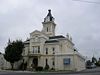
August 27, 1974 500 Public Sq.
37°06′10″N 85°18′22″W / 37.102778°N 85.306111°WColumbia 2 Archeological Site 15 Ad 33 December 8, 1978 Address Restricted Columbia 3 Archeological Site 15 Ad 36 November 16, 1978 Address Restricted Glens Fork 4 Archeological Site 15 Ad 54 November 16, 1978 Address Restricted Columbia 5 John Field House February 8, 1978 111 E. Fortune St.
37°06′05″N 85°18′23″W / 37.101389°N 85.306389°WColumbia 6 Dr. Nathan Gaither House March 21, 1979 100 S. High St.
37°06′14″N 85°18′27″W / 37.103889°N 85.3075°WColumbia 7 Janice Holt and Henry Giles Log House November 6, 1997 302 Spout Springs Rd.
37°12′17″N 85°08′52″W / 37.204722°N 85.147778°WKnifley 8 Daniel Trabue House December 16, 1974 299 Jamestown St.
37°06′00″N 85°18′13″W / 37.1°N 85.303611°WColumbia 9 Zion Meetinghouse and School May 13, 1976 Southeast of Columbia on KY 55
37°03′02″N 85°15′44″W / 37.050556°N 85.262222°WColumbia See also
- List of National Historic Landmarks in Kentucky
- National Register of Historic Places listings in Kentucky
References
- ^ The latitude and longitude information provided in this table was derived originally from the National Register Information System, which has been found to be fairly accurate for about 99% of listings. For about 1% of NRIS original coordinates, experience has shown that one or both coordinates are typos or otherwise extremely far off; some corrections may have been made. A more subtle problem causes many locations to be off by up to 150 yards, depending on location in the country: most NRIS coordinates were derived from tracing out latitude and longitudes off of USGS topographical quadrant maps created under the North American Datum of 1927, which differs from the current, highly accurate WGS84 GPS system used by Google maps. Chicago is about right, but NRIS longitudes in Washington are higher by about 4.5 seconds, and are lower by about 2.0 seconds in Maine. Latitudes differ by about 1.0 second in Florida. Some locations in this table may have been corrected to current GPS standards.
- ^ "National Register of Historic Places: Weekly List Actions". National Park Service, United States Department of the Interior. Retrieved on November 10, 2011.
- ^ Numbers represent an ordering by significant words. Various colorings, defined here, differentiate National Historic Landmark sites and National Register of Historic Places Districts from other NRHP buildings, structures, sites or objects.
U.S. National Register of Historic Places Topics Lists by states Alabama • Alaska • Arizona • Arkansas • California • Colorado • Connecticut • Delaware • Florida • Georgia • Hawaii • Idaho • Illinois • Indiana • Iowa • Kansas • Kentucky • Louisiana • Maine • Maryland • Massachusetts • Michigan • Minnesota • Mississippi • Missouri • Montana • Nebraska • Nevada • New Hampshire • New Jersey • New Mexico • New York • North Carolina • North Dakota • Ohio • Oklahoma • Oregon • Pennsylvania • Rhode Island • South Carolina • South Dakota • Tennessee • Texas • Utah • Vermont • Virginia • Washington • West Virginia • Wisconsin • WyomingLists by territories Lists by associated states Other Municipalities and communities of Adair County, Kentucky City 
Unincorporated
communitiesAbsher | Barnett Springs | Bliss | Breeding | Cane Valley | Casey Creek | Chance | Christine | Coburg | Craycraft | Crocus‡ | Cundiff | Dunbar Hill | Ella | Eunice | Fairplay | Feathersburg | Flatwood | Gadberry | Garlin | Gentrys Mill | Glens Fork | Gradyville | Holmes | Inroad | Joppa | Kellyville | Keltner | Knifley | Milltown | Montpelier | Neatsville | Nell | Ozark | Pellyton | Pickett | Portland | Purdy | Sparksville | Toria | Weed
Footnotes ‡This populated place also has portions in an adjacent county or counties.
Categories:- National Register of Historic Places in Kentucky by county
- Adair County, Kentucky
-


Wikimedia Foundation. 2010.