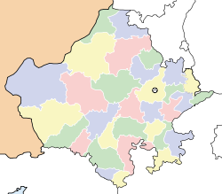
- Nasirabad, Ajmer
-
Nasirabad
नसिराबाद ناصر آباد— city — Coordinates 26°18′N 74°44′E / 26.3°N 74.73°ECoordinates: 26°18′N 74°44′E / 26.3°N 74.73°E Country India State Rajasthan District(s) Ajmer MLA Mahendra Singh Gurjar Population 49,111 (2001[update]) Time zone IST (UTC+05:30) Area
• 429 metres (1,407 ft)
Codes-
• Pincode • 305601 • Vehicle • RJ-01
This article is about a town in India. For other uses, see Nasirabad.Nasirabad (Hindi: नसिराबाद, Urdu: ناصر آباد) is a cantonment town in Ajmer district in the Indian state of Rajasthan.
Contents
History
The name is based on a famous English officer (Sir David Ochterlony), who was honoured with the name "NASIR-UD-DAULA" (the Defender of the State), by Mughal Badshah Shah Alam II. The city is known for its Army population. Many soldiers and officers are posted here every year. Also, this is the second station in Rajputana, after Beawer, where missionary work started in 1860's during the epidemic of Plague. Nasirabad is known as a chhavani in Ajmer.
Demographics
As of 2001[update] India census[1], Nasirabad had a population of 49,111. Males constitute 58% of the population and females 42%. Nasirabad has an average literacy rate of 75%, higher than the national average of 59.5%: male literacy is 84%, and female literacy is 64%. In Nasirabad, 13% of the population is under 6 years of age.It is surrounded by the Aravali ranges.
Overview
This city has a significance for the Indian Army. Nasirabad Cantonment has one of the biggest firing range in India. The army has almost surrounded this town. As far as the security is concerned this is one of the safest place available in Rajasthan due to the presence of the Indian Army. The way this city has grown is awesome. People from different states of India have been interacting with the local population. The Indian army again plays an important role in this activity. This is one of the most famous place in Rajasthan where the 1857 revolt erupted. This was the place which represented Rajasthan in this mutiny.
The city is surrounded with Ajmer, Beawer, and Kishangarh. The GAIL has made this an important place. The largest Gas Plant in Asia is situated in Dilwara, Nasirabad. With the development of this Gas Plant ample of opportunities have raised. Transportation system is a vital player in this as the transportation of Gas and Petroleum products is a necessary activity with this.
Nasirabad is a charming, little town where you will still find horse-drawn carts,horse driven people carrier called Tonga, home-based oil-pressers, and small-time jewellers catering to the neighbouring villages. The main city market is known as Sadar Bazar. The city is a important hub for neighbouring villages. Farmers bring their produce at the local food market (Subji Mandi) for selling. There is a famous eatable known as Kachora, available. This is a round shaped fried chapati with an abnormal size. A Kachora normally weighs 500 to 600 grams. This is full of spices and is one of the most famous mouth watering eatable. The Halwai or the one who prepares these Kachoras is Chawanni Lal Halwai. Kachora is widely appreciated as a morning snack and people come from far-off places to eat it.Kachora is made of lentil (Dal)and potato. Shelf life of potato one is very short. Other old time market is called Ganj or in otherwords, anaaj mandi, hindi for grain market. Smt. Krishna Kumari is a lady who was awarded by Prime Minister of that time Shri Chandra Shekhar in the year 1991 for her best services in Guide. Param Vir Chakra Abdul Hamid was under training as a soldier when our war broke out with Pakistan in 1965. He was sent to the front and destroyed USA's Patton Tanks numbering 8-10 single handed and died setting an example of etreme bravery. Another high point of Nasirabad Cantt is that former Prime Minister Zulfikar Ali Bhotto was first commissioned in the army. Lastly tbe Band of Grenadiers Regimental Centre is sent to Delhi in ceremonial parades.
Education
Kendriya Vidyalaya Sangathan has achieved highest ratio of passed students for last decades for tenth & twelfth standard board Examinations. Other CBSE schools are: Army School, St. Johns, Ravindra Public Secondary School, etc.
Transportation
Nasirabad Cantonment is well connected with railways (Broad Gauge of Indian Railways) and also connected with Golden Quadrilateral of Delhi - Mumbai route. Closest Airport is Sanganer Airport, Jaipur which is around 135km from the city. There are two bus stations from where Rajasthan Public Transport Buses ply to every major town and city in Rajasthan. Nasirabad has largest number of trailer owners in India.
References
- ^ "Census of India 2001: Data from the 2001 Census, including cities, villages and towns (Provisional)". Census Commission of India. Archived from the original on 2004-06-16. http://web.archive.org/web/20040616075334/http://www.censusindia.net/results/town.php?stad=A&state5=999. Retrieved 2008-11-01.
Ajmer Ajmer · Kekri · Kiranipura · Kishangarh · Nasirabad · Pushkar · Sarwar · Vijainagar
Cities and towns
in other districtsAlwar · Banswara · Baran · Barmer · Beawar · Bharatpur · Bhilwara · Bikaner · Bundi · Chittorgarh · Churu · Dausa · Dholpur · Dungarpur · Hanumangarh · Jaipur · Jaisalmer · Jalore · Jhalawar · Jhunjhunu · Jodhpur · Karauli · Kota · Nagaur · Pali · Pratapgarh · Rajsamand · Sawai Madhopur · Sikar · Sirohi · Sri Ganganagar · Tonk · Udaipur
Categories:- Cities and towns in Ajmer district
- Cantonments of India
- Cantonments of British India
- Places of Indian Rebellion of 1857
- Rajasthan geography stubs
-
Wikimedia Foundation. 2010.


