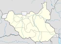
- Nasir County
-
Nasir County — County — Location in South Sudan Coordinates: 8°36′N 33°4′E / 8.6°N 33.067°ECoordinates: 8°36′N 33°4′E / 8.6°N 33.067°E Country  South Sudan
State Upper Nile Government - Commissioner Peter D. Tap Population (2008) - Total 210,002 Time zone East Africa Time (UTC+3) Nasir County is an administrative area in Upper Nile state, South Sudan. The headquarters is the town of Nasir, on the north side of the Sobat River, about 30 kilometres (19 mi) as the crow flies from the Ethiopian border.
Contents
Economy
As in most other parts of South Sudan, Nasir County is extremely poor and lacks infrastructure. During decades of civil war, the countryside has been ravaged. Many people fled to refuge camps, and many failed to obtain education. Skilled labour is in short supply. The economy is based on subsistence agriculture, with unpredictable yields. The 2009 crop was poor due to lack of rain. In 2010 the problem was the reverse, with abnormally heavy rains flooding most of the county. Only the area within a 5 kilometres (3.1 mi) radius of Nasir was accessible by road.[1]
Health
In Nasir, most of the health care services are provided by the hospital run by Doctors Without Borders (MSF) and partly funded by ECHO (European Commission). A concern with returnees is that they may not have been exposed to fatal diseases prevalent in the south and will not know how to protect themselves. For example, malaria and kala-azar fever can be fatal if they are not treated in time.[1]
Security
In June 2009 armed civilians of the eastern Jikany section of the Nuer people attacked a barge convoy on the Sobat River guarded by Sudan People's Liberation Army (SPLA) soldiers. The 27 barges were carrying humanitarian aid supplied by the United Nations to Lou Nuer people in Akobo, where about 16,000 displaced people were in serious need of food. Four or five of the barges may have been sunk. The attack seems to have been due to suspicions that some of the barges carried weapons. The Jikany and Lou Nuer are traditional opponents who fought a war between 1993 and 2004.[2] The same month about seventy-five people were killed in a cattle raid in the county, mainly children and women.[3]
Government
In December 2009 Major General Gatkuoth, the county commissioner, said of voter registration for the upcoming elections "There are some payams in this county where people did not register due to logistical constraints and poor infrastructure, including lack of access roads that made it impossible to conduct the exercise". He asked the State National Electoral Commission to grant an extension of a few days to allow for more complete registration.[4]
On 6 February 2011 Peter D. Tap, Nasir County commissioner, said that the Joint Integration Units (JIU) had been peacefully disbanded following conclusion of the referendum on separation. This force included members of the Sudan Armed Forces (SAF) and of the Sudan People's Liberation Army (SPLA). The SAF members had been given transport to Sudan.[5]
References
- ^ a b Martin Karimi (6 January 2011). "Sudan: Returnees happy to be back home". Africa News. http://www.africanews.com/site/list_message/32681. Retrieved 2011-08-12.
- ^ "Nasir county figures question whether UN relief barges hid ammunition". Sudan Tribune. June 15, 2009. http://www.sudantribune.com/Nasir-county-figures-question,31519. Retrieved 2011-08-12.
- ^ "Sudan: Cattle raiders kill 75 people at Nasir County". Miraya FM. 12 Jun 2009. http://reliefweb.int/sites/reliefweb.int/files/reliefweb_pdf/node-313283.pdf. Retrieved 2011-08-12.
- ^ Daniel Thon Deng (11 December 2009). "Some People Are Yet To Register: Nasir County Commissioner". Gurtong. http://www.gurtong.net/ECM/Editorial/tabid/124/ctl/ArticleView/mid/519/articleId/2852/Some-Residents-Are-Yet-to-Register-Nasir-County-Commissioner.aspx.
- ^ "Nasir County Government Report from Commissioner Office". Nasir County.net. Feb 06, 2011. http://www.nasircounty.net/apps/forums/topics/show/4196958-jiu-disbandment-in-nasir-county. Retrieved 2011-08-12.
Categories:- Populated places in South Sudan
- Upper Nile (state)
- South Sudan geography stubs
Wikimedia Foundation. 2010.

