- Nantucket Harbor Range Lights
-
This article is about the current range lights in Nantucket Harbor. For the historic range lights, see Nantucket Range Lights.
Nantucket Range Rear Light 
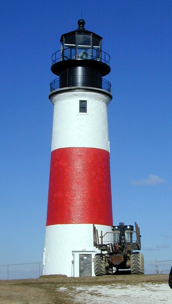
The Nantucket Harbor Range Lights Location Brant Point, Nantucket, Massachusetts Coordinates 41°17′21.4″N 70°5′30.9″W / 41.289278°N 70.091917°WCoordinates: 41°17′21.4″N 70°5′30.9″W / 41.289278°N 70.091917°W[1] Year first lit 1908 (current tower) Construction Wood Tower shape Pyramidal Skeleton Tower Markings / pattern KRW 
Height 46ft (14m) Focal height 51ft (16m) Original lens Higher intensity beam to seaward. Characteristic Fixed White Fog signal none USCG number 1-15165 Nantucket Reef Range Front Light 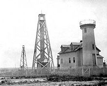
Old Brant Point Light is to the right
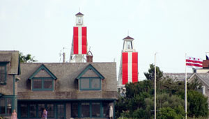
U.S. Coast Guard photoLocation Brant Point, Nantucket, Massachusetts Coordinates 41°17′23.6″N 70°5′32″W / 41.289889°N 70.09222°W[1] Year first lit 1908 (current tower) Construction Wood Tower shape Pyramidal Skeleton Tower Markings / pattern KRW Height 30ft (9m) Focal height 35ft (11m) Original lens Higher intensity beam to seaward. Characteristic Q W Fog signal none USCG number 1-15160 The Nantucket Harbor Range Lights are range lights which were built in 1908 to guide vessels through the narrow channel to Nantucket Harbor. They replaced an older arrangement, known as Nantucket Range Lights, which became unusable when the current Brant Point Light replaced the 1856 Brant Point Light tower.
They display red and white vertical striped daymarks, type KRW, one of the twelve combinations used by the Coast Guard.
It is not known why the official USCG name of the front light, Nantucket Reef Range Front Light[2] includes the word "reef".
References
- ^ a b The coordinates shown are the official coordinates from the cited Light List and are shown to the precision given there.
- ^ a b c (PDF) Light List, Volume I, Atlantic Coast, St. Croix River, Maine to Shrewsbury River, New Jersey. Light List. United States Coast Guard. 2009. p. 135. http://www.navcen.uscg.gov/pdf/lightLists/LightList%20V1.pdf.
- ^ a b "Historic Light Station Information and Photography: Massachusetts". United States Coast Guard Historian's Office. 2009-09-14. http://www.uscg.mil/history/weblighthouses/LHMA.asp.
- ^ a b Rowlett, Russ (2009-09-14). "Lighthouses of the United States: Southeast Massachusetts". The Lighthouse Directory. University of North Carolina at Chapel Hill. http://www.unc.edu/~rowlett/lighthouse/ma2.htm.
Categories:- Lighthouses in Massachusetts
- Buildings and structures completed in 1908
- Buildings and structures in Nantucket, Massachusetts
- Lighthouses in Nantucket County, Massachusetts
- United States lighthouse stubs

Wikimedia Foundation. 2010.